
2D and 3D Map creation
Topographer is a major application both for general use and the Geography curriculum when it allows children (and teachers) to have lots of fun whilst learning all about maps, contour lines, valleys, rivers etc. In fact Topographer covers virtually all items found on Ordnance Survey maps.
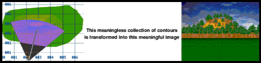
The real breakthrough with Topographer is its 3D section which allows you to convert a 2D map into a 3D model on screen. Imagine turning a set of flat contour lines on a 2D map into a 3D model which clearly shows the hill - no more cardboard cutout models or papier mache ! You define where you look from, what you look at.
Topographer also covers aspects of the IT and maths curriculum with its modelling capabilities. Just stop for a minute and think of the projects that children could do with Topographer. They could make a map of the local area with churches, pubs, woods, hills etc and then view it from various places. If there is a new bypass proposed they could add it in to the existing landscape and see where it is visible from and what impact it is likely to have on the community. I'm sure you can think of a hundred and one topics.
- Easy and quick entry of all symbols (over 100) onto 2D map
- Easy entry and editing of contour lines using specialised routines
- Definable widths for roads and rivers
- Wooded areas which translate into impressive 3D landscapes
- Map can be saved as Draw file and printed if required
- Definable map size and scale which can be linked to the national grid references
- Zoom option which is independent of the scale
- Powerful 3D mode giving a true representation of the landscape
- Definable viewing coordinates, height and angle (numerically or graphically)
- Stunning 3D models which can be saved as a sprite file for use in other applications
Topographer costs just £19
Price includes UK carriage. Please add £2 outside UK.
...an excellent resource for teaching mapping to school children. ...very reasonably priced. Very highly recommended.
Silicon Village
This is a sophisticated and exciting piece of software which has a wide application across all the National Curriculum Key Stages. In the primary classroom this package could be used by the teacher to enable pupils to investigate maps (NC Geography AT1 levels 1 - 4). ..it is an excellent way of showing how two dimensional contours represent a three dimensional landscape. The manual for the program is very user friendly....
Primary Geographer

This web site © APDL 2008. Artwork produced using DrawWorks XL
|