 Guillestre
Provence-Beyond (Beyond the French Riviera) ®
Hautes-Alpes (05600)
Population: 2000
Altitude: 1050 m
Michelin map: #245 "France Provence-Cote d'Azur"
Nearby:
[ Briançon 36 km | Embrun 21 | Mont-Dauphin 5 | Les Orres 33 | Queyras | Saint Paul-sur-Ubaye 27 | Saint Véran 32 ]
Photos:
1 Guillestre old town, looking north to the mountains (41 k)
2 Gorges de Guil looking west; Guillestre is hidden to the left; Mont-Dauphin in the background (37 k)
3 Old houses on the Rue des Pelerins, beside Le Rif Bel (37 k)
4 Maison de la Grenette in its shades of grey (47 k)
5 The fountain on the Place du Gal Albert (48 k)
6 A wooden barrel fountain with a bouquetin faucet (43 k)
7 A typical attic crane with its everyday load of flowers (33 k)
8 The Tour d'Eygliers -- a renovated tower on the medieval town wall (39 k)
9 Crouching lion with its prey between its paws -- like the pillar lions of Embrun and St Véran (29 k)
10 An 18th century sundial at the rue de la Frairie (46 k)
Below: [ Market | Church | Playground | History | O.T. | Dining | Transportation | Hiking | Lodging ]
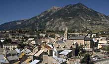 Guillestre is a very picturesque little town, set in a deep valley. The area is beautiful, surrounded by thickly forested mountains. Photo-1 is a view across the old town towards the north. The river Guil river flows out of the wild Gorges de Guil [Photo-2], past Guillestre and Mont-Dauphin, and into the Durance.
Part of the town's charm is that it's "authentic" looking, although that could be translated to not restored or even partially run-down. There is restoration going on though, with neat pastel-colored houses set in amongst the rough wood and morter buildings in the narrow old streets.
In the center of town are large squares and shops. Among the many fountains in Guillestre are the typical large ones in the center squares [Photo-5] and this wooden one we found on a side street [Photo-6].
With tall houses and narrow streets, wooden cranes are common in upper-floor windows. Since they're not often in use, many spend their idle hours suspending pots of colorful flowers [Photo-7].
Street Names. "Rue Casse Cul" is a very narrow step-street up between ancient buildings. Near the top, it joins with "Rue Joli Coeur" and "Premiere Grand Rue", a little street that's under 2 m wide at its widest. Above the village, the "Chemin du Silence" leads to the cemetary.
Of the few sundials we found in Guillestre, this one on the rue de la Frairie [Photo-10] is the nicest.
Market
There's a very large market here every Monday morning. This is the market town for the Queyras, and people come in from all around.
Church
The church of Guillestre is "inspired" closely by the cathedreal in Embrun, even to the pair of lions supporting the columns [Photo-1]. This church is smaller, of course, but has an interesting porch in front.
Playground
A grassy slope under shady plain trees, on the square at the bottom of Rue de Torre Pellice. It has merry-go-round, teeter-totter and slide for small children, and pleanty of benches for the parents.
History
Prehistoric:
Bronze age habitation.
Celto-Ligurian:
This was the site of important Gaulish habitation. The Gaulish cemetery at Peyre-Haute (2 km southeast) had bones and jewelry.
Medieval:
The upper village was established in the 12th century by the occupants of La Rame, when their village was destroyed by flood. Guillestre was a fortified town during the 14th, 15th and 16th centuries, and some of the walls can be seen today, including the restored Tour d'Eygliers [Photo-8].
- Office de Tourisme
- Tel: 04 92 45 04 37; Fax: 04 92 45 19 19
- Dining
-
Lunch - Creperie La Bolée
The 70 F menu was salad, jambon cru, tourtons [photo], and dessert of "faisselle aux myrtilles". There's also a 48 F plat de jour.
- Tourtons are a regional specialty for the Haute Alpes: small potato pastries stuffed with a mashed potato and blanc de poireau. The ones we had were a mass-produced variety, stuffed with creme fresh, cheese and potato; we found them fine, but the waiter assured us the "real artisanal" ones were much better. Although deep fried, they're not made with a beignet dough and aren't at all greasy. - Dinner - "Le Grange" restaurant.
-
Run by a Dutch family (who speak French, English, German and Dutch), Le Grange has a terrace balcony with a really great view down the valley. During your first course you can watch the sun setting over the nearby mountains, and during dessert you can watch the stars coming out in the clear mountain air.
- Menus: 95, 115 and 130 F.
We tried for an entré the "salade rouge", made with red batavia lettuce, tomato, beet cubes, strawberries and Dutch cheese, with a sauce of huile de noix, creme de cassis and vinaigre de framboises. Our main course was grilled salmon, served with small separate side dishes of broccolli, lettuce-olive-tomato-goat cheese salad, and large french-fried potato slices. - Dinner - Hotel Le Chalet Alpine
-
Chausson de saumon farci aux huitres - 95F
- a roll of salmon stuffed with steamed oysters, shrimp and spinach.
Noix de St-Jacques aux fruits frais, sauce aigre douce - 105F - scallops (whites and corail), served in a bed of manderin orange slices, kiwi, raspberries, blueberries and raspberry sauce.
White Wine: Chateau de Roquefeuille, Cote de Provence, from Le Val Claret, 06600
Transportation
Train
The Mont-Dauphin Guillestre station is 5 km away, beside the N49 highway in the valley. A navette (shuttle bus) provides service between Guillestre and the station.
- Paris-Gap-Briançon
- Briançon-Gap-Serres
- Briançon-Gap-Grenoble
- Marseille-Gap-BriançonBus
The Transports Urbains de Briançon (TUB) provides complete service for the area around Briançon and Mont-Dauphin.Place de Suse; 05100 Briançon Tel: 04 92 20 47 10; Fax: 04 92 20 52 77Bus service for Marseille, Aix-en-Provence, Sisteron, Gap, Embrun, Guillestre, Briançon.
- Paris-Gap-BriançonBus service for the Queyras mountain region.
- Mont-Dauphin--Queyras
- Hiking
- Maps:
- Didier Richard (1/50,000) #10 "Queyras Pays du Viso";
The mountains to the north has several Petite Randonnée (PR) trails as well as the GR541 Grande Randonnée, with peaks up to 2645 m [photo-1].
There are shorter PR trails in the heavily forested mountains to the east, with peaks to 2734 m.
South of Guillestre is a bit less wild, with several small villages. Most of the mountains here are under 2000 m, until the Pic du Clocher (2473 m) 8 km to the southeast.
Hiking to the west is on the right bank of the Durance, where the GR50 runs north-south on the slopes above the river.