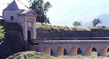
 Mont-Dauphin
Provence-Beyond (Beyond the French Riviera) ®
Hautes-Alpes (05600)
Population: 73
Altitude: 1050 m
Michelin map: #245 "France Provence-Cote d'Azur"
Nearby:
[ Briançon 31 km | Embrun 18 | Guillestre 5 | Queyras | Saint Paul-sur-Ubaye 32 | Saint Véran 37 ]
Photos:
1 The fortress exterior on the cliffs, viewed from the direction of Guillestre ( k)
2 The fortress exterior, viewed from the west ( k)
3 Asses grazing in the outer moat of Mont-Dauphin fortress ( k)
4 The entrance way building from inside ( k)
5 The main village street inside the fortress ( k)
6 The fountain in the center of the village ( k)
7 An 18th century stone grain-measuring basin ( k)
8 Sundial on the Atelier Acacia, at the old casern buildings ( k)
Below: [ Fortress | History | O.T. | Transportation | Hiking ]
 This very impressive and very fortified hilltop site overlooks the Durance river, 4 km west of Guillestre. Mont-Dauphin (variously spelled Mont Dauphin and Montdauphin) is the smallest geographical commune in the department, with a total of 58 ha. The site commands an impressive view in all directions, and there are open grassy areas to wander while enjoying scenery of the surrounding mountains and valleys.
The entire top of the hill is fortified, by Vauban at the end of the 17th century. Photo-1 and photo-2 give an idea of what it looked like to invaders, with the walls just an extension of the natural defenses. Buildings and fortifacations are built from a hard and lovely rose marble. Today asses graze inside the double sets of wide moats [photo-3].
Inside the fortress is a small village, layed out in military fashion with wide streets in precise rectangles. There are a few shops and cafés in the village.Photo-5 is a view down the main street, and Photo-6 is the fountain at the junction of the lower cross street.
At a corner of the cross-street junction in the center of the village is a stone grain-measuring basin [photo-7], with measures and prices marked for 1748.
On the left side, as you enter, is a very long building that was once the cassern. There, across from the little Office de Tourisme, we found a sundial (cadran solaire) maker. Apart from the small models available to passing tourists, he has a catalogue of some very impressive one's he's made; and he makes them on command. They're not easy to ship, however. A sample of his work is on the outside wall [photo-8].
Fortress
The Piemontais invaded the Dauphiné twice in the 17th century: in 1691 via the Col de Vars, from the southeast (coming via the Col de Larche and Meyronnes); in 1692 via the Queyras, from the northeast.
In 1692, Vauban was asked to come and review the Plateau de Millaures (meaning mille-vents, or a thousand winds), a site that overlooked both entries into the region. Since the hilltop was partially surrounded by cliffs, it would only need to defend a relatively short front.
Vauban layed out the defensive positions and designed an interior town, with caserns, arsenal and church. Vauban returned in 1700 to complete the defenses and extend the walls completely around the plateau, work that took place slowly during the 18th century.
Continued modifications and improvements took place well into the 19th century. The inhabitants of the region didn't flock into the town, and Mont-Dauphin remained essentially a military fortress only.
History
The village and fortress were built at the end of the 17th century by Vaubian and Catinat, following the invasion of Dauphiné by the Duke of Savoy and the destruction of Eygliers.
- Office de Tourisme
- Tel: 04 92 45 17 80
Transportation
See Guillestre.
- Hiking
- Maps:
- Didier Richard (1/50,000) #10 "Queyras Pays du Viso";