 Embrun
Provence-Beyond (Beyond the French Riviera) ®
Hautes-Alpes (05200)
Population: 6500
Altitude: 871 m
Michelin map: #245 "France Provence-Cote d'Azur"
Nearby:
[ Boscodon Abbey 11 km | Briançon 50 | Ecrins National Park 12 | Guillestre 21 | Le Lauzet-Ubaye 35 | Mont-Dauphin 18 | Les Orres 12 | lac de Serre-Ponçon 2 | Trip Report ]
Photos:
1 Embrun sitting on the cliffs above the Durance river, with Mont Guillaume behind (37 k)
2 A view northeast of Embrun, on the cliffs (36 k)
3 Embrun's Hotel de Ville building on Place E. Barthelon (42 k)
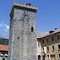
4 The 12th-century donjon tower Tour Brune (35 k)
5 16th century fountain at the end of Rue Chaffuel at Rue de la Liberté (37 k)
6 The 18th-c pink-stone column fountain at Rue de l'Hopital; dedicated to the "12e Bataillon des Chasseurs Alpins"; (36 k)
7 A fantasy sundial at the Place E. Barthelon in the center of the old town (37 k)
Below: [ History | Dates | O.T. | Transportation | Sports | Hiking | Lodging ]
 The town of Embrun sits on a cliff-top plateau (the "Roc") overlooking the upper Durance river just before it flows into the Lac de Serre-Ponçon [photo-1]. The hills closely surrounding the town are covered with modern buildings and holiday chalets, not at all pretty. A view of Embrun from across the river, though, with the higher mountains beyond, is lovely [photo-2], and the center of the town is ancient and interesting.
Although the town is ancient and still has many old buildings, it's well restored and seems very neat and modern. It's a pleasant enough town, with several squares, and a pedestrian zone with shops and market stands. At the Office de Tourisme, in grand looking old building, probably an old church, you can get a free map of the town.
There are enough narrow old streets to make exploring interesting, and the main pedestrian street through the center is an active market place. The Place E. Barthelon, in the center of the old town, has a large fountain, several terrace cafés and other shops, and a Provençal-pastel city hall [photo-3]
The Cathedral Notre-Dame-du-Réal is an impressive building, and the main portail, "le Réal" is listed as a remarkable example of Lombard art. We especially like the lions supporting the rose-marble columns. (A copy inspired by these supports the "réal" of the church in Guillestre, and we found a pair of identical lions, also holding their prey between their paws, supporting the columns of the church in St Véran.)
Behind the 12th-c Cathedral is the 12th-c donjon Tour Brune [photo-4]
We toured the town by searching out the old fountains, of which Embrun has several. Many of the fountains are of a similar style to this 16th-c one on Rue Chaffuel [photo-5]. We found other ancient stone fountains at Place St Marcelin, Place E. Barthelon, and a small one between the Cathedral and the Tour Brune. On the Square Lapeyrouse at the west side of town is a 17th-c rose-marble fountain with a column dedicated to the Chasseurs Alpins [photo-6].
Sundials. We found only one sundial (cadran solaire) in Embrun, a rather fantasy version, on the Place E. Barthelon [photo-7].
Park. There's a shady little park area at the edge of town past the Cathedral, at the edge of the "Roc" overlooking the Durance valley.
History
Name
First record, Eburodunum
Gallo-Roman:
Eburodunum was an important Roman town on the Briançon--Arles Roman road. In the 4th century, a bishopry was founded here by Saint Marcellin. In 804, the bishop became an archbishop, and soon after Embrun was attached to the Germanic Roman empire Saint-Empire.
Dates
Market: every Wed and Sat
- Office de Tourisme
- Tel: 04 92 43 72 72; Fax: 04 92 43 54 06
- Located in the gothic side-chapels of the ancient convent of "Les Cordeliers", consecrated in 1447.
Transportation
Embrun has the following train service:
Paris--Gap--Briançon
Briançon--Gap--Serres
Briançon--Gap--Grenoble
Marseille--Gap--BriançonEmbrun has the following bus service:
Marseille--Embrun--Briançon
Sports
- Rafting and kayaking on the Durance.
- Mountain biking (VTT cycling), with 380 km of marked routes.
- Canyoning
- Horse riding
A multitude of water sports on the adjacent Lac Serre-Ponçon
- Hiking
- Maps:
- Didier Richard (1/50,000) #7 "Hautes Alpes"; #10 "Queyras Pays du Viso"
To the west, the GR50 circles the flanc of Mont Guillaume, follows the river valley to Les Gourniers (about 15 km), then comes back southeast before again going west to Ancelle and beyond. To the northeast, The GR50 goes past Châteaureaux and St Marcellin and points north.
There are other shorter trails on the east side of Mont Guillaume, and there are some loops possible using part of the GR50. Because of the steep rocky nature of the northern part of the mountain, no trails circle Mont Guillaume other than following the river valley northwest of St Marcellin, well to the north.
Southeast of Embrun, a trail crosses the river and goes out past St Sauveur, then through the Forêt du Meale or southeast to Les Orres.