 Saint Véran
Provence-Beyond (Beyond the French Riviera) ®
Hautes-Alpes (05350)
Population: 257
Altitude: 2040 m
Michelin map: #244 "France Rhône-Alpes"; #245 "France Provence-Cote d'Azur"
Nearby:
[ Briançon 51 km | Château-Queyras 13 | Guillestre 32 | Mont-Dauphin 37 | Queyras ]
Photos:
1 Wooden attic houses in the center of the village (33 k)
2 The lower part of St Véran village (29 k)
3 An old "general store" (alimentation) in St Veran (41 k)
4 One of the many wooden fountains in St Véran (37 k)
5 A 1926 village hand-pump fire wagons (37 k)
6 A modern-old village house on hill with grazing goats (same house as #11) (32 k)
7 Typical old house in the center of Saint Véran (41 k)
8 Wooden buildings from above and a misty mountain valley (36 k)
9 A 19th century yellow and blue sundial on the side of a St Véran house (39 k)
Below: [ History | O.T. | Dining | Transportation | Hiking | Lodging ]
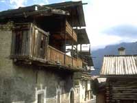 Billed as the highest village* in Europe, St Véran sits out on an exposed grassy mountain flank above a beautiful river valley in the Queyras mountains. The village has very picturesque house-barns with large complex wooden attics and multiple wooden storage balconies. Even the more modern, or refurbished, houses have kept the special style of the village [photo-6].
* (The highest town in Europe is Briançon.)
The village was once divided into 5 sub-villages, separated for fire protection because of the extensive wood construction. Each "division" had it's own name (Forannes, La Ville, Villard, Pierre-Belle and Les Raux), it's own wooden fountain, and it's own fire pump. Today the village is more unified, but if you explore the village well, you will clearly see the separate divisions.
There's still one principle wooden fountain [photo-4] for each division of St Véran, each unique. The village was split into separated divisions in the beginning of the 19th century because of previous fires, and the fire pumps [photo-5] were first bought in 1874. Modern pressure hoses superceded the hand pumps, but when the modern equipment was frozen solid in December of 1967, the hand pumps worked well and put out the fire -- for the last time.
Sundials can be found grouped in different parts of the Haute-Alpes department, with many in the village of St Véran. We found and photographed 10 in the village, like this one [photo-9], and others nearby, such as Moulines-en-Queyras and Château-Queyras.
St Véran is a popular destination for tourists and hikers, but even with a fair number of souvenir shops and several cafés, restaurants, hotels and Gites, it's still very natural and authentic; [photo-3] for example, shows a typical "general store", although there are some more modern shops as well.
The lovely old buildings have a mixture of roofs, using corregated metal, wooden planks or large flat-stone "tiles". You can see some of the big slate tiles in [photo-2] and [photo-8]
The small Office de Tourisme in the upper village has posted the weather forecast, very important if you're planning a day's hike. The weather of the moment could be completely different by the time you get out into the hills.
History
St Véran was the capital of Queyras, where there was war with the Vaudois in the 12th century. Even in this isolated mountainous area there was religious war; the Hugenots destroyed the church in the 16th century.
Prehistoric:
There was a prehistoric presence here, even before the copper mines that have been in production, off-and-on, from the Bronze age through to modern times.
Celto-Ligurian:
Gauloise burial tombs have been discovered in this region.
Dates
Dates 16 July Fête patronale at Clausis 14 Nov Fête
- Office de Tourisme
- Tel: 04 92 45 82 21
- Dining
- There are several restaurant possibilities in the village.
- We had lunch in a small café-bar-restaurant (and hotel), the "Coste-Belle". The salade de chevre chaud and the salade gesiers volailles we had for starters were very good, and a good-sized meal in themselves, as it turned out. Still, we managed to finish the Tourtons Champsaur: a variety of potato pastry with a sort of mashed potato stuffing.
Transportation
Bus service for the Queyras mountain region.
- Mont-Dauphin--Queyras
- Hiking
- Maps:
- Didier Richard (1/50,000) #10 "Queyras Pays du Viso";
The GR58 goes through the village. To the southeast, the GR58 follows the river valley as far as Chapelle de Clausis (about 6 km, 2340 m), then splits to climb the Col Agnel (2744 m) or the Col de St Véran (2844 m). To the southwest, the GR58 drops down to cross the river at the Pont du Molin (1849 m) and then climbs over the Col des Estronques (2651 m) and down to the village of Ceillac (1640 m). The GR58VT trail goes northwest down the river from St Véran and over the Col des Prés de Fromage (2146 m) a couple of km west of Moulines-en-Queyras.
In this very mountainous area, there are few loop hikes possible. The best ones marked on the map are northwest of St Véran and between Château-Queyras, Moulines-en-Queyras and Aiguilles.