 Le Lauzet-Ubaye
Provence-Beyond (Beyond the French Riviera) ®
Alpes-de-Haute-Provence (04340)
Population: 212
Altitude: 900 m
Michelin map: #245 "France Provence-Cote d'Azur"
Nearby:
[ Barcelonnette 21 km | Boscodon Abbey 32 | Embrun 33 | lac de Serre-Ponçon 5 | Seyne-les-Alpes 24 | Ubaye Valley | Trip Report ]
Photos:
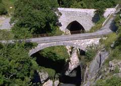
1 The Roman bridge behind the "new" bridge at Le Lauzet-Ubaye (50 k)
2 A closer view of the Roman bridge over the Ubaye river (50 k)
3 A village street, with flowers and mountains; a ramp to an upper-floor barn is in the background (55 k)
4 A village street with a covered overhead passage (37 k)
5 Fountain and church at the main village square (42 k)
Below: [ History | Hiking | Lodging ]
 Le Lauzet-Ubaye is a small mountain village built on the gorge of the Ubaye river, a few kilometers before it empties into the Lac de Serre-Ponçon.
The village is built on a sort of narrow rock island, with a deep valley in front and the deeper gorge of the Ubaye river behind.
Le Lauzet-Ubaye is a small mountain village built on the gorge of the Ubaye river, a few kilometers before it empties into the Lac de Serre-Ponçon.
The village is built on a sort of narrow rock island, with a deep valley in front and the deeper gorge of the Ubaye river behind.
The narrow streets between the houses have a medieval feel, but the roofs, balconies and wide ramps leading to the upper-floor barns is Alpine style [photo-3, photo-4]. There's a big stone church in the center of the village, with a nice fountain in the center square [photo-5]. Village commerce consists of a few shops and café-restaurants.
A tiny road goes down to the "new" bridge over the gorge, just beside the arched stone Roman bridge [photo-1, photo-2]. Another path, probably the old Roman road, loops around the rocks to bring you back to the village.
History
The commune of Le Lauzet-Ubaye combined the villages of Ubaye and Lauzet, but Ubaye was flooded in 1960 when the Serre-Ponçon dam was completed and the lake was created.
Gallo-Roman:
A Roman presence here is attested to by the beautiful single-arch Roman bridge across a deep gorge of the Ubaye river [photo-2].
Medieval:
The Counts of Provence ruled this area until the 14th century, then the Dukes of Savoy until 1713.
Dates
Dates Every Thur Marché 1st Thur Foire 2nd Mon Foire 25 May Foire 10 Aug Fête 6 Oct Foire 20 Oct Foire 22 Dec Foire
- Hiking
- Maps:
- Didier Richard (1/50,000) #1 "Alpes de Provence";
The mountains to the south are the most forested, with peaks at about 1500-1800 m. The northern slopes are forested up to around 1700-1800 m, but the peaks go up to 2500-2800 m.