 Facts at a Glance
Full Name: Antarctica
Area: 14.25 million sq km
Population: The winter (nontourist season) population is around 1200 people
People: Workers from various countries operate research stations.
Government: No country has any definitive sovereignty over any part of Antarctica although Argentina, Australia, Chile, France, New Zealand, Norway and the United Kingdom all have territorial claims. The continent has been administered by the Antarctic Treaty since 1961.
Antarctica (where the South Pole is located ) is the fifth-largest continent in the world, around twice the size of Australia. It's the world's most arid continent (technically a desert) and, at an average elevation of 2250m, it's also the world's highest. The highest point is the 4897m Vinson Massif. Recent satellite imaging has established that 99.6% of the continent is covered in ice, and this represents 90% of the world's ice - 30 million cubic km, around 70% of the world's fresh water. The Antarctic Circle is an imaginary line in the Southern Ocean parallel to the equator at a latitude of 66° 32' south. Antarctica's nearest continental neighbour is South America, around 1130km away from the tip of the Antarctic Peninsula. Considerably further away are the southern tips of the Australian and African continents.
 Arched iceberg (16K)
Plant species in Antarctica are far more numerous than you might expect given the region's harsh climate and aridity, but they're all humble little life-forms. There are hundreds of species of algae, around 350 species of lichen, 100 species of moss, two grass species and a pearlwort. There are even some lichens and algae that grow inside rocks - endolithic plants. Of course the subantarctic islands support a much wider variety of flora species with South Georgia alone having at least 50 vascular plants.
Leopard seal layabout (12K)
The largest of the endemic land-based animal species is a wingless midge (Belgica antarctica) that grows to just over a centimetre. The rest, all invertebrates, are even smaller. About 45 bird species breed south of the Antarctica Convergence, and just a few of those, mostly penguins and petrels, on the Antarctic continent itself. The Southern Ocean, by contrast, teems with life and supports vast numbers of fish, seal, whale and seabird species.
Unlike all the other continental land masses, Antarctica's existence was postulated long before it was discovered. Indeed, both Pythagoras and Aristotle felt that the globe would be top-heavy and topple over if there weren't a sizeable land mass to balance it. For hundreds of years Europeans thought that this land mass must be enormous and that it would be connected to the southern extremes of the known continents. However, voyages by Días de Novaes and João Infante (1487-88), who rounded the southern tip of Africa, and the Portuguese Vasco da Gama (1497) and Ferdinand Magellan (1519-22), who discovered Tierra del Fuego, proved that the Great Southern Land was not connected to the South American and African continents.
James Cook, on the second of his three great voyages, became the first person to cross the Antarctic Circle on 17 January 1773, but he circumnavigated Antarctica without once sighting land. He was not greatly perturbed by this, claiming that `should anyone possess the resolution and fortitude to... (push) yet further south than I have done, I shall not envy him the fame of his discovery, but I make bold to declare that the world will derive no benefit from it'. Cook's sentiments discouraged further exploratory ventures in the region for decades, but his observations on the huge seal and whale populations encouraged sealers and whalers to arrive in droves: nearly one third of the Southern Ocean and subantarctic islands were subsequently discovered by sealers.
Whale bone tombstones (22K)
In January 1820 Fabian von Bellingshausen, a captain in the Russian Imperial Navy who had led the first Russian circumnavigation of the globe, became the first person to see the Antarctic continent. He described it as `an icefield covered with small hillocks'. His return to Russia, however, was barely acknowledged. It was 120 years later, at the onset of the Cold War, when his achievements were properly appreciated - the Soviet Union was then keen to establish its claims in the Southern Ocean and the Antarctic.
In 1819 and 1822, Scotsman James Weddell captained sealing voyages to the South Shetland Islands and discovered the South Orkney Islands. By the end of January 1823 Weddell had reached the southern end of the South Orkney archipelago and made a landing on Saddle Island where he took six skins of an unknown species of seal (today known as the Weddell seal). By February he had reached 74 degrees 15' south, a new southing record. He named the sea after sovereign King George IV, but this century it was renamed the Weddell Sea.
Frenchman Jules-Sébastien-César Dumont d'Urville (the man who had earlier convinced the French government to purchase a newly excavated statue from the Greek isle of Milos that he quite liked - the Venus de Milo) set forth from Toulon in 1838 with orders to sail south into the Weddell Sea as far as possible. He'd hoped to reach the South Magnetic Pole (magnetism was then one of science's biggest conundrums) but ice prevented him from getting anywhere near where Weddell had. He did, however, discover Louis Philippe Land and Joinville Island at the northern tip of the Antarctic Peninsula, although sealers had probably already landed on both. After sailing in the Pacific he headed south again and, in January 1840, finally sighted land. Sheer ice cliffs prevented a landing on the mainland, so d'Urville chose to land on an island a few hundred metres offshore. Samples of granite were taken, and the discovery of the Great Southern Land was claimed for France.
Belgian navy lieutenant Adrien Victor Joseph de Gerlache de Gomery's expeditions left Punta Arenas, in Chile, very late in the season in December 1897. Some speculate that de Gerlache knew full well that this would mean the Belgica would become beset with ice and that he would be the first to command an expedition that endured the Antarctic winter. Indeed, by March 1, at 71° 31' south, well inside the Antarctic Circle, the Belgica was stuck in heavy ice and for 377 days the ship did not budge. Midwinter darkness, extraordinary hardships and the threat of scurvy took their toll on the expedition, and there was a genuine fear that the craft would never move again. The crew ate fresh seal and penguin meat to prevent the onset of scurvy and elaborate games were organised to prevent madness.
By January 1899 the situation was desperate. A decision was made to hand-cut a channel from a stretch of open water 600m away to the Belgica's bow in an effort to free her. For a month all hands worked furiously and hewed a canal to within 30m of the vessel, but then the wind shifted, the pack ice tightened and the channel closed up within an hour. And then just two weeks later another shift in the wind reopened the channel and the Belgica was freed. They had to wait yet another month before they reached open sea, but they finally limped into Punta Arenas in March 1899. The real achievement of the expedition was that it provided proof that permanent bases could be established on Antarctica, and that humans, with good provisions and equipment, could survive the Antarctic winter. This was also the first expedition to bring back photographs of this eerie frozen world.
Carsten Egeberg Borchgrevink headed the first venture to establish firm bases on the continent. An ostensibly English expedition (two Englishmen, one Australian and 28 Norwegians) left London in August 1898 and arrived in Antarctica in February the following year. Two simple huts were erected and 10 men were left behind as the expedition ship departed to spend the winter in New Zealand. Borchgrevink had also brought 90 sledge dogs, kayaks for sea travel and a new Swedish invention: the Primus stove. Despite one death, some near disasters and an ambivalent reaction on returning to London, this exercise was the start of modern Antarctic research.
Captain Robert Falcon Scott's well-financed expedition in the Discovery left England in August 1901, crossed the Antarctic Circle in January 1902, and stopped at Cape Adare. Scott penetrated the Ross Sea and cruised along the Ross Ice Shelf discovering King Edward VII Land on the shelf's eastern flank. He also made the first flight in Antarctica in a tethered balloon called Eva, reaching a height of 240m. Scott's men built a hut at Ross Island but their ship, stuck in the ice, served as accommodation. The men endured the winter with the comfort of windmill-powered electric lights, their own Royal Terror Theatre, and the production of Antarctica's first magazine, the monthly South Polar Times (a more ribald version, The Blizzard, was concurrently produced).
With spring came the real work: Scott and two others, with 19 dogs and five supply sledges, took off for the South Pole. None had skied or driven sledge dogs before and their inexperience was telling. Despite this, they reached 82° 16.5' south before they turned back, but the return trip was awful. The dogs were now useless - they were actually hitched behind the sledges which were pulled by the three exhausted men. As the dogs weakened they were shot and fed to the others. They made it back to the Discovery to find that the relief ship Morning had arrived. The Discovery was still frozen solid in the ice and Scott decided to send eight men home aboard the Morning and spend yet another winter on the continent. The following summer Morning returned with another ship and orders from the British government that if Discovery couldn't be freed in six days then she should be abandoned. Scott and the crew worked furiously to free the vessel with cutting implements and explosives and, eventually, she sailed away.
Norwegian Roald Gravning Amundsen, who had been part of the de Gerlache expedition that wintered in Antarctica, set sail from Christiana (modern-day Oslo) in 1910 in a bid to be the first man to reach the North Pole. However, on hearing news of American Robert E Peary's claims to have already reached the North Pole, Amundsen did a literal about-face. Aware of Robert Scott's rival expedition, Amundsen secretively headed south. The expedition's base was established on the Ross Ice Shelf (where Scott had made his balloon flight), and consisted of a small wooden hut and 15 large tents used to house stores and the expedition's 97 huskies. Setting out from this base on 19 October, 1911, Amundsen and four others headed for the Pole. The planning was meticulous: Amundsen took three or four backups for every critical item and set up 10 well-marked depots down to 82 degrees south. On 14 December, 1911, Amundsen and his party reached the South Pole, claiming it for Norway, and made it look easy. Amundsen left a tent at the Pole with a note inside for Scott to read.
Meanwhile, Scott was preparing another sortie and was desperate to beat Amundsen to the South Pole. He sailed from New Zealand in November 1910, arrived at Ross Island in January 1911 and established quarters at Cape Evans on Ross Island. Horses, mules, dogs and motor-sledges were employed with mixed success, and, with the oncoming spring, the final push to the Pole was launched on 2 October. Four men accompanied Scott towards the South Pole. The journey was impossibly difficult, but they did reach the Pole only to find that Amunsden had been there 23 days earlier. Scott's disappointment was enormous, and the party turned around to begin the return journey. Two men died within two months, and the surviving three pushed on for another month until, just 18km from base, the weather pinned them down. Scott's last journal entry was 29 March and their frozen bodies were found eight months later by a search party.
 Off the record: Mawson's long trip home
There were others who played important parts in the opening up of the Antarctic, all of them obsessive and driven individuals. They include: Erich Dagobert von Drygalski, a University of Berlin geography professor; Swede Nils Otto Gustav Nordenskjöd Scotsman William Spiers Bruce; Frenchman Jean Charcot; the great Irishman Ernest Henry Shackleton; Japanese Nobu Shirase; and Bavarian Army lieutenant Wilhelm Filchner. Then came WWII and the era of the private Antarctic expedition was over. After the war only governments could afford to mount Antarctic expeditions, and in 1943 the British began the permanent occupation of the continent.
In 1946, the US Navy Antarctic Developments Project, or `Operation Highjump', was launched and it was perhaps the biggest single event that the continent had ever seen. It was the beginning of the Cold War and the exercise was designed to give US troops experience in polar conditions - 4700 men, 33 aircraft, 13 ships and 10 caterpillar tractors were deployed, and helicopters and icebreakers were used for the first time in Antarctica. In February 1954, the Australian National Antarctic Research Expeditions (ANARE) established Mawson station. This was the first permanent scientific station and the only one outside the Peninsula.
The International Geophysical Year (IGY), which lasted from July 1957 to December 1958, brought together the research activities of 66 countries. As part of this, 12 countries - Argentina, Australia, Belgium, Chile, France, Japan, New Zealand, Norway, South Africa, the UK, the USA and the USSR - established more than 40 bases on the Antarctic continent and a further 20 on the subantarctic islands. It was the spirit of international cooperation promoted by the IGY that lead directly to the signing of the Antarctic Treaty, which has administered Antarctic affairs since 1961.
The Norwegian invention of the exploding harpoon in 1870 revolutionised whaling and its impact was felt in the Antarctic waters as much as anywhere. Between 1904 and 1966, when the majority of whaling ceased, a total of 41,515 blue whales were caught along with 87,555 fins, 26,754 humpbacks, 15,128 seis and 3716 sperm whales - a total of 175,250 animals! And today around 300 whales are still taken from the Antarctic waters by the Japanese for `research'; that is, they sell the flesh to fund their marine research programmes (whale meat is highly prized in Japanese eateries). Krill is harvested by the Japanese (and a small amount by Russia) at around 100,000 tonnes per anum. The long-line trawling techniques used for catching tuna in the Southern Ocean also manage to snare and drown about 40,000 albatrosses that steal bait from the lines. Iron ore, coal and other mineral deposits have been found on the continent but their quantities and qualities are unknown. Oil and natural gas are said to exist under the continental shelf but commercial exploitation is uneconomic.
Approaching the locals (16K)
Since 1988, two international conventions have been signed to protect the Antarctic from commercial mineral exploitation. The first was the Convention on the Regulation of Antarctic Mineral Resources Activities (CRAMRA) signed by all 26 members of the Antarctic Treaty. Australia and then France repudiated their signatures preferring instead the Protocol on Environmental Protection signed in Madrid in 1991 again by all 26 members of the Antarctic Treaty. This protects the continent from all mining activities for 50 years. The convention requires that all 26 countries enact national legislation to make it international law, and this is yet to happen.
The isolation of permanent station staff is long and profound. According to recent studies, returning expeditioners who've spent a year or more on the continent display characteristics similar to returning prisoners of war. As the last resupply vessel pulls away the wintering expeditioners, faced with 8 or 9 months' isolation with their comrades, can feel a mixture of dread and elation, but being cut off from the rest of the world is part of what's attractive for these hardy types.
Typically, station staff will be made up of a team leader, a doctor, chef, a handful of meteorological observers, a seismologist, upper-atmosphere physicist, a few diesel mechanics, a carpenter, plumber and an electrician. Over the years there have been a number of incidents that illustrate just how difficult it can be to be trapped on the ice with 15 or so imperfect human beings winter long: recently on Casey, the `tradies' (tradespeople) mutinied, got wildly drunk on home-brew and terrorised the other station staff. The ringleaders were sent home prematurely. During Mawson's 1911-13 expedition, a radio operator had a breakdown and dispatched bogus wireless messages. On Wilkes, years later, a diesel mechanic suffered a breakdown and began wielding a knife - he was confined to a makeshift padded cell for 5 months until he could be taken away aboard spring's first ship. A doctor on an Argentine expedition burnt down the base to force his evacuation, a Soviet scientist once killed a colleague with an axe over a game of chess and FBI agents were sent to the US McMurdo Sound base after two cooks were attacked with a hammer.
Bases often exhibit a distinct national character and typically have video rooms, billiard tables, libraries and bars. Concert evenings are common. Expeditioners have a penchant for clubs: the 300 Club, at the US Amundsen-Scott South Pole base, requires initiates to step naked into a sauna, heated to 200° Fahrenheit (93° Celsius), and then immediately step outside to run around the pole that marks the South Pole (there is one) at -100deg; Fahrenheit (-73° Celsius). The Vanda Swimming Club, at the New Zealand summer base, is made up of those who've broken through the ice of Lake Vanda, bared all and taken the plunge. They probably have a chess club too.
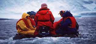
There are no indigenous peoples of Antarctica, but that doesn't mean that visitors shouldn't be respectful of fragile societies that do exist there. Antarctic bases are places of work and researchers need to take time out of their work to accommodate tourists. There's a desire amongst the Antarctic communities to be hospitable to visitors, but they are often pressed for time to complete their work before the season ends. Never enter any building unless you're specifically invited - you may interfere with scientific work or invade someone's privacy, a precious thing in a crowded base. Always take your shoes or boots off when you enter a station building - 90 tourists trudging mud into a base can take a long time to clean up. Never ask to use the toilet in a base: it's environmentally unsound to leave your waste on Antarctica when the facilities on your ship are available, and the onerous task of emptying or cleaning the toilet on the base is made all the worse when a bunch of unthinking tourists fill it to the brim. Perform your ablutions before you leave the ship.
Antarctica's most important holiday is Midwinter Day, on June 22, when the long polar night is half over. There are celebrations in all the bases which include feasting, games, songs and even local theatre productions. The last day of the sun and the first day of the sun are also important dates in the Antarctic calendar, although they fall on different dates depending on latitude. Visitors are unlikely to experience any of these festivities, however, because they occur during the long winter, but Christmas and New Year's Eve are celebrated with much enthusiasm and all the kooky style that a group of scientists and researchers can muster.
Visas: Since no-one owns Antarctica no-one needs a visa to visit it. However, shipping schedules are at the mercy of the ice and elements so, even if you are travelling directly from your home country, you will need to bring a valid passport since your vessel could quite possibly pull into the port of another country for shelter. You will need visas for any countries that your ship visits en route to Antarctica.
Health risks: Hypothermia, sunburn, dehydration, frostbite and snow blindness
Time: Clock time is largely irrelevant (the tourist season has about 20 hours' daylight each day), but most bases set their clocks in accordance with their home countries.
Electricity: Each ship and each base has its own independent electricity supply, but many of the ships are Russian with a 220V/50 Hz output into a standard European two-pin socket.
 Money & Costs
The cost of sea cruises varies, but if you're getting much change from US$5000 for a 14-day circuit, it's not a bad deal. Most ships have a range of accommodation options - if you don't mind bunking in with a few other penguin-spotters (and sharing the bathroom) you can reduce your bill significantly. At the other end of the scale, if you require a corner suite with a marble bathroom, private butler service and your own satellite telephone, you can start adding the zeroes.
Most Antarctic tour brochures carefully spell out what is not included in the price of the cruise. Typically, the additional costs of a cruise are for optional items including alcohol, laundry, faxes or phone calls, tips, souvenirs, extra helicopter time and massages. Watch out for operators who separate port taxes from their listed price as these are a hefty addition to the cost.
A chit system is generally used aboard ship, whereby you sign for purchases and reckon up at the end of your journey. Most ships accept credit cards and US dollars. On the bases you can usually pay in the national currency, US dollars and credit cards. Tipping is not included in the cruise but is a bit more than an optional extra. Generally US$10 a day is considered appropriate from each passenger.
Tourists cannot visit Antarctica during the winter; pack ice extends 1000km around the continent making ship access impossible and the darkness (almost 24 hours a day) does not lift until summer time. Add to this the midwinter `chill' - temperatures can be -80 or 90° Celsius - and you begin to realise that summer might be slightly more pleasant anyway.
Penguin wishing it lived in the Bahamas (16K)
October and November are early summer when the pack ice is breaking up and the birds, especially penguins, are courting and mating. December and January are the height of the austral summer and bring with them warmer weather, up to 20 hours of daylight each day and the bulk of the region's tourists. This is also the time when the penguins are hatching eggs and feeding chicks. In the late summer months of February and March there are terrific whale-watching opportunities and the adult penguins are ashore moulting. Remember also that some vessels visit Antarctica 10 or more times in a single season and the staff members and lecturers on these ships can become jaded and burnt out well before the end of the summer.
The Lemaire Channel
The Lemaire Channel is a spectacular sight with enormous sheer cliffs falling straight into the sea. It's a narrow channel flanked by the Antarctic Peninsula on one side and Booth Island on the other. So photogenic is the channel that it's nicknamed `Kodak Gap', and it's only once you're well within it that a way through is visible. Unfortunately, ice can sometimes obscure the path and ships need to retreat and sail around Booth Island. At the northern end of Lemaire Channel are a pair of tall, rounded and often snow-capped peaks known as Una's Tits that are also popular with holiday snappers. The channel was first navigated by Belgian explorer de Gerlache during his 1898 expedition aboard Belgica, and, curiously, named it after the Belgian explorer Charles Lemaire, who explored parts of the Congo.
The Dry Valleys are from north to south Victoria, Wright and Taylor, and they are unusual in as much as no rain has fallen there for at least two million years. They have no ice or snow either because the air is too dry for any to exist (ice-free spaces in the Antarctic are called oases). They are enormous, desolate places covering around 3000 sq km and were first happened upon by Robert Scott in December 1903. He wrote `...we have seen no living thing, not even a moss or a lichen...it certainly is the valley of the dead; even the great glacier that once pushed through it has withered away'.
Despite their appearance, however, the valleys support some of the most unusual life-forms on the planet. In 1978 American biologists discovered algae, fungi and bacteria growing inside the rocks of the Dry Valleys. These endolithic life-forms grow in air pockets within porous rocks and feed off light, carbon dioxide and moisture that penetrate the rock. The otherworldliness of the landscape is accentuated by the bizarre sculptured rock forms that abound, and these are called ventifacts, shaped by the ever-present wind that buffs the windward sides to a highly polished gleam. (Scientists believe that the Dry Valleys are the nearest earthly equivalent to the landscape of Mars, and NASA did much research there before launching the Viking mission to Mars.)
There are about two million chinstrap penguins on Zavodovski Island in the South Sandwich Islands, making it one of the largest penguin colonies in the world. Since 1982, tourists have been going there to behold this extraordinary ornithological sight. The chinstraps look like white dots against the black volcanic earth, covering every conceivable patch of dry land and disappearing up the mountain into the mist.
What's with the chinstrap Waldo? (17K)
Paradise Harbor, on the Antarctic Peninsula, is one of Antarctica's most visited areas and `zodiac cruising' (aboard small inflatables) among the icebergs that calve off the glacier at the harbour's head has become very popular. No landings are made on these cruises, but the glaciers and mountains reflect beautifully in the water and the serene scene is a highlight for many visitors.
Sculpted icebergs (13K)
Nestled among the South Shetland Islands is Deception Island, easily recognised on a map by its horseshoe shape. Its collapsed volcanic caldera is breached at Neptune's Bellows and makes for one of the world's safest natural harbours, despite the volcano's periodic eruptions. Ships enter the relatively calm waters of Port Forster (12km wide) through the caldera's breach that is surrounded by snow-covered hills that reach 580m. The island has an interesting history - it was a base for several early exploratory missions - and is still a disputed territory between the Argentinians and the British, however nowadays they seem to get along.
Whaling station wreckage, Deception Island (12K)
The volcano is still very active and its eruptions have caused evacuations and considerable damage to the stations there (during the 1920-21 whaling season the harbour water boiled and stripped the paint off the ships' hulls). The most recent eruption was in 1991-92.
Beached lighter, Deception Island (17K)
Part of what brings the tourist ships here is that the volcanic activity thermally heats the waters of Pendulum Cove (so-called because of the British pendulum and magnetism experiments held there last century) and you can take a dip. It's not deep enough for swimming and most tourists don the togs more for the photograph and the story afterwards than for breaststroking. You do have to be careful, however, because if you move even a metre from the warm water you might find your skin blistering from a near-boiling patch or goosebumping from an unheated patch. There are large colonies of chinstrap penguins on the exterior coast, but few marine animals enter the harbour because there are numerous volcanic vents that heat the water to several degrees above the sea surrounding the island.
Bouvetoya
Bouvetoya (54° 42' S, 03° 37' E) is the most isolated island on earth. The nearest substantial land mass is more than 1600km away. Glaciers cover 93% of the 54 sq km island and prevent landings on the south and east coasts, while steep cliffs as high as 490m block access to the north, west and southwest. Sometime between 1955 and 1958, a low-lying shelf of lava appeared on Bouvetoya's west coast, providing the only bird nesting site of any size on the island. The island is rarely visited, but two events in its history are rather mysterious: first, a sunken lifeboat and assorted supplies were discovered on the island in 1964, but their origin could not be determined. Then, in September 1979, a thermonuclear bomb blast was detected to the west of Bouvetoya, though no country ever admitted to setting off a nuclear device there.
Non-existent islands
There are reports of a curious assortment of non-existent islands, all recorded in the Southern Ocean or the extreme southern limits of the adjoining oceans. Most have appeared on official charts, several have been seen more than once, and three may have once existed but been submerged following volcanic explosions.
Besides volcanoes there are several reasons for these islands' supposed existence. Many may be explained by icebergs carrying rocks and moraine sighted in dirty weather. A captain, rightly erring for safety, would report these. Some sightings were more likely the result of a bit too much rum. A few may be deliberate hoaxes: sealers always tried to keep secret the locations of good sealing discoveries and some of them may not have been adverse to sending competitors on wild goose chases. One island was probably added to embellish a book by an author who was known as 'the greatest liar in the Pacific'.
Getting rid of all these non-existent islands is a problem, and the persistence of some is phenomenal. Swains Island, ordered to be expunged from the charts in 1920, can still be found in a 1995 comprehensive world atlas produced by a well-known publisher.
For the most part, Antarctic tourists come to walk around, look at the scientific bases, take some photographs and journey out on zodiacs to the region's spectacular sights. Increasingly, however, tour operators are offering more for the outdoorsy type who's skied, climbed, camped and trekked everywhere else and wants a new challenge, and the demand seems to be there. People wishing to camp ashore must bring their own sleeping bags and foam mats, and climbers must supply their own crampons, ice axes and harnesses.
For the first time, scuba diving, including night diving, is being offered to tourists who have suitable qualifications. No decompression diving is undertaken - the dives are less than 39m. All divers must have at least 100 logged dives and be certified as a PADI Rescue Diver or higher (equivalent qualifications are accepted). Divers must bring all their own equipment.
In 1995, more than 100 runners participated in the first Antarctic Marathon run over a 42km double-loop course on King George Island in the South Shetlands, and the race was a near disaster. The runners started at the Uruguayan base of Artigas and passed through Russian, Chilean and Chinese stations and included some highly dangerous and unsupervised sections. Some of the participants became delirious with hypothermia, others were lost in the fog on top of a glacier and one fell into a crevasse up to his chest. Despite this and the heavy criticism that the event drew the organisers are keen to run the marathon again.
Travelling to Antarctica is expensive and time consuming. Most visitors want to feel Antarctica's terra firma under their feet, but for those with less time and money flightseeing is a good alternative. Qantas reintroduced overflights in 1994 and they have quickly become very popular. The Boeing 747-400 aircraft do not touch down on the continent but offer spectacular views of the glaciers, icebergs and mountains. The aircraft don't descend below 3050m or 610m above the highest terrain within 185km, whichever is the higher, and they run their engines at less than one third of the full power, reducing noise, pollution and providing better views. The flights depart from Melbourne and Sydney, and plans are underway for a service out of Perth. No passport is required for these 12-hour flights since they are regarded as Australian `domestic' air travel, and they feature on-board lectures and videos. Overflights were discontinued for 15 years after an Air New Zealand DC-10 crashed into 3795m Mt Erubus on Ross Island on November 28, 1979, killing all 257 people aboard.
Three countries operate airstrips on the continent - Argentina, Chile and Britain - but none have facilities for private or commercial landings. All private landings need advance permission which is almost impossible to obtain. The more than 50 aircraft wrecks strewn across the continent are testament to the perils of Antarctic aviation.
Curiously, the collapse of the Soviet Union has directly led to the huge increase in tourists coming to Antarctica. Since the late 1980s, ex-Soviet scientific academies have been desperate for hard currency and have leased their ice-strengthened and ice-breaking research ships to Western companies at very attractive rates. The kinds of packages available on these cruises varies according to the amount of time at sea, the degree of on-board luxury and the port from where the vessel departs. The number of tourists aboard the ship is an important factor in your cruise choice and can be anywhere between 38 and 400, but anything beyond 150 is ridiculous. Members of IAATO (International Association of Antarctic Tour Operators) pledge that they will not land more than 100 people a time at any one site, but this is violated from time to time.
The only way to access Antarctica independently is by private yacht and even these craft are increasingly offering passage for fare-paying customers. The French seem to like arriving at Antarctica by yacht and most yacht-based tours of the region are offered out of France. But sailing to Antarctica is serious stuff and yachties should not be flippant about the perils. In the last 30 years about 150 private sailing vessels have anchored at Antarctica.
The Antarctic gateway cities are: Cape Town (South Africa), Christchurch (New Zealand), Hobart (Australia), Punta Arenas (Chile), Stanley (Falkland Islands) and Ushuaia (Argentina). From any of these ports, count on at least a 12-day voyage, and be aware that some operators will include as many as three nights in South America as part of a 14-day Antarctica itinerary. It takes around 2 days to sail from these gateway ports to the Antarctic Peninsula, and 3 or 4 to non-Peninsula destinations.
Zodiacs, the inflatable outboard-powered boats popularised by French oceanographer Jacques Cousteau, have revolutionised Antarctic travel. They are safe, stable and ideal for cruising among icebergs and landing in otherwise inaccessible areas. Even if one or more of a zodiac's air-filled chambers is punctured it will stay afloat. Landings are either `wet', meaning you'll have to step into the water before getting onto dry land, or `dry', meaning you'll step straight onto dry land. In practice, however, all landings are `wet'.
Out & about in a zodiac (18K)
Once on terra firma, getting around comes down to trusty footwork and the leg-speed of the tour group you're trudging around with. It's far better to dress in a series of thinner layers than in a single very heavy coat, jumper or pair of pants - air is trapped and warmed between these layers. A simple windproof/waterproof jacket is much better than a bulky outer layer, and aboard ship you'll be most comfortable in regular jeans and the like. Good ski-style gloves and knee-high waterproof boots are essential, as are good-quality UV-filtering sunglasses, lip balm and sunscreen. High-tech synthetic fabrics are readily available and are often better than wool or cotton. Brightly coloured Polartec garments are de rigueur aboard ship and are favoured by expedition staff. Also good are fabrics like Capilene and polypropylene, especially for long underwear.
- Englishman Sir Ranulph Fiennes' account of his pole-to-pole circumnavigation of the globe (the first ever) is vividly described in his To the Ends of the Earth: The Transglobe Expedition. Fiennes returned in 1992 to ski across the continent with Dr Mike Stroud. Fiennes' account, Mind Over Matter, and Stroud's Shadows on the Wasteland offer complementary views of their difficult two-man journey.
- Roger Mear and Robert Swan retraced Robert Falcon Scott's expedition and wrote it up in In the Footsteps of Scott. They met with sneering disapproval from the Americans at Amundsen-Scott station and had a rescue forced upon them by Washington. Austrian Reinhold Messner, allegedly the world's greatest mountain climber, crossed Antarctica on skis with Arved Fuchs in 1989-90. His book Antarctica: Both Heaven and Hell details this extraordinary crossing.
- The very best general book on Antarctica is Readers Digest's Antarctica: The Extraordinary History of Man's Conquest of the Frozen Continent. It's quite a weighty tome, in hardcover only, but it's full of photographs, charts and facts. Two other goodies are The Greenpeace Book of Antarctica, by John May, and The Australian Geographic Book of Antarctica, by Keith Scott.
- There are various photographic books available, but perhaps the best is Wild Ice, which is compiled from the work of four noted photographers: Ron Naveen, Colin Monteath, Tui de Roy and Mark Jones, who between them have notched up over 70 separate Antarctic trips. Also worthwhile is Eliot Porter's Antarctica, which is made up of unusual shots taken by this photographer at the tender age of 73.
- Two essential publications for anyone thinking about sailing a yacht to Antarctica are Sailing Directions (Planning Guide & Enroute) for Antarctica and The Antarctic Pilot, both by Britain's Hydrographer of the Navy. Also good is Sally and Jerome Poncet's Southern Ocean Cruising.
 Lonely Planet Guide


 Environment
 History
 Economic Profile
 Culture
 Events
 Facts for the Traveller
 When to Go
 Attractions
 Activities
 Getting There & Away
 Getting Around
 Recommended Reading
 On-line Info