 Facts at a Glance Facts at a Glance
Full country name: Republic of Bolivia
Area: 1,098,580 sq km (428,446 sq mi)
Population: 7,826,350
Capital city: La Paz (pop 1,000,000) and Sucre (pop 100,000)
People: 30% Quechua Indian, approx 28% mestizo, 25% Aymará Indian, approx 10% European (principally Spanish)
Language: Spanish but most Indians speak either Quechua or Aymará; composite dialects of Spanish-Aymará and Spanish-Quechua are also widely spoken
Religion: 95% Roman Catholic
Government: Democracy
President: General Hugo Banzer
 Environment Environment
Bolivia is sandwiched between Peru, Paraguay, Argentina, Brazil and Chile in central South America. It is the fifth-largest country on the continent, measuring roughly the size of France and Spain combined. There are five geographical regions: the highly populated Altiplano, a 3500m (11,480ft) plateau which stretches from the Peruvian border north of Lake Titicaca southwards to the Argentine border; the highland valleys, which lie to the south and east of the Altiplano and which boast near optimum climatic conditions and fertile soils; the Yungas, which form the transition zone between the icy peaks of the Andes and the steamy Amazonian forest; the Chaco, a hot, dry, impenetrable and uninhabited plain along the Paraguayan and Argentine borders; and the underdeveloped swamps, savannas, scrub and rainforest of the Amazonian Basin, which occupies much of the north and east of the country.
 Chaco landscape (9K) Chaco landscape (9K)
Due to its relatively sparse population, lack of development and diverse geography, Bolivia is one of the best places on the continent to see South American wildlife. Fauna include the rare spectacled bear, jaguar, vicuña, llama, alpaca, anteater, tapir, capybara, turtle, alligator, rhea and condor. Although Bolivia has a fairly good national park system, encroachment into the lowlands of the Amazonian basin by settlers is increasing, and the huge fortunes awaiting those prepared to exploit the area's mineral, agricultural and timber resources have made environmentalism a less convenient posture for the government to adopt.
 Off the record Off the record
Because of the extreme geographical variations, Bolivia has a wide range of climactic patterns. Generally, temperatures are cool, with the rainy period extending from November to March in most of the country. The cities of La Paz and Potosí often experience very cold temperatures and sometimes snow, while the Altiplano region is prone to severe flooding. During the dry period the climate is pleasant, though clear skies can cause nighttime temperatures to drop. In the lowlands, the weather is hot and sunny, with the occasional cloudburst helping to cool things down.
 History History
Civilization in the Bolivian Andes is thought to stretch back some 21,000 years. The most influential Pre-Columbian cultures were the Tiahuanaco, who were based around Lake Titicaca and who ruled the region between 600-1200 AD, and the Incas, who headed a vast empire which comprised most of Peru, Bolivia, Ecuador and northern Chile.
The Spanish conquest of the country began in 1531 under Francisco Pizarro. The conquistadors made rapid progress, exploiting the trust (and later the disunity) of the Indians to secure the territory which became known as Alto Peru within two years. In 1544, deposits of silver were discovered at Potosí. The wealth generated by this find underwrote the Spanish economy (and the extravagance of its monarchs) for more than two centuries. However, conditions for the mine workers were appalling with most of the enslaved Indians and Africans dying within a few years.
The process of achieving independence from the profligate Spanish administration finally came in the form of Simón Bolivar's lieutenant Antonio José de Sucre, in the battle of Ayacucho in 1824. Bolivia was formally declared a republic the following year.
Bolivia's territory had always been coveted by its neighbors, encompassing as it did over 2 million square kilometers (780,000 sq mi). Chile's desire for more land first bore fruit in the War of the Pacific, which it fought with Bolivia between 1879 and 1884. Chile triumphed, securing 850km (527mi) of coastline and robbing Bolivia of the port of Antofagasta, leaving the country landlocked. Soon after, Peru, Brazil and Argentina also began hacking away at Bolivia's borders. In 1932, a border dispute with Paraguay in the Chaco region over oil deposits stripped Bolivia of further land. The ensuing Chaco War (1932-1935) also served to foment civil unrest within the country, promulgating reformist associations and leading to a series of coups by reform-minded military leaders.
Perhaps the most significant development during this time was the formation of the populist Movimiento Nacionalista Revolucionario (MNR). In 1951, the MNR, under the leadership of Víctor Paz Estenssoro, prevailed in the general elections but were stymied by a last-minute coup. The coup provoked a popular armed revolt which became known as the April Revolution of 1952. The military was subsequently defeated and Paz Estenssoro was brought back.
In 1964, a military junta headed by General René Barrientos overthrew the MNR. Military regimes subsequently came and went with monotonous regularity until the election of the leftist civilian Movimiento de la Izquierda Revolucionaria (MIR) under Dr Hernán Siles Zuazo in 1982. Three years later Zuazo was defeated by Paz Estenssoro's MNR, who immediately sought to curb the stratospheric inflation levels (at one point reaching 35,000% annually) and implemented austerity measures. Hugo Banzer Suarez of the ADN is currently president of Bolivia.
Bolivia has now become the world's second-largest exporter, after Colombia, of cocaine, which has alienated the USA, Bolivia's main source of aid. Bolivia is currently vying to strengthen its regional links and is a supporter of a South American common market. While inflation has been reduced to around 10% annually, the country's history of hyperinflation still deters overseas investors. Bolivia's main structural problem is the huge gulf between the world of 20th-century business and the life of the majority of Bolivians, who remain subsistent peasants.
 Economic Profile Economic Profile
GDP: US$23.1 billion
GDP per head: US$3000
Annual growth: 4.4%
Inflation: 7%
Major industries: Agriculture, narcotics, tin mining, natural gas
Major trading partner: USA
 Culture Culture
Musical traditions within Bolivia are distinctly regional: strains of Andean music from the desolate Altiplano are suitably haunting and mournful, while those of warmer Tarija, with its compliment of bizarre musical instruments, take on more ebullient tones. Dances such as the cueca, auqui-auqui and tinku hold a reverent place in popular culture. Other forms of folk expression include spinning and weaving, which display regional differences but have changed little over the last 3000 years.
Spanish is the official language, yet only 60 to 70% of the people actually speak it, and then often only as a second language. The remainder speak Quechua, the language of the Inca, or Aymará, the pre-Inca language of the Altiplano.
Roughly 95% of Bolivia's population professes to be Roman Catholic, but the absence of clergy in rural areas has led to a synthesis of Inca and Aymará beliefs with Christianity. The hybrid Christian/folk religion is an interesting conglomeration of doctrines, rites and superstitions.
Jesuit mission church, San José de Chiquitos (15K)
Bolivia's food is dominated by meat dishes, accompanied by rice, potatoes and shredded lettuce. Sometimes llajhua (a hot sauce made from tomatoes and pepper pods) will be used to add spice and flavor to a dish. Bolivian beer, wine and chicha (industrial-strength maize liquor) are all good but be warned: if invited to drink with locals, be prepared as the alcohol is strong and Bolivian drinking habits lusty.
 Events Events
Bolivian fiestas are invariably of religious or political origin, normally commemorating a Christian or Indian saint or god, or a political event such as a battle or revolution. The festivities typically include lots of folk music, dancing processions, food, alcohol, ritual and generally unrestrained behavior. Major fiestas include Fiesta de la Virgen de Candelaria, a week-long festival in the virgin's honor, best seen in Copacabana on the shores of Lake Titicaca (early February); Carnival is a nationwide event but is best seen in Oruro (the week before Lent); Phujllay is held in Tarabuco to commemorate the Battle of Lumbati (early March); the animated Festividad de Nuestro Señor Jesús del Gran Poder is held in La Paz to celebrate the power of Jesus Christ (May-June); and Independence Day is a riotous nationwide party (6 August).
 Facts for the Traveler Facts for the Traveler
Visas: Regulations change frequently, but currently citizens of most EC countries can stay 90 days without a visa; citizens of the USA, Canada, Australia, New Zealand, France and Benelux countries can stay 30 days without a visa. Most other nationalities require a visa in advance - usually issued for a 30-day stay.
Health risks: Altitude sickness, Chagas disease, cholera, hepatitis, malaria, polio, rabies, tetanus and typhoid
Time: GMT/UTC minus 4 hours
Electricity: 220V, 50 Hz (except in La Paz which has 110V & 220V, 50 Hz)
Weights & measures: Metric (see the conversion table)
Currency: Boliviano (B$)
Relative costs:
- Budget room: US$6-15
- Moderate hotel: US$15-25
- Top-end hotel: US$25 and upwards
- Budget meal: US$2-5
- Moderate restaurant meal: US$5-10
- Top-end restaurant meal: US$10 and upwards
Bolivia is not an expensive country. Budget travelers can expect to spend somewhere around US$10 per day; while those staying in more comfortable hotels and eating at restaurants will spend not a lot more than US$20-30 per day. Really living it up costs upwards of US$35.
As a rule, visitors fare best with US dollars, which are the only foreign currency accepted throughout Bolivia. Currencies of neighboring countries may be exchanged in border areas and at certain La Paz casas de cambio. All casas de cambio change cash dollars and some also change travelers' checks. You can often change money in travel agencies, jewelery or appliance stores and pharmacies. When exchanging money, ask for the cash in small denominations, as there are chronic problems with change. Major credit cards may be used in larger cities.
Bolivia lies in the southern hemisphere; winter runs from May to October and summer from November to April. The most important climatic factor to remember is that it's generally wet in the summer and dry in the winter.
While the highlands and altiplano can be cold in the winter and wet in the summer, the only serious barrier to travel will be the odd road washout. In the tropical lowlands, however, summer can be miserable with mud, steamy heat, bugs and relentless downpours. Travel is difficult, and services may be stifled by mud and flooding.
Also consider that the high tourist season falls in the winter (late June to early September), due not only to climatic factors, but also to the timing of European and North American summer holidays and the fact that it's also Bolivia's major fiesta season. This means that both overseas visitors and lots of South Americans are traveling during this period.
 Warning Warning
The area between Cochabamba and Santa Cruz in central Bolivia has been the scene of anti-narcotics campaigns and is potentially dangerous. Travelers should consult their embassy prior to traveling to assess the security risk.
 Attractions Attractions
La Paz
La Paz, the highest capital city in the world, looks like a moon crater. The city is 4km (2mi) above sea level, situated on a canyon floor which shows only a hint of greenery. Even oxygen is at a premium. Fortunately, the life and color of La Paz is found in its people and culture, not its landscape. Find a good vantage point and simply watch the passing throng: women wearing bowler hats (worn on the side if they're single and on top if they're married) and voluminous skirts; white-shirted businessmen and politicians; machine-gun toting military; and beggars asleep under awnings, wrapped up like sarcophagi.
People congregate around the splendid Iglesia de San Francisco (construction began in 1549) with its arresting blend of mestizo and Spanish styles. Behind the church is the Witches' Market where you can buy a bizarre assortment of goods including amulets, potions, delicately crafted silver jewelery, sweets and dried llama fetuses. La Paz also has a number of museums, including the Museo Costumbista Juan de Vargas, which contains some superb dioramas of the city, and the Museo de Metales Preciosos Pre-Columbinos, which houses three impressively presented salons of pre-Conquest silver, gold and copper works. Standing guard over all this is Illimani (6460m/21,188ft), some 60km (37mi) to the east, which is arguably Bolovia's most famous peak.
Cathedral of San Francisco, La Paz (13K)
Calle Jaén, La Paz (13K)
Most of the budget accommodation and cheap eateries can be found in the area between Calle Manco Capac and the Prado. For entertainment, there are folk-music shows, bars (generally with incoherent patrons), several good discos and numerous cinemas. Because of the often chilly temperatures, warm clothing is essential throughout the year.
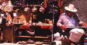
Street market, La Paz (24K)
Around La Paz is the aptly named Valle de la Luna, which is an eroded hillside maze of miniature canyons and pinnacles 11km (7mi) east of the city; the spectacular Zongo Valley, 50km (31mi) north of the city, which has ice caves, turquoise lakes and the peak of Huayna Potosí; and the historical ceremonial center of Tiahuanaco, 70km (43mi) west of the city, which is Bolivia's most important archaeological site.
Carved face, Tiahuanaco (9K)
Traditionally regarded as the highest navigable body of water in the world (in reality there are higher lakes in Chile and Peru), Lake Titicaca is immense: its dimensions measure 233km (145mi) from northwest to southeast and 97km (60mi) from northeast to southwest. The lake has an indented shoreline, 36 islands and exceptionally clear sapphire-blue water. Titicaca is revered by the Indians who live on its shores, and the Islas del Sol and Islas de la Luna, two islands in the lake, are the legendary sites of the Inca's creation myths. The main town in the area is Copacabana, which has a sparkling white Moorish-style cathedral and is host to the Fiesta de la Virgen de Candelaria. Isla Suriqui is world-renowned for its totora reed boats; Isla Kalahuta for its stone tombs; and Isla Incas is reputed in legend to have an underground network of passageways linking it to the old Inca capital of Cuzco in Peru.
Copacabana from Cerro San Collani (10K)
Travelers should wear protective head gear around the lake because the thin air results in scorchingly high levels of ultraviolet radiation. Half of the lake lies within the borders of Peru; Puno is the principal settlement and main center for excursions on the Peruvian shore of the lake.
Reputed to have the world's most perfect climate and Bolivia's most hardcore drinkers, the city of Cochabamba occupies a fertile green bowl in a landscape of fields and low hills. The city, founded in 1574, is Bolivia's largest market town and was once the nation's granary. It is still prosperous and progressive, and has a clutch of historical and archaeological attractions, including the 400-year-old cathedral, the Convento de Santa Teresa and the Museo Arqueológico.
Sorata
Often described as having the most beautiful setting in Bolivia, this sleepy town sits at an elevation of almost 2700m (8856ft) in a valley beneath the towering snowcapped peaks of Illampú (6362m/20,867ft) and Ancohuma (6427m/21,080ft). The lush valley and vegetation attract a steady stream of travelers, nearly all of whom fall in love with the place. Most visitors make the 10km (6mi) walk to Gruta de San Pedro to see the cave and underground lake.
Tupiza
Tupiza, located in the heart of some of Bolivia's most spectacular countryside, is a real gem for anyone who loves desert landscapes. It's a young, cultured city which lies in the narrow valley of the Río Tupiza. It is surrounded by the rugged Cordillera de Chichas, whose attractions include multi-hued rocks, mountains, chasms, clear rivers, cactus forests, brilliant skies and wide open spaces.
 Off the Beaten Track Off the Beaten Track
Salar De Uyini
This 12,000 sq km (4680 sq mi) saltpan at an altitude of 3650m (11,970ft) was once part of a prehistoric salt lake which covered most of southwestern Bolivia. Although estimated to contain 10 billion tonnes of fine salt reserves, the only harvesters of this resource are the local campesinos armed with nothing more than picks and shovels. Isla de Pescadores, in the middle of the saltpan, has spectacular stands of cactus and is home to a stranded colony of vizcachas (long-tailed rodents related to the chinchilla). The village of Uyini, southeast of the saltpan, is the best base for excursions. Northwest of Salar de Uyini is the Salar de Coipasa, on whose northern shore is a unique Chipaya Indian village. Residents of this village may be descendants of the lost Tiahuanaco civilization. If you travel this far off the beaten track, be sensitive to local culture; photography of people in this region is discouraged.
Salar de Uyini (12K)
This fiery, red lake in the far southwest of Bolivia is in a remote highland area surrounded by a surreal treeless landscape spotted with gentle hills that resemble spilt chocolate sundaes. Birdwatchers will be particularly interested in the rare James' flamingos which inhabit the lake. Temperatures drop below -20°C (-4°F), but the bitterly cold air is heavily perfumed with the scent of yareta - a shrub used as a fuel. Fifty kilometers (31mi) south of the lake is the 4800m (15,745ft) Sol de Mañana, where a geyser, bubbling mud pools and hellish fumaroles fart and belch stinky sulphurous fumes into the fresh mountain air.
Laguna Verde
This stunning blue-green lake situated at an elevation of 5000m (16,400ft) is tucked into the southwestern corner of Bolivia, almost 100km (62mi) from Sol de Mañana. Behind the lake rises the 5930m (19,450ft) cone of Volcán Licancabur, whose summit shelters an Incan crypt. If you get goosebumps up here, it may not just be the weather. Young Inca men were marched to the summit without protective clothing and forced to freeze to death as a sacrifice to the gods.
San Vicente
This one-mule village in the southern Altiplano would be of no particular interest if it were not the place where the legendary outlaws Butch Cassidy and the Sundance Kid supposedly met their demise at the hand of the Bolivian Army in 1908. There are several contending last resting places of this infamous pair, but if you buy into this version, then this should be a pilgrimage.
Rurrenabaque
This bustling little frontier settlement on the Río Beni, 300km (186mi) north of La Paz, is the loveliest of the Bolivian lowland villages. The original inhabitants of the area - the Tacana - were one of the few lowland tribes who resisted Christianity and Western-style civilization. The surrounding rainforest is abundant in Amazonian wildlife and jungle trips from the village are unbeatable.
 Activities Activities
Most of the popular treks begin near La Paz, traverse the Cordillera Real on ancient Inca routes, and end in the Yungas. The three-day La Cumbre to Coroico Trek, northeast of La Paz, is the premier hike in Bolivia. Other popular treks include the two-day Taquesi Trek, also known as the Inca Trail, which crosses a low pass in the Cordillera Real between Ventilla and Chulumani; the little-known Yunga Cruz Trek, between the village of Chuñavi and Chulumani, which passes over a shoulder of the mighty Illimani; and the six-day El Camino de Oro, or Gold Trail, which heads from Sorata to the Río Tipuani goldfields. The less strenuous walk to the Zongo Valley Ice Caves near La Paz is a spectacular alternative for those suffering cramps or needing to adjust gently to the high altitude. The Cordillera Real also offer great climbing opportunities, including Illimani, 6088m (19,970ft) Huayna Potosí, 5648m (18,525ft) Condoriri and the 6427m (21,080ft) Ancohuma. You can ski at the world's highest developed ski run atop a glacier on the slopes of Chacaltaya, near La Paz, or at nearby but less developed areas on Condoriri and Mururata.
Ski hut, Chacaltaya (10K)
When you've exhausted the mountains, jungle treks in the Amazonian Basin can be arranged in Rurrenabaque, El Porvenir (in the Reserva Biosférica del Beni), Perseverancia (in the Preseverancia and Reserva de Vida Salvaje Ríos Blanco y Negro) and in the remote but pristine Parque Nacional Noel Kempff Mercado in the northernmost reaches of Santa Cruz Department. River boats plying the Río Mamoré from Trinidad go into the heart of Bolivia's greatest wilderness area, enabling travelers to experience the mystique and solitude for which the Amazon is renowned.
Rainforest trek, Tío Tuichi (11K)
 Getting There & Away Getting There & Away
Only a limited number of airlines offer services directly to Bolivia and fares are high. Many people fly into another South American country, such as Argentina, Brazil, Colombia or Peru, and travel overland to Bolivia, which generally works out to be cheaper. Border crossing points include Villazón-La Quiaca and Yacuiba-Pocitos (Argentina); Quijarro-Corumbá and Guayaramerín-Guajarç-Mirim (Brazil); Charaña-Visviri and Abaroa-Ollagüe (Chile); Yunguyo-Puno and Desaguadero-Puno (Peru).
 Getting Around Getting Around
Domestic air services are provided by LAB, TAM and AeroXpress. Be prepared for delays, cancellations and general unreliability. Bolivia's road network is not good, mainly because of the lack of paved roads. Most long-distance buses depart in the evening and travel through the night. If you want to see the countryside between towns, you're better off catching a truck, a popular mode of transport among campesinos. Trucks are half the price of buses, but can be rough going. There are two rail networks: one in the west and one in the east. The eastern network is completely chaotic; the western network is just disorganised. Don't be fooled by trains called tren expreso and other zippy names; all trains apart from the ferrobus are excruciatingly slow. The Ichilo, Mamoré, Beni, Madre de Dios and Guaporé rivers are the main thoroughfares in the Amazon Basin.
 Recommended Reading Recommended Reading
- A Sick People (1909) and The Bronze Race (1919) by the positivist historian Alcides Arguedas are withering yet compassionate accounts of his country and its people.
- The Conquest of the Incas by John Hemming is the definitive work on the Spanish conquest of the ancient empire.
- Sir Arthur Conan Doyle's memorable The Lost World was inspired by tales of the northeastern Bolivian plateaux.
- At Play in the Fields of the Lord by Peter Mathiessen is a moral tale of missionaries in the Amazonian rainforests.
- Emperor of the Amazon by Brazilian Márcio Souza is a biting modern satire on the horrors of the Amazon and the absurdity of personal and governmental attempts to conquer it.
 Lonely Planet Guides Lonely Planet Guides
 Travelers' Reports Travelers' Reports
|


 On-line Info