Facts at a Glance Facts at a Glance
Area: 21 sq km (8 sq mi)
Population: 1200
Capital city: Oranjestad
People: Mixed African and European descent
Language: English, Dutch (official)
Religion: Roman Catholic, Protestant, Jewish, Seventh-Day Adventist
Government: Municipality of the Netherlands Antilles
Governor General of the Netherlands Antilles: Jaime Saleh
Lieutenant Governor of Sint Eustatius: E R Abdul
 Environment Environment
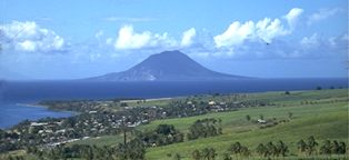
Shaped a bit like a gourd, Sint Eustatius is only 8km (5mi) long and 3km (2mi) wide. The island is 60km (37mi) south of Sint Maarten and 27km (17mi) southeast of Saba. Mt Mazinga, better known as 'the Quill' (whose name is derived from the Dutch word for volcano), is an extinct volcano rising 600m (1970ft) above the southern half of the island. Cliffs drop straight to the sea along much of the shoreline and the island has precious few beaches. At the northern side of Statia there are a few low mountains, while the island's central plain contains the airport and town. Statia has few roads and is easy to get around. Oranjestad, the island's sole town, is just south of the airport.
Most of the island is dry, with scrubby vegetation, although oleander, bougainvillea, hibiscus and chain of love flowers add a splash of color here and there. The greatest variety of flora grows on the slopes of the Quill, which collects enough cloud cover for its central crater to harbor a rainforest of ferns, elephant ears, bromeliads, bananas and tall trees. The island also has 18 varieties of orchids, all but three of which are found on the Quill. There are 25 resident species of birds on Statia, including white-tailed tropicbirds nesting on the cliffs along the beach north of Lower Town. There are also harmless racer snakes, iguanas, lizards and tree frogs - along with the ubiquitous goats, cows and donkeys.
In January the average daily high temperature is 29°C (85°F); it averages a few degrees warmer in July and rarely dips below 22°C (72°F). Moderate rainfall is fairly evenly dispersed throughout the year.
 History History
The Caribs called the island Alo, which means cashew tree, while Columbus named the island after St Anastasia. Although the French began construction of a fort in 1629, the first permanent settlement wasn't established until the Dutch routed the French in 1636. Statia subsequently changed hands 22 times between the Dutch, French and British.
In the 18th century, as the British and French buried their colonies in taxes and duties, the Dutch turned Statia into a duty-free port. As a result, West Indian and North American colonies were able to circumvent duties by shipping goods via Statia, which boomed into a thriving entrepôt and a major trade center between the Old and New worlds. During its heyday in the 1770s, as many as 300 trading ships pulled into port each month and the island's population swelled to 20,000. The resulting prosperity earned Statia the nickname 'Golden Rock of the Caribbean.'
Rather inadvertently, became the first foreign land to recognize the American colonies' Declaration of Independence by returning a cannon salute to the passing American war brig Andrew Doria. Unfortunately for Statia, another American vessel went on to capture a British ship in nearby waters, prompting the British to attack Statia, ransack the warehouses, exile the island's merchants and auction off their goods. The Dutch regained possession of the island a few years later but the British invasion marked the end of Statia's predominance as a trade center.
Ironically, US independence and the signing of a peace treaty between the US and Britain in 1783 allowed the former American colonies to establish more direct trade routes and bypass Statia altogether. To this day Statia remains well off the beaten path of travelers - though not of hurricanes. Hurricane George caused extensive damage (but, luckily, no fatalities) on the island in 1998.
 Economic Profile Economic Profile
GDP: US$2 billion for Netherlands Antilles as a whole
GDP per head: US$10,000
Growth rate: 0%
Inflation: 3%
Major industries: Government administration, fishing, retail, tourism
Major trading partners: USA, Venezuela, Columbia, Netherlands, Japan
 Culture Culture
The majority of the people are of African descent, largely the descendants of slaves brought to Statia to work in the warehouses in Lower Town and on a handful of long-vanished plantations. The culture is a mix of African and Dutch heritage. The lifestyle is casual, but a bit more conservative than on neighboring islands - bathing suits are frowned upon outside of beach areas and hotel pools.
There are Methodist, Roman Catholic, Seventh-Day Adventist, Anglican, Baptist, Apostolic and Baha'i churches on Statia. While Dutch is the official language, English is most commonly spoken.
 Events Events
The Statia Carnival, which is held during mid-July and culminates on a Monday, is the island's biggest festival. Music, jump-ups, competitions and local food are the highlights. Fort Oranje is the site of ceremonies held on Statia-America Day, 16 November, which commemorates the date in 1776 when Statia became the first foreign land to salute the US flag.
Public Holidays
1 January - New Year's Day
Easter Holidays - Good Friday, Easter Monday
30 April - Queen's Day
1 May - Labor Day
40th day after Easter - Ascension Thursday
August - Carnival Monday
November - Statia/America Day
25 December - Christmas Day
26 December - Boxing Day
 Facts for the Traveler Facts for the Traveler
Visas: US and Canadian citizens don't need visas or passports, only proof of citizenship.
Health risks: Sunburn
Time: Atlantic Standard Time (GMT/UTC minus 4 hours)
Electricity: 110V, 60Hz
Weights & measures: Metric (see the conversion table).
Telephone: 599-3
 Money & Costs Money & Costs
Currency: Netherlands Antilles florin (NAf)
Relative costs:
Budget meal: US$5-10
Moderate restaurant meal: US$10-30
Top-end restaurant meal: US$30 and upwards
Budget room: US$40-55
Moderate hotel: US$55-75
Top-end hotel: US$75 and upwards
Comfortable travel is more reasonably priced on Sint Eustatius than on most Caribbean islands; expect to spend US$150-200 a day, depending on dive trips and car rentals. Those whose pursuits lean to the frugality of footing it up the mountain will spend closer to US$100 a day. Self catering can keep your costs closer to US$60 a day or less.
US dollars and travelers' checks are accepted nearly everywhere; you can use credit cards at car rental agencies, larger hotels and a few shops.
There's a 7% accommodation tax in Statia and hotels tack on a 10% to 15% service charge. Restaurants add 10% or 15%.
 When to Go When to Go
Statia is comfortably warm all year, though prices are lower during the summer months (December to February), when most potential visitors (ie, North Americans) tend to keep to their own latitudes.
 Attractions Attractions
Oranjestad
Oranjestad, the island's capital and its only town, is a pleasant place with a fine sense of history. Located along the waterfront, Lower Town was the location of the original port town and still has some ruins from the colonial era, as well as the island's best beach and its harbor. Upper Town is Oranjestad's main commercial and residential area.
Right in the center of town, Fort Oranje is an intact 17th century fort complete with cannons, triple bastions and a cobblestone courtyard. It's perched on the cliffside directly above Lower Town and offers a broad view of the waterfront below. The Sint Eustatius Museum, operated by the Sint Eustatius Historical Foundation, gives visitors a glimpse of upper-class colonial life on Statia and is one of the region's finest historical museums. It occupies the Simon Doncker House, a restored 18th-century Dutch merchant's home with collections of nautical artifacts, china and hand-blown bottles. The basement, formerly a wine cellar, houses the museum's pre-Columbian collection.
The Honen Dalim, an abandoned synagogue that dates from 1739, is the second oldest in the western hemisphere. About half a kilometer east of the synagogue ruins is a Jewish cemetery with gravestones dating from 1742 to 1843. The thick stone walls of the old Dutch Reformed Church, built in 1755, remain perfectly intact, but the roof collapsed during a 1792 hurricane and the building has been open to the heavens ever since. You can climb the steep steps of the church tower for a good view of the surrounding area.
Although high seas and hurricanes have taken their toll on Lower Town's historic waterfront, the remains of the old foundations from some of the 18th-century warehouses that once lined the coast can still be seen jutting into the water along the shore. Submerged sections of the old seawall that once protected the harborfront can be explored by donning a mask and snorkel.
The road south from Oranjestad ends abruptly at Fort de Windt, where a couple of rusty cannons sit atop a cliffside stone wall. While there's not much else to this small 18th-century fort, you'll be rewarded with a fine view of St Kitts to the southeast. The most interesting geological feature in the area is the white cliffs to the east of Fort de Windt, a landmark readily visible from neighboring islands.
The fort just southeast of Oranjestad. To get there, take the road that runs past the old Dutch Reformed Church and follow it south, through a dry terrain of cacti and stray goats, to its end 3km (2mi) away.
 Off the Beaten Track Off the Beaten Track
Zeelandia
Zeelandia, 3km northeast of Oranjestad, takes its name from Statia's first Dutch settlers, who were from Zeeland province in the Netherlands. It's a nice spot for a stroll, though the dark-sand beach at Zeelandia Bay collects a fair share of flotsam and is not a good beach for swimming. You can find private niches by walking south along the beach towards the cliffs.
If you're up for a longer walk, a track from the main road leads north to the semi-secluded Venus Bay. There's no beach, but it makes for a nice hike, taking about 45 minutes each way.
 Activities Activities
No one visits Statia for its beaches, which are few in number and undistinguished. The island's best beach for swimming is the usually calm Oranje Beach in Lower Town. Zeelandia Bay on the east coast, which has rough surf and undertows, is not recommended for swimming but nonetheless rates as Statia's second beach. Oranje Beach, at the north end of Lower Town, has gray sands and generally calm waters. Modest as it may be, it's the island's best all-round beach and a popular swimming spot for Statian families.
Statia has a couple dozen dive sites, the majority of which are coral formations on old lava flows. There are also a few wrecks of colonial trading ships, although the remains are basically piles of ballast stones as the ships themselves have disintegrated. To protect the island's historical remains from souvenir hunters, all divers are required to be accompanied by a guide. The Stingray wreck (1768), a few minutes from Lower Town in 15m (50ft) of water, is near a ledge with a rich concentration of marine life, including stingrays, spotted eels and octopuses.
Anchor Reef, at the southwest side of the island, is a popular reef dive with a wide variety of sponges, corals and sea fans. It also has many ledges and crevices harboring lobsters, sea turtles and numerous species of fish. For a deep dive, Doobie Crack, a large cleft in a reef at the northwest side of the island, has black-tip sharks and schools of large fish.
Inexpensive snorkeling tours of some of the shallower reefs are available from the dive shops.
Statia has good hiking, and its most popular trail leads to the rim of the Quill, an extinct volcano. The trail begins in Oranjestad and takes about 50 minutes to reach the edge of the crater. From there you can continue in either direction along the rim. The trail to the southeast takes about 45 minutes and ends atop the 600m (1970ft) Mazinga, Statia's highest point. The shorter Panorama Track to the northeast offers spectacular views and only takes about 15 minutes. A third option is the steep track leading down into the crater, where there's a thick rainforest of tall trees, some with huge buttressed trunks. This track takes about 30 minutes each way.
 Getting There & Away Getting There & Away
The only scheduled flights to Statia are with Winair, which has several flights a day from Sint Maarten. Winair also has a daily flight between Statia and Saba.
Statia's harbor includes an anchorage for visiting yachts. Yachties should check in with the harbormaster upon arrival. Windjammer Barefoot Cruises' schooners and a few other small cruise ships also visit the island.
For stays of more than 24 hours, there's a departure tax of US$5 for flights within the Netherlands Antilles, US$10 to other destinations.
 Getting Around Getting Around
Statia has no buses, so renting a car is useful if you want to explore the island properly. If you're staying in Oranjestad, you probably won't need a car for most of your stay but expect to do some serious walking as the town is spread out.
You can rent a car at the airport or in town. Your home driver's license is valid for driving on Statia. By Caribbean standards Statia's roads are good, albeit sometimes narrow, and you need to watch out for stray animals on the road. Drive on the right-hand side of the road.
There are usually one or two taxis on hand to meet flights at the airport, which is about a kilometer northeast of town.
 Recommended Reading Recommended Reading
- Archaeology of St. Eustatius, edited by Aad H. Versteeg & Kees Schinkel, digs into the island's past.
- Ronald Hurst's The Golden Rock: An Episode of the American War of Independence, 1775-1783 details Statia's role in the revolution.
 Lonely Planet Guides Lonely Planet Guides
 Travelers' Reports Travelers' Reports
 On-line Info On-line Info
|