Facts at a Glance Facts at a Glance
Area: 13 sq km (5 sq mi)
Population: 1200
Capital city: The Bottom
People: Mixed African descent (85%), Amerindian, European descent
Language: Dutch, Papiamento, English
Religion: Roman Catholic, Protestant, Jewish, Seventh-Day Adventist
Government: Municipality of the Netherlands Antilles
Governor General of the Netherlands Antilles: Jaime Saleh
Lieutenant Governor of Saba: S A E Sorton
 Environment Environment
Saba is located about 1970km (1225 miles) southeast of Miami, Florida, and 310km (195 miles) east of San Juan, Puerto Rico, near the northern end of the Lesser Antilles. The island forms the westernmost corner of a triangle of islands including Sint Maarten (46km/28mi northeast) and Sint Eustatius (32km/20mi southeast). It's virtually impossible to get lost on Saba. There is only one main road, which runs from the airport at the northeastern side of the island through the villages of Hell's Gate, Windwardside, St John's and the Bottom, and continues down to Fort Bay, the island's main port. A second road connects the Bottom with Well's Bay on the island's northwestern side.
Shaped a bit like a heart (think anatomically, not Valentine's), Saba's land area is small, but because of its topography of folding mountains the island is far more substantial than any mere area measurement would indicate. As the tip of an immense underwater mountain, the island juts out of the sea with no pause for lowlands or beaches. Saba's central volcanic peak, Mt Scenery, is 890m (2900ft), its summit cloaked in clouds.
There are no rivers or streams on the island. The leeward (western) side is dry with cacti and scrub, the windward (eastern) side has thicker vegetation and the mountainous interior is given over to lush jungle growth such as tall tree ferns, palms and mahogany trees.
Saba has a wide variety of flowering plants, ranging from the prolific oleander and hibiscus that decorate its yards to the wildflowers and orchids that thrive in the rainforest. Over 60 species of birds are sighted on Saba, including bridled and sooty terns, brown noddys, tropicbirds on the cliffs and frigatebirds near the coast. Red-tailed hawks can be spotted on the lower slopes, while thrashers and hummingbirds are found at higher elevations. Saba is crawling with harmless racer snakes that sun themselves along trails and roadsides. Expect to see the friendly little Anolis sabanus lizard that's endemic to the island and to hear the tiny tree frogs whose symphony can be almost deafening at night.
The average monthly temperature is 27°C (80°F), with few degrees difference between summer (June to August) and winter (December to February). Because of the difference in elevation, temperatures are a bit cooler in Windwardside than in the Bottom.
 History History
Because of the island's rugged terrain, Saba was probably not heavily settled in pre-Columbian times. However, artifacts uncovered in the Spring Bay area indicate the existence of a small Arawak settlement at that site about 1300 years ago.
During his second trip to the New World, in November 1493, Christopher Columbus became the first European to sight Saba. The Dutch laid claim to the island in 1632 and sent a party of colonists from Sint Eustatius in 1640 to form a permanent settlement. These early colonists originally lived at Middle Island and Mary's Point, where a few cisterns and stone walls can still be found, but soon moved to the Bottom, which remains the administrative center of the island.
As the steep topography precluded large-scale plantations, colonial-era slavery was quite limited on Saba. Those colonists who did own slaves generally had only a few and often worked side by side with them in the fields, resulting in a more integrated society than on larger Dutch islands.
Until the 1940s, Saba's villages were connected solely by footpaths. When Dutch engineers told residents the island's steep terrain prohibited roadbuilding, they spent the next 20 years building one themselves. Although Hurricane Georges rolled directly over the island in 1998, no one was killed and damage was relatively light.
 Economic Profile Economic Profile
GDP: US$2 billion for Netherlands Antilles as a whole
GDP per head: US$10,000
Growth rate: 0%
Inflation: 3%
Major industries: Tourism
Major trading partners: USA, Venezuela, Columbia, Netherlands, Japan
 Culture Culture
Saba's population is composed mainly of descendants of African slaves; there are also many descendants of the early Scottish, Irish and Scandinavian settlers. Most people can trace their lineage to one of half a dozen families, and just two names, Hassell and Johnson, account for almost a third of the phone-book listings. Incidentally, despite its Dutch government, Saba is home to very few people of Dutch descent.
Catholicism is the predominant religion on Saba, but the island's eight churches also include Anglican, Wesleyan Holiness and Seventh-Day Adventist denominations.
Although Dutch is the 'official' tongue, English is the primary language of the island and the one most commonly spoken in the home. To accommodate this reality, the Dutch government recently allowed the Saban school system to switch from Dutch to English as the principal classroom language.
 Events Events
The Saba Summer Festival, held in late July, is the island's Carnival. The week-long event includes jump-ups, a queen contest, a calypso king competition, a costumed parade around the Bottom and a grand finale fireworks display. Saba Days, held in early December, features sporting events, steel bands, dancing, donkey races and barbecues.
Public Holidays
1 January - New Year's Day
Easter Holidays - Good Friday, Easter Monday
30 April - Queen's Day
1 May - Labor Day
40th day after Easter - Ascension Thursday
25 December - Christmas Day
26 December - Boxing Day
 Facts for the Traveler Facts for the Traveler
Visas: US and Canadian citizens don't need visas or passports, only proof of citizenship.
Health risks: Sunburn
Time: Atlantic Standard Time (GMT/UTC minus 4 hours)
Electricity: 110V, 60Hz
Weights & measures: Metric (see the conversion table).
Telephone: 599-4
 Money & Costs Money & Costs
Currency: Netherlands Antilles florin (NAf)
Relative costs:
Budget meal: US$5-10
Moderate restaurant meal: US$10-30
Top-end restaurant meal: US$30 and upwards
Budget room: US$35-75
Moderate hotel: US$75-150
Top-end hotel: US$150 and upwards
Those on a top-end budget will be shelling out US$200 or more a day; fancy accommodations and full-service dive packages will inflate push that higher. Moderate costs can run to US$150 a day or more. Budget travelers can spend less than US$100 a day by self-catering accommodations and strolling or hiking more than diving. Note that accommodation is much cheaper in the quieter summer months and that organizing your own diving excursions is more expensive than taking the dive packages offered by many hotels and resorts.
US dollars and travelers' checks are widely accepted, as are credit and debit cards. There's generally no advantage to changing your money to florins unless you're planning a lengthy stay. What few banks there are, are in Windwardside. Credit cards are accepted at most hotels and some restaurants.
Hotels add a 5% room tax to your bill, and many tack on a service charge of 10%; restaurants add 10% or 15%. Islander-geared businesses such as grocers and shops post their prices in florins; most everyone else posts prices in US dollars.
 When to Go When to Go
A comfortably warm year-round temperature makes Saba a good stop any time, though prices are lower during the summer months (December to February), when most potential visitors (ie, North Americans) tend to stay away from the tropics.
 Attractions Attractions
Windwardside
The island's largest hamlet, Windwardside has curving alleyways lined with picturesque cottages and flower-filled gardens. Being on the windward side of the island, just below Mt Scenery, this hillside village is lush and green and a tad cooler than other parts of the island.
Windwardside makes the best base for visitors, as it has the most hotels, restaurants and shops, as well as the tourist office, the museum, a good art gallery and the trailhead to Mt Scenery. While walking around you'll probably notice that many homes have Dutch doors, the top halves of which are commonly kept open in the evening, allowing people to chat from their living rooms with neighbors strolling by.
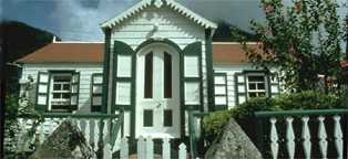
The Saba Museum is in a garden-like setting surrounded by wildflowers, including black-eyed susans, the official island flower. The museum is in a typical Saban home, whitewashed with green-shuttered windows, and re-creates the living quarters of a 19th century Dutch sea captain. There's a four-poster bed with period decor, a collection of pottery fragments, Amerindian hand tools and lots of memorabilia, including maritime documents, sextants and a compass.
Windwardside is just east of the middle of the island, about halfway between Hell's Gate and the Bottom, and connected to each by road.
The Bottom is Saba's administrative center, but beyond that it's a quiet, lovely town. As you first enter, you'll come upon the Department of Public Works, a former schoolhouse flanked by tall night-blooming cacti that give off a wonderful fragrance in the evening. On the next corner is the Anglican Church, a picturesque stone structure more than 200 years old. The town also has a couple of cobblestone streets lined with old stone walls.
The Bottom is located in the southwest corner of the island. A kilometer-long road leads to Fort Bay, the island's commercial port, on the southwestern coast. This winding section of road leads down through dry terrain punctuated by Turk's-head cacti. Fort Bay has dive shops, the marine park office, the island's power station, a water desalination plant and Saba's only gas station and hyperbaric chamber. While there's no beach at Fort Bay, it's possible to join the local kids swimming at the pier.
The island's premier hike is to the top of Mt Scenery, a strenuous climb up a virtual nonstop run of stairs (1064 in all) that ends at the highest point in the Kingdom of the Netherlands. The clearly marked trail begins at the side of the road a short walk west of the tourist office in Windwardside. Hiking time is about 2-1/2 hours roundtrip. If you rise early enough, the summit is a great place to watch the sun come up.
As ample reward for a good workout, you'll get a close-up view of an elfin forest with its lush growth of ferns, tropical flowers and epiphyte-covered mahogany trees, and if clouds don't roll in, the summit provides panoramic views of Saba and neighboring islands. There are interpretive signboards along the trail and a few shelters for shade - though it can get very hot a midday so be sure to bring water. After reaching the summit, be sure to continue along the left side of the radio tower to reach a scenic lookout 100m (330ft) beyond.
For a quick sense of what Saban wilderness is like, take the 45-minute roundtrip hike to Maskehorne Hill. After about 10 minutes of climbing old stone steps through a forest thick with tall elephant ears and birdsong, you'll reach a small dasheen farm. At the farmer's hut, turn left off the Mt Scenery Trail onto the Maskehorne Hill Trail, a dirt path through the forest that continues to nearby Maskehorne Hill and a view of Windwardside.
 Off the Beaten Track Off the Beaten Track
Hell's Gate
When you stand at the airport and look up the mountain, you see the village of Hell's Gate, whose houses seem to cling precariously to the slopes. The road from the airport to Windwardside passes directly through the village.
The main landmark in Hell's Gate is the Holy Rosary Church, a seemingly old stone church built just three decades ago. Behind the church, Hell's Gate Community Center sells the best collection of Saba lace on the island as well as bottles of homemade Saba Spice liqueur.
The ride from Hell's Gate to Windwardside is steep and winding. It passes through a variety of terrains, offering some fine scenic views of Saba itself and glimpses of the neighboring islands of Sint Eustatius, St Kitts, Nevis and St Barts.
Although the waters off Saba's east coast are often turbulent, Cove Bay, near the airport, has a little boulder-protected pool that provides a safe spot for cooling off on a hot day. The bay is reached after a five-minute walk along the side road that begins just outside the terminal.
Along the road into Cove Bay, there's a signposted trail leading from an old leather factory (now a classroom for medical students) out along coastal bluffs to some nice tidal pools at Flat Point, behind the airport. The hike takes about 15 minutes each way.
 Activities Activities
Saba's stunning scenery extends beneath the surface, with steep wall drops just offshore and some good nearshore reef dives. Most of the island's two dozen dive spots are along the calmer leeward (western) side, between Tent Bay on the south and Diamond Rock on the north.
Some of the more exciting dives include Tent Reef Wall, which has colorful tube sponges and corals and lots of fish activity; Third Encounter, where the coral and sponge-encrusted, 75m (250ft) tall 'Eye of the Needle' towers above the floor; and Diamond Rock, which has a great variety of marine life, including stingrays, black-tip sharks and bull sharks.
For snorkelers, Well's Bay and the adjacent Torrens Point are popular spots, and there's even a marked underwater trail.
The waters surrounding Saba are protected under the auspices of the Saba Marine Park, which has undertaken a number of conservation efforts, including installing permanent mooring buoys at dive sites. To help cover the park's operating expenses, a small marine park fee is added onto each dive.
Saba is not the place to go if you want to lay out on sandy strands. The main swimming spot is Well's Bay at the northwestern side of the island, which has a small, rocky beach. All the island hotels have swimming pools.
Saba has excellent hiking. There are seven signposted hikes, ranging from a 15-minute walk to tide pools just beyond the airport to a steep climb up through a cloud forest to the top of Mt Scenery, Saba's highest point. Some of the trails, such as the Crispeen Track between the Bottom and Windwardside, follow the old footpaths that linked the villages before the first vehicle roads were built. A trail brochure and map is available free at the tourist office in Windwardside.
 Getting There & Away Getting There & Away
The only scheduled flight service to Saba is with Winair, which has several flights a day from Sint Maarten, a 15-minute hop. Winair also has a daily flight from Sint Eustatius and weekly flights from St Barts.
Saba does not have a deep-water port capable of handling large cruise ships. However, Windjammer Barefoot Cruises and a few other small ships stop over at Saba by anchoring in Fort Bay and bringing passengers ashore by dinghy. Two motorized catamarans run between Sint Maarten and Saba's Fort Bay.
The island has two designated anchorages for yachties: the harbor at Fort Bay and the area from Well's Bay to Ladder Bay. To help support the Saba Marine Park, there is a small yacht visitor fee per person. People arriving by boat should first clear immigration at the harbor office at Fort Bay.
The departure tax, for people aged two and older, is US$2 for those going to a Netherlands Antilles island and US$10 for those who aren't going to another Dutch island.
 Getting Around Getting Around
There are no public buses and no scooters or bicycles for rent on Saba, which makes taxis (or your feet) the best way to go. Taxis usually meet flights; fares are fixed by the government.
Saba has very narrow and steep roads that may intimidate some drivers. Even Sabans are challenged by tight corners in Windwardside - you'd be hard pressed to find a car that doesn't bear scrape marks from kissing at least one stone wall! If you must have your own wheels, remember that there aren't many rental cars on the island so try to book in advance. The main rental outlets are in Windwardside. Your home driver's license is valid on Saba. The island's sole gas station is in Fort Bay. Drive on the right side of the road.
Hitchhiking is a common means of transportation. In Windwardside, the main hitching spot is near the wall by the Big Rock Market; in the Bottom it's by the Department of Public Works.
 Recommended Reading Recommended Reading
- Guide to the Saba Marine Park, by marine biologist Tom van't Hof, is an authoritative guide to underwater Saba. Van't Hof, who spearheaded the development of the Saba Marine Park, gives detailed descriptions of each of Saba's 26 dive sites, accompanied by color photos illustrating coral and marine life.
- Saban Cottages, a coffee table book by artist Heleen Cornet, contains watercolor drawings of scores of the island's picturesque buildings.
 Lonely Planet Guides Lonely Planet Guides
 Travelers' Reports Travelers' Reports
 On-line Info On-line Info
- Take the subWWWay to Saba
|