 Bonnieux
Provence-Beyond (Beyond the French Riviera) ®
Vaucluse (84480)
Population: 1422
Altitude: 420 m
Nearby:
[ Apt 12 km | Cavaillon 24 | Goult 7 | Fort de Buoux | Lacoste 5 | Luberon | Ménerbes 9 | Oppède 13 | Pont Julien ]
Photos:
A larger view of the village (15k)
The "Eglise Haute" at the top of the village (27k)
Below: [ History | Dates-Numbers | Transportation | Wine | Cycling | Hiking | Lodging ]
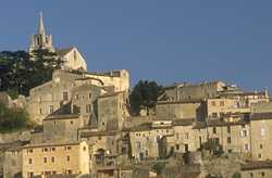 The village of Bonnieux is perched on a narrow, steep ridge, rising up from a flat plain to the 12th-century "Eglise Haute " church at the top with its high, pointed steeple.
Access to this "vieille église" is via 86 steps going up from the village. Take a fast hike from bottom to top, winding up through the narrow streets passing in arched tunnels beneath the houses, up the 86 steps, and you'll earn the spectacular view, shaded by tall pine trees and magnificent centuries-old cedars. Just out of the village to the east, you'll find signs along the road to the Fôret de Cèdres (cedar forest).
A lovely little park with lush green grass is hidden out past the end of the high church at the top and has a view of the gorges cutting through the Luberon to the south, behind the village. The newer "église neuve" church with its high, pointed steeple sits prominently out on the slope in front of the lower village. This fine church is considered "new" because it was built just yesterday, in 1870.
A road also winds back and forth up through the village, passing small squares with shops and cafés at different levels. There are a number of small shops with pottery, artisanal items, and one with beautiful hand-woven wool items. The shops are spread out enough to be unobtrusive.
The view from Bonnieux is out over plains, with vineyards, fields and cherry orchards. Further in the distance you can see tiny medieval villages.
In a two-star hotel high in the village you can sit on the private terrace of your room and watch the sun set behind the neighboring village of Lacoste. Of course you need to get up early enough in the morning to watch the rising sun light the village up again.
Name
First record, 1103: Castrum Bonils
History
Prehistoric: There are many neolithic signs at and around Bonnieux, including several shelters and tombs.
Gaulois: Gaulois villages of the "Vulgientes"
Roman: the Roman road Domitienne Way (Voie Domitienne) passes Bonnieux to cross the Calavon at the Pont Julien, one of the most beautiful Roman bridges in France.
Medieval: a monastery in the 6th century (on the site of a pagan temple);
part of the Comtat Venaissin; abandoned in the 13th century; Knights Templiers
- Dates, Numbers
- Market day: Friday
- Fête votive: first Sunday 15 Aug.
- Office de Tourisme
- Tel: (33) 490 75 91 90; Fax: (33) 490 75 92 94
- Open: Tue-Sat, 10h30-12h30, 14h30-18h30
Bread Museum
Bonnieux has Beyond's only bread museum, the Musée de la Boulangerie. The museum displays a period bread oven and bread shop, not so much different than what you see in today's small boulangeries (although they are steadily disappearing with the encroachement of the massive "bread factories").
The Bonnieux Musée de la Boulangerie is in a 17th-century house, perfectly natural for this ancient village.
Transportation
The Apt--Cavaillon bus runs along the N100 road. The nearest stop is at the junction of the D149 and the N100, by the Pont Julien, about 5 km north of Bonnieux. You should get the current schedule from the Office de Tourisme in Apt or Cavaillon. During the summer (1997) the bus towards Cavaillon stops at 8h40, 12h40, 16h40 and 18h10.
Wine
Apt is in the region of the Rhône Valley Côtes de Luberon wines.
Cycling
The Luberon en Vélo cycling path runs 100 km between Cavaillon, Apt and Forcalquier.
- Hiking
- Maps:
- IGN "bleue" (1:25,000) 3142 est "Apt, Bonnieux"
- Didier Richard (1:50,000) #14 "Luberon"
-
 The GR97 (Grande Randonnée) passes through the center of the Luberon mountains south of the Bonnieux.
A hiking trail south from the village goes into the Luberon to join the GR97.
A hiking trail north from Bonnieux crosses fields and a few low hills to join the GR6 near Roussillon, about 10 km away.
The GR97 (Grande Randonnée) passes through the center of the Luberon mountains south of the Bonnieux.
A hiking trail south from the village goes into the Luberon to join the GR97.
A hiking trail north from Bonnieux crosses fields and a few low hills to join the GR6 near Roussillon, about 10 km away.