 Fort de Buoux
Citadelle du Luberon "Clau dau Leberon"
Provence-Beyond (Beyond the French Riviera) ®
Vaucluse (84)
Altitude: 550 m
Nearby:
[ Apt | Bonnieux | Lourmarin | Luberon ]
Photos:
Watchtower viewed from inside the "baume" (13 k)
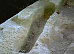
A 9th-century tomb carved in solid rock (24 k)
A series of stone tombs beneath the trees (32 k)
The steps to the fortress, carved from stone (32 k)
Cave-side dwellings in Chantebelle (27 k)
Rock climbers on the canyon cliffs (25 k)
Below: [ Caves | Tombs | Fortress | Cheese | Hiking | Climbing ]
The magnificent ruins of the Fort de Buoux are on top of a high stone butte in the Luberon mountains, about 10 km south of Apt and 8 km east of Bonnieux, overlooking the deep ravines of the Aigue Brun river. There are parking places past the "colonie de vacances", just off the little D113 road, and it's only about a 15-minute hike up to the start of the fort.
Prehistoric Caves
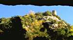 The short hike takes you past the largest "baume" in the Luberon (a natural cave beneath overhanging cliffs). Human habitation here and in other caves in the surrounding cliffs date back to prehistoric times, and has continued throughout history to the present. (The photo is a view looking out of the "baume".)
Stone Burial Tombs
 Where the trail passes in front of the huge "baume" on the right, the jumble of boulders on the left retain individual burial tombs carved into the solid rock. About a hundred of the stone sarcophagi remain here, of which a couple of dozen can be readily seen by clambering over the rocks. Each individual sarcophagus is carved to the size of the intended occupant, giving them a particularly poignant feeling. Some more of the stone tombs at a tiny road junction further up the valley (photo, 32k).
These sarcophagi date back to the 9th century at the latest. The necropolis served the town of Saint-Germain, which was completely destroyed in the 9th century in the wars between the Francs and the Saracens (history).
The Fortress
Past the "baume" you can see a round tower high on the cliffs (top photo, above) -- this is a watchtower on the lowest part of the citadelle. The narrow trail starting up the front of the forested cliff wall passes through the front yard of the "Guardien's" house, and the 10F fee is very reasonable for the discovery that awaits.
The trail continues to the "top", past steps carved from solid rock, fortifications and habitations. At the top are signs of ancient life, with deep trenches, vaulted cisterns (minus the tops), and other signs of building, both of shaped stone and carved in the solid rock itself. The view from the end, out over the deep valleys is magnificent.
The top of the butte slopes up, but most is hidden from view by low trees and shrubs. Hiking further you pass the ruins of a primitive village and the more recent ruins of a 13th-century church that was once protected by a succession of six walls. Beyond the church are signs of other ancient habitations, and a bunch of protohistoric grain silos carved down into the stone of the mountain.
Then the real defenses begin. Deep trenches and thick, arrrow-slitted walls span the width of the butte, forming the front of the fortress. A second trench and second wall are backed by a third trench and third wall, with a 13th-century fortified house behind. A bit further up the slope, where the top of the butte narrows, is a final deep ditch and a final thick wall, where the entrance was once over a drawbridge. The donjon at the top (finally) was originally Gallon-Roman, but Celtic-Ligurian vestiges remain here as well.
The view from this higher "top" is even more magnificent, and the narrowness of the fortress here accentuates the sensation.
Careful! The edges of this high butte drop straight down a very long way, and there's nothing near the edges, except gravity. The view is magnificent, but caution is emphasized, and bringing small children is not recommended.
Goat Cheese - Chantebelle
(Photo of the Chantebelle cliff-side dwellings - 27 k)
At the tiny rock village of Chantebelle, on a high ridge above the Aiguebrun river, you can buy fresh goat cheese (fromage de chèvre) from the small dwellings built into the cliff wall. Tasting, and buying, is by reservation:
tel: (33) 490 74 55 36.
- Hiking
- Maps:
- IGN "bleue" (1:25,000) 3142E "Apt, Bonnieux"
- Didier Richard (1:50,000) #14 "Luberon"
-
The GR 9 (Grande Randonnée) passes through the village of Buoux, and crosses the Aiguebrun about a km up the valley from the Fort, at Seguin. To the north, the GR 9 goes through Apt and then past St. Saturnin-lès-Apt and on the Plateau de Vaucluse. To the south, the GR 9 crosses the Luberon mountains to Vaugines, with branches to Lourmarin and Cucuron.
A great 3-hour hike. Excluding a couple of hours to visit the fort, there's an excellent loop hike along the sides of the Aiguebrun valley. It's about 3h20, but you'll want extra time to visit things along the way. This route is also possible for cycling (VTT). From the metal gate at the exit below the Fort, follow the road towards the Auberge de Seguin. Through the trees to the left you'll have a good view of rock climbers on the cliffs opposite. Where the road splits (Auberge de Seguin to the left), you'll keep to the right towards the Vallon de l'Aiguebrun. In the center of the junction are some more of the stone tombs (photo, 32k).
In a grassy clearing, where the "road" turns sharp right, you continue straight onto the footpath towards Chantebelle. This path, with a magnificent view over the valley, was part of the Route du Sel, the "Salt Road", or "Lou camin salié" in Provencal. Just a few minutes up this path (and only 25 minutes from the start at the fort) is a stone pillar standing sentinel over a great view of the valley, and down to troglodyte dwellings at the base of a side canyon.
The trail continues up the side valley to the tiny rock village of Chantebelle. Goat cheese can be obtained in the low buildings built into the side of the rock, but call ahead first. Follow the path to the left, circling the hilltop around Chantebelle.
The lovely little village of Sivergues is about 1h20 from the start, and you'll want to take some time to rest here and visit the village, from the modern troglodyte houses to the ancient "Fort de l'Archidiacre", now a gîte.
From Sivergues, take the trail down the hill northwest into the Aiguebrun valley. At the bottom, with "baume" caves beneath the cliffs, the trail follows down river through the trees. After about 0h55, the trail joins the GR 9. Follow the GR up the side of the hill out of the canyon, then west along the top, beside the oak-tree truffle plantations and lavender fields. When the GR turns right, continue straight on, eventually looping up past Deyme and joining the D113 road below Buoux. Follow the road back down to the starting point below the Fort, about an hour after joining the GR next to the river.
From the metal gate at the exit below the Fort, follow the road towards the Auberge de Seguin. Through the trees to the left you'll have a good view of rock climbers on the cliffs opposite. Where the road splits (Auberge de Seguin to the left), you'll keep to the right towards the Vallon de l'Aiguebrun. In the center of the junction are some more of the stone tombs (photo, 32k).
In a grassy clearing, where the "road" turns sharp right, you continue straight onto the footpath towards Chantebelle. This path, with a magnificent view over the valley, was part of the Route du Sel, the "Salt Road", or "Lou camin salié" in Provencal. Just a few minutes up this path (and only 25 minutes from the start at the fort) is a stone pillar standing sentinel over a great view of the valley, and down to troglodyte dwellings at the base of a side canyon.
The trail continues up the side valley to the tiny rock village of Chantebelle. Goat cheese can be obtained in the low buildings built into the side of the rock, but call ahead first. Follow the path to the left, circling the hilltop around Chantebelle.
The lovely little village of Sivergues is about 1h20 from the start, and you'll want to take some time to rest here and visit the village, from the modern troglodyte houses to the ancient "Fort de l'Archidiacre", now a gîte.
From Sivergues, take the trail down the hill northwest into the Aiguebrun valley. At the bottom, with "baume" caves beneath the cliffs, the trail follows down river through the trees. After about 0h55, the trail joins the GR 9. Follow the GR up the side of the hill out of the canyon, then west along the top, beside the oak-tree truffle plantations and lavender fields. When the GR turns right, continue straight on, eventually looping up past Deyme and joining the D113 road below Buoux. Follow the road back down to the starting point below the Fort, about an hour after joining the GR next to the river.
Rock Climbing
The south-facing cliffs along the right bank of the Aiguebrun river are an excellent, and popular, location for climbing. The deep valley is wild and isolated and gorgeous, and the cliffs are high and very wide. The road access is easy, from Apt or Bonnieux, and there are parking areas in small fields close to the base of the climbs.