Contents
Sports
Maps
Maps,
Guides
|
Contents |
Sports |
Hiking Maps |
Road Maps, Guides |
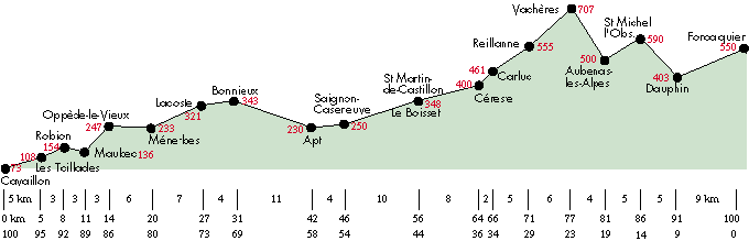
[ Cavaillon | Robion | Oppède | Ménerbes | Lacoste | Bonnieux | Apt | Céreste | Reillanne | Forcalquier ]
A cycling path between Cavaillon, Apt and Forcalquier crosses the Park Naturel Régional du Luberon. The path follows valleys along the northern edge of the Luberon Mountains, without steep climbs. The elevation difference of 477 m between Apt and Vachères is over a distance of 35 km.
The entire route has been selected for the beauty of the countryside and villages. Some parts follow roads, so normal cycling safety must be observed. Parts of the path follow the old railway line, crossing through some beautiful fields and woods. Between Bonnieux and Apt, the cycling path follows a small road that crosses the 2000-year-old Pont Julien.
Information
You can get more information, including the brochure "Le Luberon en Vélo" from the Offices de Tourisme of the Luberon towns and villages. Those in Apt, Bonnieux, Cavaillon and Forcalquier are open all year. Offices in Reillanne (Tel: (33) 492 75 10 02) and Dauphin (Tel: (33) 492 79 51 98) are open in July and August.
Cycle Rental-Repair
Cycle rental and repair shops are listed on Cycling-Shops - 84 for Apt, Cavaillon and Ménerbe, and on Cycling-Shops - 04 for Forcalquier.
Transportation
Bus service information between Cavaillon and Forcalquier is given on the Luberon page.