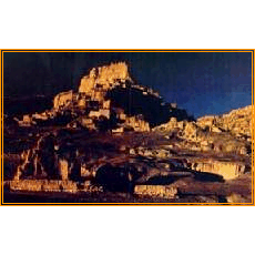
NAGRI
ííííThis prefecture is situated in the west, the middle part of the Chantang in Tibet, covering its area of thirty-four square km. It is 600 km long from the east to the west and 550 km from the south to the north. There are 7 counties in this region with the population of 6.9 hundred thousand, among which 85.2% are farmers and herders. It is the place with the smallest population density of 0.23 in each square km. It also has the name of í░the peak of mountainsí▒ í░the source of riversí▒ í░the top of the roof of the worldí▒.
It has the border line lasts 1116 km to India, Nepal and Kashimir to the south, connecting with Xinjiang to the west, and Nagchu to its north est.
This region is just situated in the meeting place of Himalaya, Gangdisi and Kalakunlun mount range with the elevation of 4,500 meters.
There are about 80 rivers and 60 lakes and the rivers lasts over 9,500 km, the water energy reserves reaches two hundred thousand kilowatt. The four rivers (Shichuan river, Xiangchuan river, Machuan river and Kongque river )from Gangdidi and Himalaya goes to the different directions to India and Nepal, and finally flows into the Indian ocean and Arab ocean.
There are also plenty of geothermal energy resources as Yaluzangpo zone, Kekesili zone, Nianqing Tangla zone.
The main industries in this region are agriculture, mining industry, animal husbandry with eighteen million, six hundred thousand hectare utilized pastureland. Over 30 mineral resources are proven such as Sault, boron, aluminium, chromium, silver, gold and mirabilite.
The windy times can lasts 149 days a year with 8 degrees of the wind-force. The temperature is about 0oC and the wind speed reaches 3.2meters/sec.
 | |
| |


|
|