DESTINATION MARSHALL ISLANDS
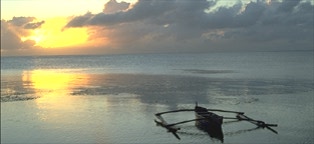
Comprising over a thousand flat coral islands of white sand beaches and turquoise lagoons, the Marshall Islands beckon visitors with all the promise of a tropical paradise. There's pristine diving and lush tropical greenery, and the Marshallese people retain many of their precolonial crafts and traditions, especially on the outer islands. You can still watch outrigger canoes zipping around the lagoons, though these days you're as likely as not to find a VCR in that little grass shack and Coke replacing coconut milk as many islanders' drink of choice.
The flipside to the paradise picture is that many of the Marshallese still struggle with the after-effects of the 20th century's nastiest technology. Several of the islands - the Bikini Atoll in particular - served as testing sites for atomic bombs through the 1960s, and many of their inhabitants have suffered from radioactive poisoning, while their home islands remain too contaminated to be resettled. And yet, despite these hardships, you'll find the Marshallese exceptionally welcoming and their culture and identity alive and well.
 Map of the Marshall Islands (11K) Map of the Marshall Islands (11K)
 Facts at a Glance Facts at a Glance
Full country name: Republic of the Marshall Islands
Area: 70 sq mi (180 sq km)
Population: 60,650
Capital city: Majuro (pop 27,000)
People: Micronesian
Languages: English (official), Malayo-Polynesian family, Japanese
Religion: Christian (predominantly Protestant)
Government: Constitutional government in free association with the US
President: Imata Kabua
 Environment Environment
If you could sweep the Marshalls' 1200-plus islands and atolls into a single land mass, it'd blanket an area about the size of Washington, DC, or the Caribbean island of Aruba. The islands are grouped into two main chains, Ratak (Sunrise) in the east and Ralik (Sunset) in the west; both run north-south and together spread out across some 750,000 sq miles (1,942,500 sq km) of the central Pacific.
The group lies some 2500 miles (4100km) southeast of Japan, 2500 miles (4100km) southwest of Hawaii and 1900 miles (3000km) northeast of Papua New Guinea. Its nearest neighbors are the other Micronesian states of Pohnpei and Kosrae, 650 miles (1000km) and 400 miles (650km) to the south, respectively, and Guam and the Northern Marianas, about 1500 miles (2500km) to the west.
The Marshalls consist of low coral limestone and sand islands and islets, the vast majority of which form scattered atolls. Only five are single islands. The islands are particularly narrow, with the widest, Wotje, less than a mile across. They have little fertile topsoil and are devoid of rivers. Their lowest points are their beaches and their highest - an unnamed hillock on Likiep, measuring 34ft (10m) - scarcely shows on the horizon. The country's average elevation is 7ft (2m) above sea level.
In Majuro, the average daily temperature is 81°F (27°C), with the chilliest moments coming during the rainy season, from September through November. The driest period is January through March; June to August are the hottest months. Water temperatures remain in the low 80s F (high 20s C) year round. Mild trade winds and tropical showers are the daily norm, full-blown tropical storms and typhoons are rare.
Hundreds of species of coral can be found in the Marshalls' atolls, as well as 250 species of reef fish and all five of the world's species of marine turtles. Whales, dolphins and porpoises also visit the islands' warm waters. Some 70 bird species have been identified, including over 30 species of seabirds. The Polynesian rat is the only mammal native to the islands, while of reptiles you can see a half dozen species of lizards and one species of blind snake. Coconut land crabs are common and prized for their meat.
The coconut palm tree is Micronesia's most important plant. Copra, the dried meat of the nut from which coconut oil is made, is among the country's leading exports. Other Marshallese flora includes breadfruit, pandanus, taro, arrowroot, yams, pumpkins, tapioca and bananas. As almost all the islands' lands are privately owned by families and clans, there are no national parks or reserves.
In the decades since the American government stopped its nuclear testing there, the US Department of Energy and California's Lawrence Livermore Laboratory have done extensive research on Bikini. Their reports tell us that the environment poses no danger to visitors.
 History History
The first Micronesian navigators arrived in the Marshall Islands sometime between 500 and 2000 BC. Little is known of their origin or culture.
The Marshalls were never united under a single leader, though one chief often controlled several atolls and at times an entire chain. Before the arrival of Europeans, the individual chiefs held absolute authority over their lands, and - living on such narrow stretches of land - their claims to their parcels were often hotly contested.
The 1494 Treaty of Tordesillas ceded ownership of all of Micronesia to Spain. The Marshalls, however, were off the main trade routes and consequently received little attention from early European explorers. In 1525, Alonso de Salazar of Spain became the first European to sight the islands, but Spain did nothing to colonize them. After another 200 years devoid of Europeans, the islands received a visit from English captain John Marshall (from whom they later took their name) in 1788. Russian explorer Otto von Kotzebue came through in the early 1800s and drew the first detailed maps of the islands.
Traders and whalers began to visit the islands en masse in the early 1800s, until encounters with the 'friendly' native Marshallese began to turn sour. Ship after ship putting into port at various atolls in the Marshalls quickly weighed anchor after the death of their captain or crew members. Violence was on the decline when the first Protestant missionaries arrived in 1857, setting up churches and schools and gradually undermining the traditional authority of the island chiefs.
Germany annexed the Marshalls in 1885 but didn't place government officials on the islands until 1906, leaving island affairs to a group of powerful German trading companies. Japan took over in 1914 and colonized the Marshalls extensively, developing and fortifying large bases on many of the islands.
The first Micronesian islands captured by the Americans in WWII were at Kwajalein Atoll in 1944. Majuro Atoll was taken next and quickly developed into a base for aircraft carriers. Within weeks some 30 other islands had fallen. After the war, the Americans immediately began to test atomic bombs on Bikini and Enewetok atolls. (Kwajalein was later established as a missile testing site.) Chief Juda of Bikini was convinced to move his people - for the 'benefit of mankind' - to Rongerik Atoll, on the understanding that they'd be able to return to their homeland after the tests were over. A few months later, the USA exploded the first of the 23 nuclear devices that were to be detonated at the atoll, 500ft (150m) over its lagoon.
The Bikinians nearly starved from inadequate food supplies on Rongerik, and two years later they were moved to Kwajalein Atoll and then to Kili Island. In the 1970s, they were told it was safe to return to Bikini, where they found two whole islands entirely blown away and most of the others treeless. Nevertheless, they stayed, and within a few years they were found to have dangerous levels of radiation in their bodies and were moved off the island again.
Today, scientists from California's Lawrence Livermore Laboratory are using Bikini as a case study in ways to clean up radiation. So far, they've had some success with using potassium fertilizer to block the uptake of cesium in plants, but there are still long-term problems with eating anything grown on the island. Ironically, as the Bikini cleanup continues, the Marshallese government is considering the atoll as a possible dump site for commercial radioactive waste material produced by Asian and North American power plants.
The Marshalls were hit hard by El Niño in 1997 and 1998, receiving almost no rainfall. Drought affected most of the country's population, particularly on Majuro and Ebeye.
 Economic Profile Economic Profile
GDP: US$94 million
GDP per head: US$1680
Annual growth: 1.5%
Inflation: 4%
Major industries: copra, fish, tourism, craft items, offshore banking (embryonic)
Major trading partners: US, Japan
 Culture Culture
Marshallese society has always been stratified, and despite increasing Westernization and the introduction of a moneyed economy, social status still comes as much from one's kinship as it does from one's own achievements. Chiefs continue to wield a great deal of authority over land ownership and usage.
Food cultivation on the islands has always been catch as catch can. Fish and seafood provide the bulk of the nonvegetable dishes, with tuna a staple of the catch. On land, breadfruit, coconut, arrowroot, yams, taro and pumpkins are the traditional mealtime mainstays. With the increasing Westernization of the Pacific, North American junk food has been increasingly dominating more traditional staples; on the rise too are the related health problems of obesity, diabetes, high blood-pressure and alcoholism.
In travels between the islands, early inhabitants learned to read the patterns of the waves and the positions of the stars, and they made stick charts to record and pass on their observations to less experienced navigators. By tying flat strips of wood together in imitation of the wave patterns and attaching cowry shells to the sticks to represent particular islands and atolls, the experienced navigator could memorize the patterns for when he was out at sea - the charts were not actually taken on the journeys. Although few modern Marshallese know how to read the charts, many still make them for their popularity as souvenirs.
Another craft once common in the Marshall Islands (but growing less so) is canoe building. The walap canoes of old could reach a length of 100ft (30m) and carry up to 40 people, with supplies for open-sea voyages that could last more than a month. The smaller and faster tipnol was used mainly for fishing inside the lagoons, while the korkor, a small outrigger sometimes fitted with a sail, was also used within the lagoons.
Marshallese and English are both official languages of the islands and are commonly spoken throughout the country. Indicative of islanders' general amicability, their traditional greeting, Yokwe yuk, means 'Love to you.'
 Events Events
Majuro plays host to a number of fishing tournaments each year, with the largest held on the weekend before the fourth Thursday in November and on the weekend closest to 4 July. Many islanders, expats and a growing number of international sportfishing enthusiasts show up with baited hooks.
Public Holidays
1 January - New Year's Day
1 March - Nuclear Victims Day
1 May - Constitution Day
First Friday in July - Fisherman's Day
First Friday in September - Labor Day
Last Friday in September - Culture Day
17 November - President's Day
First Friday in December - Gospel Day
25 December - Christmas
 Facts for the Traveler Facts for the Traveler
Visas: US citizens and Micronesian residents do not need a visa; everyone else must pay US$25 upon arrival. All visitors must possess a valid passport and an onward ticket.
Health risks: Dengue fever, typhoid fever, jellyfish, poisonous fish, coral and sea snakes
Time: GMT/UTC plus 12 hours
Electricity: 110V, 60Hz
Weights & measures: Imperial (see the conversion table)
Tourism: 6000 visitors per year
 Money & Costs Money & Costs
Currency: United States dollar (US$)
Relative costs:
Budget meal: US$1-5
Moderate restaurant meal: US$5-15
Top-end restaurant meal: US$15 and upwards
Budget room: US$30-60
Moderate hotel: US$60-100
Top-end hotel: US$100 and upwards
By international standards, travel in the Marshalls is relatively cheap, though by those same standards you'll be getting what you pay for. Most accommodations tend toward the austere, and there's not a whole lot to splurge on, food-wise, even if you wanted to. Restaurants don't exist outside the major atolls, and official hostelries are almost as scarce. Business-class hotels (of which there are few) all run over US$100 per night; the one resort in the country has rates more than double that. Budget travelers should be able to get by on US$50 per day, but that doesn't leave much room for things like scuba diving and island hopping. You'll have more fun if you plan on spending closer to US$100 daily.
There are banks in all the major tourist areas, and credit cards are becoming increasingly more widely accepted. Neither tipping nor bargaining is customary in the Marshall Islands, though the barter system is sometimes beneficial when looking for a place to stay or eat or a ride to a particular destination.
 When to Go When to Go
Rains are common in the Marshalls from March through April and more so from October through November, but these rarely come down hard enough to be called cyclones. Diving is at its best from May through October, when the water is calmest, though water temperatures are bathlike all year round.
 Attractions Attractions
Majuro Atoll
Most visitors to the Marshalls get only as far as Majuro Atoll, the nation's political and economic center and home to nearly half its populace. The atoll has 57 small islets, the largest of which are connected by a single 35 mile (55km) stretch of paved road, making Majuro appear to be one long, narrow island. Robert Louis Stevenson called the atoll the 'Pearl of the Pacific' when he visited in 1889, but it's a far less pristine Majuro that one sees today.
Majuro is the most Westernized of the Marshall Islands, but there's still a lot that can be learned about life in the islands from a visit. You can grasp what it's like to live on a ribbon of land so narrow that as often as not you can see the ocean on both sides. By visiting Laura Village, at the westernmost end of the mainland, you can find a rural lifestyle somewhat similar to that of the outer islands. While there, make use of the islands' best beach and Majuro Peace Park, a memorial built by the Japanese and dedicated to those who died in the East Pacific during WWII.
Three of Majuro's islands - Delap, Uliga and Darrit (Rita) - combine to form the D-U-D Municipality, the nation's capital and the most populous spot in the country. It's certainly no tropical paradise, but there are a few sights worth seeing. The Alele Museum is small, but its quality exhibits include displays of early Marshallese culture, stick charts, model canoes and shell tools. There's also a copra processing plant and the shockingly modernistic capitol building to visit.
Kwajalein Atoll
Nowhere in Micronesia is the US military presence so ominous as on Kwajalein Atoll, a missile testing range operated by the US Department of Defense. The world's largest coral atoll, Kwajalein includes 97 islands with a total land mass of just 6.5 sq miles (17 sq km) that surround an immense 1100 sq mile (2850 sq km) lagoon. The lagoon, sometimes called 'the world's largest catcher's mitt,' is the target and splashdown point for intercontinental ballistic missiles (ICBMs) fired from Vandenburg Air Force Base in California, 4200 miles (6700km) away. The tests generally occur at night, often lighting up the sky with a brilliant display of explosions, burning debris and sonic booms.
About 3000 American civilian contract workers and their families live on Kwajalein Island, a kind of all expenses paid summer camp for the workers. The whole subsidized suburbia of an island is, however, off limits to unofficial visitors except as a transit point to neighboring Ebeye Island. Ebeye, to the contrary, is home to about 1500 Marshallese laborers who work on Kwajalein but aren't allowed to live, shop or play there. The workers are shuttled by boat between their meager homes and their affluent work sites, where they can glimpse the good life all day long, so long as they don't touch. Needless to say, neither island is a big tourist draw, though their popularity with WWII wreck divers is increasing.
Arno Atoll
Arno is the closest atoll to Majuro, just 9 miles (15km) away. It has 133 islands, two airstrips and nearly 1700 people. The Longar area is famous for its 'love school,' where young women were once taught how to perfect their sexual techniques.
The waters off Longar Point are known for superb deep-sea fishing; marlin, yellowfin tuna, mahi-mahi and sailfish abound. About 10,000lbs (4500kg) of tuna and reef fish caught nearby are sold on Majuro each month, thanks in part to a Japanese-funded upgrade of the islands' fishing industry.
Wotje Atoll
Wotje, the main island of Wotje Atoll, is peppered from one end to the other with WWII remains. Huge Japanese-built structures loom out of the jungle, some bombed out, others still habitable. Right in the center of the village is a large Japanese gun that can still be moved on its pivot. The lagoon is also full of wreckage, including a few ships of interest to wreck divers.
The lagoon beaches of Wotje Island are beautiful and relatively clean. Those of the nearby smaller islands are even better, as they're mostly deserted, and at low tide you can walk right over to them. Known as the 'Marshallese garden center,' Wotje's abundant produce is due to topsoil shipped over from Japan.
Mejit Island
Mejit is a single coral island, less than one square mile in area, with a population of about 450 people. It's a beautiful island of lush taro patches and an abundance of coconut, breadfruit and pandanus trees. Since Mejit doesn't have a protective lagoon, fishing and the unloading of boats can be perilous, especially in November and December when the winds kick up. Mejit has a small freshwater lake, a rarity in the Marshalls, that makes for a lovely if algae-ful swim.
California Beach on the northwest side of the island is tops for swimming and snorkeling, and the waters around the island are prime for fishing. Best of all, unlike the other Marshalls, Mejit has no poisonous fish. The island is also known for its pandanus-leaf mats, woven by the Mejit women, and for the quality of its schools. Nearly everyone on Mejit speaks English.
Off the Beaten Track
Mili Atoll
Mili can be a good choice for travelers who want to visit one of the outer atolls, as it has friendly people and beautiful beaches and it's not too expensive to reach. After Kwajalein, Mili has the most land area of the Marshallese atolls, with a population of just over 850.
In 1937, famed US aviator Amelia Earhart disappeared in this part of the Pacific in the midst of a flight around the world. Although the mystery surrounding her disappearance remains, she was reportedly seen on Mili under Japanese custody long after her flight went missing.
As a major WWII Japanese base, Mili has many abandoned weapons, war planes and bombed-out buildings still scattered around. The atoll's oceanside beaches are great for shell collecting, while the lagoon's white-sand shores are perfect for lazy days of sunning and swimming. The surrounding waters have pristine diving.
Maloelap Atoll
Maloelap's Taroa (Tarawa) Island was the main Japanese airbase in the eastern Marshalls during WWII, and most visitors today come to see its rusting war relics. There are numerous twisted wrecks of Zeros and Betty bombers, plus pillboxes, an airfield, anti-aircraft guns and a Howitzer on wheels. The majority of the relics are buried now under a thick canopy of jungle foliage, but a few islanders are willing to guide visitors to the sites, so ask around if you're interested.
Off Taroa's lagoon beach, the Japanese freighter Toroshima Maru lies half submerged in the spot where it was hit by US bombers. It's been pretty well stripped, save for its periscopes, mast and a few live depth charges. If you swim around it, keep an eye out for the grouper (a type of sea bass) that's said to be as large as a human. Oh, and watch out for sharks, too.
Aur Atoll
About 75 miles (120km) north of Majuro, Aur Atoll is home to some 450 people who are equally divided between Tobal and Aur islands. The other islands in the atoll are mostly uninhabited, though they're used for copra cultivation. The atoll is fairly traditional, a good place to see men and women doing the same sort of thing they've done for ages. The locals specialize in making model canoes and large wall hangings.
Aur's lovely lagoon provides excellent snorkeling space. There's a good variety of tropical fish and coral, and it's not uncommon to see turtles and small sharks.
 Activities Activities
The Marshall Islands sit amid some of the world's most spectacular underwater scenery, and the traveler who never looks below the water's surface is missing out on some incredible sights. The water temperature is in the low 80s F (high 20s C) year round, so wetsuits aren't a necessity (some people wear them for coral-scrape protection, but they shouldn't swim that close to the coral anyway).
For natural attractions, Mili Atoll's waters boast some of the most pristine diving conditions in the country. Another popular site is Calalin Channel, which for all the right reasons has been dubbed 'Shark Alley.' Bikini and Jaluit atolls have some of the best WWII-era wreck diving found anywhere, with scores of warplanes, submarines and battleships to explore. Other good wreck dives are found near Kwajalein. Aur and Ailinglaplap atolls have excellent snorkeling, with a wide variety of tropical fish and corals, plus the odd sea turtle and shark.
Virtually all of the Marshalls have beautiful white-sand beaches, perfect for lounging in the sun even where the waters aren't the safest nor the most sanitary. Some of the best swimming spots are found at Ailinglaplap, Mili Island and Laura Beach at Majuro.
The islands' prime sportfishing catches include marlin, sailfish, yellowfin tuna, skipjack tuna, mahi-mahi and wahoo. Arno Atoll is famous for its abundant catches, as is Mejit, which also has octopus and lobster.
Birdwatchers will want to visit Bikar and Taongi (Bokaak) atolls, as they've both been tagged as potential national preservation areas. The latter was cited as being 'possibly the only example of a completely natural, unaltered, semiarid atoll ecosystem remaining in the world today.' Bikar has an especially large population of green sea turtles.
While in Majuro, you can also play tennis or go bowling, should the mood strike.
 Getting There & Away Getting There & Away
Majuro International Airport and Kwajalein Airport are served by Continental Micronesia, which links the islands to all of Micronesia's major district centers and Honolulu, and Air Marshall Islands, which flies some of the same routes and also to Fiji, Tuvalu and Kiribati. Travelers leaving the Marshalls must pay a US$15 departure tax.
Although there are inter-island boats within Micronesia, it's rare to find any sort of passenger vessel going to the Marshalls from countries outside the region, save the occasional private yacht.
 Getting Around Getting Around
Airstrips on many atolls are served by Air Marshall Islands puddlejumpers. Majuro and Kwajalein are the centers; a flight between the two takes around 50 minutes.
Majuro has a fine, incredibly cheap shared taxi system that's very easy to use - just stand at the side of the road and wave when they come by. There are also 15-passenger minivan taxis that generally stick to the island's main road. Either way, they're frequent and affordable.
Car rental is possible on Majuro at reasonable rates. Visitors are allowed to drive in Majuro for 30 days with their home country's driver's license. Gas is twice as expensive as in the US, half as much as in Europe. Driving is on the right.
Hotels can arrange boat rentals for you, but it's cheaper to cut out the middleman by making arrangements yourself - ask around the docks.
 Recommended Reading Recommended Reading
- Spoken Marshallese by Byron W Bender offers an intensive language lesson complete with grammatical notes and a glossary. A good companion to the text is the author's Marshallese-English Dictionary, co-written by Takaji Abo, Alfred Capelle and Tony DeBrum.
- The Reverend Francis X Hezel has published prodigiously on the country and the region. For starters, look for his Strangers in Their Own Land: A Century of Colonial Rule in the Caroline and Marshall Islands.
- Man This Reef by Gerald Knight is a collection of the translated tales and legends of an elderly Marshallese storyteller as told to the former curator of the Alele Museum in Majuro.
- For a broader look at Pacific Islander culture, pick up William H Alkire's An Introduction to the Peoples and Cultures of Micronesia, Gene Ashby's Micronesian Customs and Beliefs or Anne Nakono's Broken Canoe: Conversations and Observations in Micronesia.
- Jonathan M Wiesgall, the lawyer for the Bikini Islanders, dishes the inside dirt on cover-ups surrounding the atomic bomb tests in Operation Crossroads: The Atomic Tests at Bikini Atoll.
- Cineastes interested in the fallout from the Bikini bombings won't want to miss the Corporation for Public Broadcasting's Radio Bikini, ABC TV's Bikini: Forbidden Paradise and Dennis O'Rourke's Half Life.
- Divers should check out Dan E Bailey's WWII Wrecks of Kwajalein and Truk Lagoons, a coffee table book on the various wrecks found in those waters.
 Lonely Planet Guides Lonely Planet Guides
 Travelers' Reports Travelers' Reports
 On-line Info On-line Info
-
|