 Facts at a Glance Facts at a Glance
Full country name: Republic of Guatemala
Area: 109,000 sq km (42,500 sq mi)
Population: 11 million (growth rate 2.5%)
Capital city: Guatemala City (pop 2 million)
People: 56% Spanish descent, 44% Mayan descent
Language: Spanish, Garífuna and 21 Maya languages
Religion: Roman Catholic, Pentecostal, Mayan-Catholic fusion
Government: Democratic
President: Álvaro Enrique Arzú Irigoyen
Guatemala is Central America's westernmost country, bordering Mexico to the north and northwest, Belize to the north-east and Honduras and El Salvador to the east. Guatemala's volatile topography is a mountainous and forested jumble of volcanoes and jungle. The western highlands are home to over 30 volcanoes, which reach heights of up to 3800m (12,464ft) and cast a red glow at night. The area experiences frequent earthquake activity. The intensively cultivated Pacific coastline is a vast expanse of mostly black-sand beaches, and the tiny Caribbean coastline also lacks beaches but is culturally rich. The vast jungle lowland of El Petén fills the interior, characterized by a mix of banana plantations and soils rich in dinosaur bones.
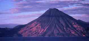
 Lago de Atitlán & Volcán Tolimán (9K) Lago de Atitlán & Volcán Tolimán (9K)
Guatemala's national bird is the quetzal - a gorgeous creature which is almost extinct, due to deforestation and poachers. Jaguar, ocelot, puma, jaguarundi and margay - and their assorted diet of deer, peccary and tapir - survive, though are seldom seen.
The Pacific coast is tropically sweltering, with temperatures often hovering around 38°C (100°F). The seemingly constant high humidity abates a little in the dry season. The highlands are freezing at night, dank and chill during the rainy season and warm and delightful in the dry season (October to May). El Petén's climate varies only from hot and humid to hot and dry.
The fishing and farming villages which emerged on Guatemala's Pacific coast as early as 2000 BC were the forerunners of the great Maya civilization which dominated Central America for centuries, leaving its enigmatic legacy of hilltop ruins. By 250 AD, the Early Classic Period, great temple cities were beginning to be built in the Guatemalan highlands, but by the Late Classic Period (600 to 900 AD) the center of power had moved to the El Petén lowlands. Following the mysterious collapse of the Maya civilization, the Itzaes also settled in El Petén, particularly around the present-day site of Flores.
Ceibal ruins, El Petén (15K)
When Pedro de Alvarado came to conquer Guatemala for the king of Spain in 1523, he found the faded remnants of the Maya civilization and an assortment of warring tribes. The remaining highland kingdoms of the Quiché and Cakchiquel Maya were soon crushed by Alvarado's armies, their lands carved up into large estates and their people ruthlessly exploited by the new landowners. The subsequent arrivals of Dominican, Franciscan and Augustinian friars could not halt this exploitation, and their religious imperialism caused valuable traces of Mayan culture to be destroyed.
Independence from Spain came in 1821, bringing new prosperity to those of Spanish blood (creoles) and even worse conditions for those of Mayan descent. The Spanish Crown's few liberal safeguards were now abandoned, and huge tracts of Mayan land were stolen for the cultivation of tobacco and sugar cane, and the Maya were further enslaved to work that land. The country's politics since independence have been colored by continued rivalry between the forces of the left and right - neither of which have ever made it a priority to improve the position of the Maya.
 The yellow fruit that saw red The yellow fruit that saw red
Few exceptional leaders have graced Guatemala's political podium. Alternating waves of dictators and economics-driven Liberals were briefly brightened by Juan José Arévalo, who established the nation's social security and health systems and a government bureau to look after Mayan concerns. In power from 1945 to 1951, Arévalo's liberal regime experienced 25 coup attempts by conservative military forces. Arévalo was followed by Colonel Jacobo Arbenz Guzmán, who continued to implement liberal policies and instituted an agrarian reform law to break up the large estates and foster highly productive, individually owned small farms. The expropriation of lands controlled by foreign companies, a move supported by the country's Communist Party, was the signal for the CIA to step in. With their help a successful military coup was organized in 1954, Arbenz Guzmán fled to Cuba and the land reform never eventuated.
A succession of military presidents followed, and as both protest and repression became more violent, civil war broke out. Booming industrialization in the 1960s and '70s helped the rich get richer, while the cities became increasingly squalid as the rural dispossessed fled the countryside to find urban employment. The military's violent suppression of antigovernment elements (which meant the majority of landless peasants) finally led the USA to cut off military assistance, leading in turn to the 1985 election of the civilian Christian Democrat Marco Vinicio Cerezo Arévalo.
Arévalo's five years of inconclusive government were followed by Jorge Serrano Elías, who won the presidency for the conservative Solidarity Action Movement. His attempts to end the decades-long civil war failed, and as his popularity declined he came to rely increasingly on military support. On 25 May 1993, following a series of public protests, Serrano carried out an auto-coup. Lacking popular support, Serrano fled the country, and an outspoken critic of the army, Ramiro de León Carpio, was elected by Congress. Carpio's law-and-order mantle has recently been taken up by new president, Alvaro Arzú, who is attempting to heal his feuding and crime-ridden country with a neo-liberal technocratic salve. In December 1996, the government signed a series of peace accords with leftist guerrillas and the army agreed to reduce its role in domestic security matters. The greatest challenge to a lasting peace stems from great inequities in the basic social and economic power structure of Guatemalan society.
GDP: US$9.6 billion
GDP per head: US$980
Inflation: 9%
Major industries: Coffee, sugar, bananas, tobacco
Major trading partners: USA, El Salvador, Costa Rica, Honduras, Mexico
 Culture Culture
Guatemala's many Mayan ruins and colonial buildings are its most impressive architectural attributes. One of the most intriguing cultural aspects is the infinite and exotic variety of the handmade, traditional clothing of Guatemala's Maya population. The design of the women's colorfully embroidered tunics, capes and skirts dates back to precolonial days. Certain details of garment and design identify the wearer's group and village, and can also have multiple religious or magical meanings. Music and traditional dance also feature in many Mayan religious festivals.
Basilica at Esquipulas (17K)
Spanish is the most commonly spoken language in Guatemala, and Roman Catholicism is the principal religion. Evangelical and Pentecostal Christian denominations have gained wide followings, while the Maya have preserved aspects of their traditional religions, often blended with Catholicism.
Guatemalan cuisine can't compete with that of Mexico, although standard Mexican fare such as tortillas and tacos can be found. Mostly you'll encounter tough grilled or fried meat, meat and more meat. Beans and rice are often the cheapest and best alternative, and the country has a surprising number of Chinese restaurants. Coffee is available everywhere - sometimes spectacularly good, but often ridiculously weak and sugary. Beer is prevalent, in light and dark versions, and rum and Quetzalteca are the nation's favored rocket fuels.
Semana Santa (Holy Week - the week before Easter) is Guatemala's biggest festival, featuring processions and celebrations throughout the country - Antigua's fiesta is said to be the best. Rabin Ajau, held in Cobán, is a traditional Kekchi Indian festival which runs from July 21-26. Independence Day is celebrated nationwide in September. November features All Saints' Day, and Chichicastenango commemorates Santo Tomás from December 13-21.
Visas: Visa regulations changed in 1996 and citizens of most countries no longer need either a visa or a tourist card. Depending on the country you come from, stays are limited to 30 or 90 days. Citizens of some countries still need either a visa or a tourist card, so check with the closest Guatemalan embassy for up-to-date information.
Health risks: Cholera, dengue fever, malaria
Time: GMT/UTC minus 6 hours
Electricity: 110V, 60Hz
Weights & measures: Metric (see the conversion table.)
Currency: quetzal
Relative costs:
- Budget room: US$6-10
- Moderate hotel: US$10-20
- Top-end hotel: US$20 and upwards
- Budget meal: US$3-4
- Moderate restaurant meal: US$5-7
- Top-end restaurant meal: US$7 and upwards
Guatemala is one of the cheapest destinations in Central America. You can pick up a one-plate meal for less than US$2, or stuff yourself on almost-free fruit and snacks from elaborate markets. Camping is incredibly cheap, and bus trips cost around US$1 an hour. Even if you splash out on a few comforts, you should be able to get a room with a bathroom, plus two or three meals, for US$25 a day.
It's a waste of time trying to change anything other than US dollars - even currencies from neighboring countries will probably prove impossible to exchange. If you do have a different currency, try the casas de cambio at Flores or Guatemala City airports. Changing money on the black market won't bring you a much better rate than at the bank, but you may have no choice if you're quetzal-less at border crossing points. ATMS are springing up around Guatemala City, and most banks will give you an advance on your Visa card over the counter.
Restaurants expect a tip of around 10%, on top of the 10% value-added tax. On top of this VAT, hotels charge 10% tourist tax. Most hotels and shops have fixed prices, but you'll be expected to bargain at markets - remember to keep your sense of humor and perspective.
The dry season, from late-December to mid-April, is the most pleasant time, climatically, to be in Guatemala. Along with summer holidays, however, this is also the busiest time. Although the rain may restrict some activities during the wet season, it's still worthwhile planning your trip for this time of year, particularly as you'll be more likely to pick up accommodation bargains. If you're planning to be in the area around Easter, try to be in Guatemala for Semana Santa (Holy Week), the highlight of the country's festival calendar.
 Warning Warning
A relatively high level of violent crimes are committed against foreigners in Guatemala, so travelers should be alert to potentially dangerous situations. Incidents of bus and car-jackings are quite common, and Guatemala's larger cities can be dangerous after dark. Intercity travel after sunset should be avoided. Kidnappings, rapes and assaults do occur during daylight hours and in some cases affect entire groups of travelers.
Guatemala City
Guatemala City is the largest urban agglomeration in Central America. It sprawls across a range of flattened, ravine-scored mountains, covering an entire mountain plain and tumbling into the surrounding valleys. With its suicidal bus drivers and throngs of awesomely armed uniformed personages, the city's Latin character is over the top to the point of cliché. Like all Guatemalan towns, a strict grid system has been imposed on the city's layout: avenidas run north-south; calles run east-west. The huge city has been divided into 15 zones, each with its own version of this grid system.
Few colonial buildings grace the city, and it is visited more for its role as the nation's administrative and transport hub than as a must-see tourist site. In Zona 1, Plaza Mayor is a classic example of the standard Spanish colonial town-planning scheme, and is the city's ceremonial center and retail district. It's best visited on a Sunday, when it's thronged with thousands of locals who come to stroll, eat ice cream, smooch on a bench, listen to boom-box salsa music and ignore the hundreds of trinket vendors. The square is lined by the imposing but earthquake-battered Palacio Nacional and the twin-towered Catedral Metropolitana. An earthquake destroyed the original market building adjacent to the square in 1976, and today the hugely chaotic Mercado Central specializes in tourist-oriented crafts.
Street scene, Guatemala City (18K)
Palacio Nacional, Guatemala City (17K)
North of Zona 1 is the shady and restful Parque Minerva, featuring a quirky relief map of the country. Several important museums can be found in Zona 10, including the Museo Popol Vuh, which is a superb private collection of Mayan and Spanish colonial art, and the Museo Ixchel, which displays the rich traditional arts and costumes of Guatemala's highland towns. Zona 13 houses the Museo Nacional de Arqueología y Etnologí, with its prized collection of Mayan art, and the Museo Nacional de Arte Moderno, which has a superb collection of 20th-century Guatemalan art. Several km west of the center lie the extensive ruins of Kaminalijuyú, an important Early Classic Maya site. Unfortunately, the ruins have been largely covered by urban expansion.
Most of the city's cheap and middle-range hotels are in Zona 1, while posh hotels are clustered in Zona 10. Zona Viva is the place to go to eat expensively and dance the night away.
Antigua was the nation's capital from 1543 until the devastating earthquake of 1773, when the capital was moved 45km (28mi) to the east to the present site of Guatemala City. Antigua is among the oldest and most beautiful cities in the Americas. Set amid three magnificent volcanoes - Agua, Fuego and Acatenango - its superb yet sturdy colonial buildings have weathered 16 earthquakes and numerous floods and fires. Antigua is especially beautiful during Semana Santa, when the streets are carpeted with elaborate decorations of colored sawdust and flower petals. The city's churches have lost much of their Baroque splendor, the post-earthquake repair and restoration leaving them denuded of embellishment and elegance. However, many remain impressive, in particular La Merced, the Iglesia de San Francisco and the Convento de las Capucinas (now a museum). Casa K'ojom is a fascinating museum of Mayan music and ceremonies and related artifacts, and a visit to the local cemetery also provides an insight into ancient Mayan beliefs. On Sundays, visitors and locals alike gather to assess the goods for sale at the bustling market held in Parque Central.
Market in the plaza, Antigua Guatemala (16K)
At 2030m (6658ft), the magical and misty highlands town of Chichi is surrounded by valleys and overshadowed by looming mountains. Though isolated, it's always been an important market town. The Sunday market is the one to catch, as the cofradías (religious brotherhoods) often hold processions on that day. The locals have combined traditional Mayan religious rites with Catholicism; the best places to witness these old rites are around the church of Santo Tomás and the shrine of Pascual Abaj, which honors the Mayan earth god. Incense, food and drink are offered to ancestors and to ensure the continued fertility of the earth. The town's Museo Regional contains ancient clay pots and figurines, flint and obsidian spearheads, maize grindstones and an impressive jade collection.
Quetzaltenango
The commercial center of southwestern Guatemala, Quetzaltenango is an excellent base for excursions to the many nearby villages, noted for their handicrafts and hot springs. The city prospered during the 19th century as a coffee-brokering and storage center, until an earthquake and volcanic eruption ended the boom. The town's major sights are the central square and the buildings which surround it, a couple of basic though useful markets and the ubiquitous Parque Minerva - many such monuments honoring the classical goddess of education in the hope of inspiring Guatemalan youth to new heights of learning were built during the presidency of Manuel Estrada Cabrera (1898-1920). The beautiful volcanic countryside surrounding Quetzaltenango features natural steam baths at Los Vahos and Fuentes Georginas. Also in the vicinity is the picture-postcard village of Zunil, the market town of San Francisco El Alto and the handicrafts village of Momostenango.
Flores
The capital of the jungle-covered northeastern department of El Petén, Flores is built on an island on Lago de Petén Itzá, and is connected by a 500m (1640ft) causeway to the service town of Santa Elena on the lakeshore. Flores is a dignified capital, with its church and government building arranged around the main plaza, which crests the hill in the center of the island. The city was founded by the Itzaes, and at the time of conquest was perhaps the last still-functioning Mayan ceremonial center in the country. The pyramids, temples and idols were crushed under the foundations of the Spanish city, and the dispersal of the Mayan citizens into the jungle gave rise to the myth of a `lost' Mayan city. Modern sights include boat rides stopping at various lagoon settlements and a visit to the limestone caves of Actun-Can.
Panajachel
Don't be deterred by this town's nickname of Gringotenango ('place of the foreigners'), nor by the town's lack of colonial architecture or colorful market. The attraction here is the absolutely gorgeous caldera lake (a water-filled collapsed volcanic cone). Since the hippy days of the 1960s, laid-back travelers have flocked here to swim in Lago de Atitlán and generally chill out. Volcanoes surround the lake, and the town is the starting point for excursions to the smaller, more traditional indigenous villages on the western and southern shores of the lake. The most popular day-trip destination is Santiago Atitlán, with its colorfully dressed locals and a unique, cigar-smoking resident deity called Maximón. The market town of Sololá has been attracting traders for centuries, and the town's main plaza continues to throb with activity on market days. Village life can be sampled at Santa Catarina Palopá, while lakeside San Pedro La Laguna is perhaps more attractive because it is less visited.
'Mayan relics' shop, Panajachel (18K)
Sololá market (21K)
Situated on Guatemala's Pacific slope, this is an important site for anyone interested in Mayan art and culture. The sugar cane fields are dotted with great stone heads and scenes carved in relief. The artifacts are the remnants of the Pipils, a non-Mayan Indian culture linked to that of the Nahuatl-speaking peoples of central Mexico. There are three main archaeological sites in the surrounding sugar cane fincas (ranches or plantations). Bilbao consists of several ceremonial sites containing stone sculptures, many of which are hidden among the cane. Hilltop Finca El Baúl has the additional fascination of being a still-active place of worship, while Finca Las Ilusiones contains hundreds of objects which have been collected from the fields over the centuries.
Bas-relief, Santa Lucía Cotzumalguapa (21K)
The monumental Mayan ceremonial center at Tikal lies northwest of Flores in the department of El Petén. Its jungle location makes it a unique site. Towering pyramids rise above the jungle's green canopy, while down below howler monkeys swing nosily through the branches of ancient trees, colorful parrots squawk and dart and tree frogs fill in the auditory gaps. The steep-sided temples rise to heights of over 44m (144ft), and although the undergrowth around them has been cleared, the dense rainforest canopy is not far away, making passage within the enigmatic site an unforgettable experience. The many ruins include plazas, an acropolis, pyramids, temples and a museum.
Great Plaza & North Acropolis, Tikal (16K)
The laid-back jungle hideaway of Lívingston is accessible from the Caribbean port of Puerto Barrios. Black Afro-Guatemalans called the Garifuna live on the island, descendants of Africans brought to the New World as slaves who escaped or were shipwrecked. Intermarriage with shipwrecked sailors of other races and the indigenous Maya has created a distinctive culture and language incorporating African, Mayan and European elements. Tiny Lívingston is an interesting anomaly, the way of life definitely more Belizean than Guatemalan, with coconut groves, gaily painted wooden buildings and a fishing economy. The town is the starting point for boat rides on the Río Queqüeche and Río Cocolí, which take you through tropical jungle scenery for a swim or a picnic, or out to the Cayos Sapodillas for snorkeling and fishing.
Apart from the many activities with a Mayan connection, Guatemala offers great hiking and climbing in the highlands and the volcanoes surrounding Lago de Atitlán and Antigua. Contact your embassy or consulate in Guatemala City for information on the current safety of particular areas before setting out. Keep an eye out for the national bird, the quetzal, when birdwatching around Tikal National Park or Lago de Atitlán. Spanish language courses are a popular feature of Antigua and Quetzaltenango.
Major international airlines fly into Guatemala City and Flores. Most flights to the country pass through the North American hub cities of Dallas/Fort Worth, Los Angeles or Mexico City. There is a US$10 departure tax.
To enter the north of the country by land means entering from Mexico by lengthy bus or train journeys. Buses from El Salvador travel directly to Guatemala City, while buses from Honduras stop at the border. Travel from Belize is along a very rough dirt road through mountainous jungle. You can also enter the country by sea, traveling from Punta Gorda in Belize to Puerto Barrios or Lívingston. There is also a boat from Lívingston to Omoa in Honduras.
Unfortunately, internal flights only operate between Guatemala City and Flores. Buses link most places cheaply and relatively painlessly, although roads in El Petén often turn into muddy mires or disappear altogether during the rainy season, and there are minibuses operating between some of the more popular tourist sites. Some of Guatemala's national parks are only accessible by boat.
 Recommended Reading Recommended Reading
- I, Rigoberta Menchu is the autobiography of Guatemala's Indian Nobel Peace Prize winner - a very personal and moving story of Mayan life and government repression.
- Time and the Highland Maya by Barbara Tedlock is an anthropological study of the Quiché Indians of Momostenango.
- Unfinished Conquest: The Guatemalan Tragedy by Victor Perera looks at the history of the Maya and their situation in modern Guatemala.
- The Central America Fact Book by Tom Barry & Deb Preusch examines the economic, political and military role of the USA in Central America.
- Birds of Guatemala by Hugh C Land is a field guide to - surprisingly enough - the birds of Guatemala.
- Clamor of Innocence: Central American Short Stories, edited by Barbara Paschke & David Volpendesta, contains 31 short stories by writers from the region.
 Lonely Planet Guides Lonely Planet Guides
 Travelers' Reports Travelers' Reports
|


 Environment
 History
 Economic Profile
 Events
 Facts for the Traveler
 Attractions
 Off the Beaten Track
 Activities
 Getting There & Away
 Getting Around
 On-line Info