 Facts at a Glance Facts at a Glance
Full country name:Republic of Namibia
Area: 824,290 sq km (321,473 sq mi)
Population: 1,660,000
Capital city: Windhoek
People: 85% black (Ovambo 45%), 7.4% white settlers (German and Afrikaan), 7.6% mixed
Language: Afrikaans, German, English, Ovambo, Bantu, Khoisan
Religion: 75% Lutheran, 10% Animist
Government: Democratic Republic
President Sam Nujoma
Namibia is on Africa's south-western coast, bordering South Africa in the south, Botswana in the east, and Angola in the north. The skinny eastern appendage, the Caprivi Strip, connects Namibia to Zambia and Zimbabwe. The country is largely arid, but encompasses broad geographical variations and is usually divided into four regions: the Namib Desert and Coastal Plains along the coast; the scrubby, eastward-sloping Central Plateau; the Kalahari sands along the Botswana and South African borders; and the dense bushveld (woodland) of the north-eastern Kavango and Caprivi regions. The northern border is flush with rivers that provide water to most of Namibia.
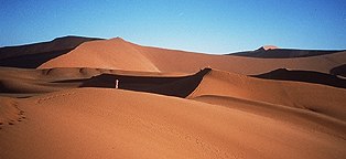
The Namib Desert, the world's oldest arid region, has been around for over 80 million years. It extends along Namibia's entire Atlantic coast. Namib landscapes range from the mountainous red dunes in the south to the centre's interior plains and flat-topped, steep-sided, isolated mountains called inselbergs. The desert is scored by a number of rivers that rise in the Central Plateau but seldom carry water. East of the desert the altitude increases and the dunes give way to gravel plains. In the north these plains are honeycombed with caves and rock shelters that once harboured early humans.
Namibia has some of Africa's most diverse natural habitats. Even in the desert you'll find elephant, giraffe and zebra; lions once came down to the sea, but have been pushed out of the dunes by poachers. Flocks of flamingo live in Etosha National Park in the north. The Cape Cross Seal Reserve on the central coast is home to 100,000 Cape fur seal.
Although it's predominantly a desert, Namibia enjoys regional climatic variations. The most arid climate is found in the central Namib, where summer daytime temperatures climb to over 40°C (105°F) but can fall to below freezing at night. Daytime temperatures in the mountainous and semi-arid Central Plateau (including Windhoek) are generally lower than in the rest of the country. Fog is common on the coast. December is the hottest month everywhere, when daily temperatures hit an average high of 30°C (86°F). There are two rainy seasons: the 'little rains' from October to December and the main rainy period from January to April. Low-lying areas in the eastern part of the country are generally much hotter than the Central Plateau and, except for Kavango and Caprivi in the north-east, receive little rain.
 History History
Southern Africa's earliest inhabitants were the San, nomadic people organised in extended family groups who could adapt to even the severest terrain. San communities later came under pressure from Khoi-Khoi groups. The Khoi-Khoi were a tribal people who raised stock rather than hunted, and who were among the first pottery makers in the archaeological record books. They came from the south, gradually displacing the San, and remained in control of Namibia until around 1500 AD. Descendants of the Khoi-Khoi and San people still live in the country, but few have retained their original lifestyles. Between 2300 and 2400 years ago, the first Bantus appeared on the plateaus of south-central Namibia. Their arrival marked the first tribal structures in southern African societies. Other tribes either retreated to the desert or the swamps of the Okavango Delta or were enslaved into Bantu society.
Because Namibia has one of the world's most barren and inhospitable coastlines, it was largely ignored by European explorers. The first European visitors were Portuguese mariners seeking a way to the Indies in the late 15th century, but they confined their activities in Namibia to erecting stone crosses at certain points along the coast as navigational guides. It wasn't until the last minute scramble for colonies towards the end of the 19th century that Namibia was annexed by Germany, except for the enclave of Walvis Bay, which was taken in 1878 by the British for the Cape Colony. In 1904, the Herero people, who were Bantu-speaking cattle herders, launched a rebellion, but it was brutally put down. Meanwhile, in the south, diamonds had been discovered east of Lüderitz by a South African labourer. In the blink of an eye, the German authorities branded the entire area between Lüderitz and the Orange River a sperrgebiet, or 'forbidden area'. German rule came to an end during WWI when German forces surrendered to a South African expeditionary army fighting for the Allies.
At the end of WWI, South Africa was given a mandate to rule the territory (then known as West South Africa) by the League of Nations. The mandate was renewed by the United Nations following WWII but the organisation refused to sanction the outright annexation of the country by South Africa. Undeterred, the South African government tightened its grip on the territory and, in 1949, granted parliamentary representation to the white population. The bulk of Namibia's viable farmland was parcelled into 6000 farms owned by white settlers, while black workers and their families were confined by law to 'reserves'.
Forced labour had been the lot of most Namibians since the German annexation, and was one of the main factors which led to mass demonstrations and the development of nationalism in the late 1950s. Around this time, a number of political parties were formed and strikes organised. By 1960 most of these parties had merged to form the South West Africa People's Organisation (SWAPO), which took the heated issue of South African occupation to the International Court of Justice.
The court's outcome was inconclusive but in 1966 the UN General Assembly voted to terminate South Africa's mandate and set up a Council for South West Africa to administer the territory. SWAPO adopted guerrilla tactics at the same time, but the organisation's failure to establish an internal government in Namibia made it easy for South Africa to assert control. South Africa refused to negotiate on a UN-supervised programme for Namibian independence unless an estimated 19,000 Cuban troops were removed from neighbouring Angola. In response, SWAPO intensified its guerrilla activities, severely restricting movement in the north of the country.
The Namibian population grew tired of the war and the economy suffered badly. By 1985, South Africa was also feeling the pinch and was distracted by internal problems of its own. A UN-sponsored deal ensured Cuban troops left Angola if South African troops exited Namibia. UN-monitored elections were held in November 1989 and SWAPO won a clear majority of the votes. A constitution was adopted in February 1990 and independence granted the following month under the presidency of SWAPO leader Sam Nujoma. Nujoma was re-elected in 1994 and embarked on a reconstruction programme for the country based on the retention of a mixed economy and partnership with the private sector. Nujoma tied Namibia's currency to the South African rand in March 1998.
 Economic Profile Economic Profile
GDP: US$6 billion
GDP per head: US$3700
Annual growth: 1.5%
Inflation: 8%
Major industries: Mining (diamonds and uranium), livestock, agriculture, fishing
Major trading partners: UK, South Africa, Spain, Japan
 Culture Culture
Namibia's population includes at least 11 major ethnic groups, ranging from hunter-gatherers to rural farmers and town dwellers, and the country still bears the influences of its German and Afrikaner colonisers. The 650,000-strong Ovambo make up the largest group and live mainly in the north. Other significant tribes include the Kavango, Herero, Himba, Damara, Nama and Basters. A tinier group, the San, once had their own land division system and in the early 19th century were responsible for one of the most extensive pre-colonial trade networks in the region.
Although the country is still developing a literary tradition, music, dance, and the visual and architectural arts have long been part of the local culture. Namibia's earliest musicians were the San, whose music emulated the sounds made by animals and was played to accompany dances and storytelling. The early Nama used drums, flutes and stringed instruments; and the later arriving Bantu people added marimbas, gourd rattles and animal horn trumpets. Missionaries established local religious choral groups. Township art, which develops sober themes in a colourful and generally lighthearted manner, first appeared in the townships of South Africa during the apartheid years. It has taken hold in Namibia and is rapidly developing into a popular art form; names to watch for include Tembo Masala and Joseph Madisia.
Each ethnic group within Namibia has its own pantry of preferred foods. The staple for the Ovambo people is mielie pap, a cornmeal porridge, or mahango (millet), also made into a porridge or soup. Both mielies and mahangos are typically eaten with fish, goat, lamb or beef stew. Pumpkins, peppers and onions also feature prominently. The desert-living Nama people have revered the spiky !nara melon for tens of thousands of years, and its yearly harvest is a significant event. Endemic to the desert, some say that the !nara made human existence possible in the Namib. The Herero subsist mainly from milk products such as curds and butter. The leftover European cuisine is mostly German, and big on boerewors, a huge 'farmers sausage'. Pastries, breads, cakes, fruit and cold cuts also derive from the Germans. Traditional brews include mataku (watermelon wine) and walende, a distilled-palm spirit that tastes like vodka.
A big event to watch for is Maherero Day, towards the end of August, when the Herero people gather in traditional dress at Okahandja (just north of Windhoek) for a memorial service to the chiefs killed in the Khoi-Khoi and German wars. In October there's a similar event for the Hereros in Omaruru (north-west of Windhoek) to honour their chief Zeraua. Independence Day on 21 March is celebrated with feasts and festivities all over Namibia. The Windhoek Carnival held over a week in late April is a big social event for city sophisticates, as is the Küste Karnival at Swakopmund in late August or early September, and the Windhoek Agricultural Show in late September. Oktoberfest, with all its beer swilling and sausage sizzling, is vigourously celebrated throughout the country in late October.
Visas: Most visitors to Namibia do not require a visa
Health risks: Bilharzia (in the east), malaria (in the north-east)
Time: GMT/UTC plus two hours
Electricity: 220V, 50Hz
Weights & measures: Metric (see conversion table)
 Money & Costs Money & Costs
Currency: Namibian dollar
Exchange rate: US$1 = N$4.9685
Relative costs:
- Budget room: US$15-25
- Moderate hotel: US$30-40
- Top-end hotel: $50 plus
- Budget meal: US$6-8
- Moderate restaurant meal: US$10-15
- Top-end restaurant meal: $25 plus
Namibia is a relatively inexpensive country to visit. Budget travellers need only spend about US$25 a day if they camp or stay in backpackers' hostels, self-cater and use public transportation. A mid-range budget of around US$60 a day secures inexpensive hotels and a couple of daily restaurant meals. Better hotels, habitual restaurant meals, guided tours and a rented 4WD requires at least US$100 a day.
Major foreign currencies and travellers' cheques can be exchanged in any bank. Rates for travellers' cheques are better than cash. When changing money, you can choose between Namibian dollars or South African rand; for changing leftover money after your trip, rand is better. Credit cards are widely accepted in shops, restaurants and hotels.
An 11% sales tax is applied to most purchases, including meals and accommodation, but it's not normally included in marked prices. Tipping is only expected in up-market restaurants, and only if a service charge hasn't already been added to the bill. Tipping is prohibited in national parks and reserves. Bargaining, particularly in rural markets, is a local way of life, especially for arts and crafts.
 When to Go When to Go
The dry winter season (May to October) is the most pleasant time to visit Namibia. It's best to avoid Namib and Etosha national parks in the extreme heat between December and March. Resort areas are busiest over both Namibian and South African school holidays, which usually take place from mid-December to mid-January, late-April to early June, and late-August to mid-September.
 Attractions Attractions
Windhoek
Namibia's Central Highlands are dominated by its small, Germanic capital, Windhoek. Set at the geographical heart of Namibia, it serves as the nerve centre of the country's business and commercial operations and boasts Namibia's international airport. Situated among low hills at an elevation of 1650m (5410ft), Windhoek enjoys a refreshing highland climate with considerable temperature variations and a lot of rain. The wetness results in lush gardens and spectacular flower beds. Windhoek has only 130,000 people, but Namibia's ethnic mix is reflected throughout the city's streets.
The city centre is characterised by a mix of German colonial structures and pastel-coloured modern buildings. Dominating the skyline is Christuskirche, the neo-Gothic and Art Nouveau-designed German Lutheran church. Other striking buildings include the parliament building, Tintenpalast; the whitewashed Alte Feste, an old fort that's now a museum; and the Cape Dutch-style railway station, which dates back to 1912.
Windhoek is great for meandering around on foot, and the hour-long Hofmeyer Walk takes in the nearby bushland of the Klein Windhoek Valley and provides a panoramic view of the city. In the centre of the Post Street pedestrian mall is a display of 33 meteorites from the Gibeon meteor shower, which deposited 21 tonnes (24 US tons) of extraterrestrial boulders on the area of Gibeon in southern Namibia in 1837.
One of the world's greatest wildlife-viewing venues, Etosha National Park is the Namibian destination for many travellers. The western part of the park is characterised by scrubby savannah but further east, the scrub gives way to mixed woodland. The lifeblood of Etosha is the Etosha Pan - an immense, flat, saline desert that only occasionally holds water. During winter months, perennial springs around its edges draw large concentrations of birds, elephants, giraffes, lions, zebras and a few cheetahs and leopards. The animals of Etosha also include such protected species as the black-faced impala and black rhino. After exceptionally rainy periods, the pan fills with up to a metre (3ft) of water and enormous numbers of flamingoes and pelicans arrive to feed and breed. You'll have the best chance of seeing the animals gather around the water holes between May and September.
Although Etosha may be visited on a day trip, it's impossible to see much of the park in fewer than three days. Most visitors opt for at least a couple of nights at one of three rest camps (Namutoni, Halali and Okaukuejo), which are spaced about 70km (43mi) apart and have excellent facilities. Etosha is over 500km (310mi) north-west of Windhoek. The town of Tsumeb has the nearest commercial airport. It's also possible to take a bus or train to Tsumeb from Windhoek, but thereafter, travellers headed for Etosha must join a tour or hire a car as there's no public transport into the park.
Lüderitz is a surreal colonial relic - a Bavarian village huddling on the barren, windswept coast of the Namib Desert, seemingly untouched by the 20th century. It's everything you'd expect of a small German town, from delicatessens and coffee shops to Lutheran churches. The coastline is home to penguins and seals; the desolate beaches support flocks of flamingo and ostrich. Lüderitz is also the northern anchor of the diamond-rich Sperrgebiet (forbidden area), and its prosperity shows.
The prominent Evangelical Lutheran church, Felsenkirche, dominates the town from high on Diamond Hill, and features some exquisite stained-glass windows. The Lüderitz Museum contains displays on the town's natural history, local indigenous people and the diamond-mining industry. Sailing trips to the local Cape fur seal sanctuary leave the harbour jetty daily, weather permitting.
Lüderitz is a long way from anywhere. Flights go between Lüderitz and Windhoek several times a week. Keetmanshoop, the nearest sizeable town to Lüderitz, is 425km (264mi) south-east of Windhoek. Although the train no longer trundles its way between Lüderitz and Keetmanshoop (300km/186mi to the east), Trans-Namib railways operates a passenger bus on this route.
There's nowhere else in Africa like Fish River Canyon. The Fish has been gouging this gorge for thousands of years and the result couldn't be improved upon. Although it's huge - 160km (99mi) long and 27km (17mi) wide - size alone cannot explain the appeal of the canyon. The views from this place are incredible. The main information/tourist centre for the canyon is at Hobas, at the northern end of the park. The area around the Hobas Information Centre has picnic sites, camp grounds and walking trails, and access to some of the best viewpoints in the canyon.
From Hobas, you can walk the five-day Fish River Hiking Trail to Ai-Ais, at the other end of the canyon. The 85km (53mi) walk follows the sandy bed of the river (if you come in May or June, the river should have water in it). The route is only open from May to June, and you should book in advance if you want to do the walk. You'll have to carry your own sleeping bag, food and water, but you shouldn't need a tent because it rarely rains. If this all seems a bit much, there are day walks at the northern end of the canyon.
At the southern end of the canyon, Ai-Ais is a pleasant hot-spring oasis. The springs, which are piped into swimming pools and jacuzzis, apparently relieve rheumatism and nervous disorders. Ai-Ais has camping sites, bungalows and caravans. There's no public transport to either end of the canyon, but plenty of holiday-makers go here so you should be able to hitch.
Off the Beaten Track
The Central Plateau
The Central Plateau is the prize of colonialism. This is prime agricultural land and the German and Afrikaner settlers and their families who have inherited this area run sheep and cattle on vast, wide-open rural properties, or grow citrus fruit and market vegetables. Towns are widely spaced, and Namibia's main arterial north-south route, the B1, cuts through the region. This road is so good that it's meant that most passers by pass by way too fast to appreciate the surrounds.
The small town of Rehoboth was established as a Rhenish mission station in 1844, but was abandoned 20 years later only to be revived in the 1870s by the Basters (literally `bastards'), an ethnic group of mixed Khoi-Khoi/Afrikaner origin who are very proud of their history and heritage. The Reho Spa complex is built around a thermal spring, and there's a fine museum housed in the 1903 residence of the first postmaster.
Brukkaros is a 2km (1.2mi) wide volcanic crater which can be seen from the B1 between Mareintal and Keetmanshoop. From the car park there's a path that leads to the crater's southern rim, a half-hour's walk away, and from there you can enter the crater and proceed to an abandoned research station. Camping is permitted anywhere in the crater and Brukkaros's famous clear night skies make this an unforgettable experience.
The central crossroads in southern Namibia is Keetmanshoop, a town of 15,000 people and the centre of the regional wool industry. Keetmanshoop has more petrol stations per capita than any other place in Namibia. It was originally a settlement for the Nama people, and the Rhenish Mission Society founded a town there in 1866. Here too are many fine colonial-era buildings, and Keetmanshoop Museum is well worth exploring. Tours are available from the town to areas of interest in southern Namibia, including the mighty Fish River Canyon and Lüderitz.
The Caprivi
The extra bit of Namibia, the skinny bit that extends eastward separating Zambia from Botswana in the country's north-east, is called the Caprivi. It's nearly 500km (310mi) long, but dead flat. There are rivers that have cut their way through the region - including the Kwando, Chobe, Okavango and Zambezi - and the Caprivi's communities have grown up along them. Once the San people, who are still well represented in the Caprivi, roamed the area as hunter-gatherer nomads, but their lives too are sedentary now. The area boasts the Mahango Game Reserve and several others, and also the most remote part of Namibia - Katima Mulilo, just 4km (2.5mi) from Zambia but 1200km (744mi) from Windhoek.
The Caprivi is slowly opening up to independent travellers who hitch between Zimbabwe, Botswana and into Namibia, and its well-made roads have made the region accessible.
The Skeleton Coast is, properly, the coastline between where the Kunene and Ugab rivers open into the Atlantic, but the name is often used for the entire desert coastline, even as far south as Lüderitz. The Skeleton Coast parks take in nearly two million hectares (4,940,000 acres) of sand dunes and gravel plains, and are among the world's most inhospitable waterless areas. Sailors washed ashore from shipwrecks along the coast had simply no chance of survival. A misty fog hangs in the air for much of the year giving the barren coast an eerie feeling. The National West Coast Recreation Area is an area of coastal land, 2000km (1240mi) long and 25km (15.5mi) wide, from Swakopmund to the Ugab River. It's popular with white anglers, mostly from Zimbabwe and South Africa, who try their luck with the local blacktail, galjoen, steenbras and so on.
The fur-seal reserve at Cape Cross is more concentration camp than sanctuary, breeding Cape fur seal (not really a seal at all, but a sea lion) for commercial purposes. It operates a slaughterhouse beside the snack bar and some areas are off limits, but it's open to visitors and you can see the colony lounging imperviously on the rocks. The skins are sold for fur and the rest of the seal becomes a protein sludge used for cattle feed. Portuguese explorer Diego Caõ, first European to set foot in Namibia, erected a 2m (6.5ft) high cross here as a tribute to the king. The cross stood for over 400 years until a German sailor took it home in 1893. A replica was erected on the site the year after.
 Activities Activities
Most people come to Namibia to go to the game parks and wildlife reserves to view African animals in their habitat. The wide-open areas and variable landscapes present great opportunities for walking and hiking. Permits to do multi-day walks at the Waterberg Plateau, Naukluft Mountains, the Ugab River and the Fish River Canyon are strictly limited and you should book as far in advance as possible; you'll need a party of at least three and a Windhoek doctor's certificate stating that you're fit and able. Within the parks and reserves travellers enjoy camping and the great outdoorsy life. There are opportunities to go river rafting and canoeing along some of the mighty inland waterways, including the Orange River. Horse riding is popular and multi-day horse treks are offered from various places.
 Getting There & Away Getting There & Away
South African Airways (SAA) operates daily flights between Johannesburg, Cape Town and Windhoek. Air Namibia flies twice-weekly between Windhoek and Harare (Zimbabwe), Lusaka (Zambia) and Gaborone (Botswana). There are border crossings from Botswana, Zambia, Zimbabwe and South Africa and bus companies service these routes. A train runs between De Aar and Windhoek, and has further connections to Johannesburg and Cape Town. Driving between South Africa and Namibia is quite comfortable on well-made roads, and it's also possible to hitchhike, although truckies expect to be paid these days (about US$1.50 per 100km).
 Getting Around Getting Around
Namibia is well served by domestic air routes, although flying is an expensive way to get around. There are regular flights from Eros Airport in Windhoek to Tsumeb, Rundu, Katima, Mulilo, Keetmanshoop, Lüderitz, Swakopmund and Oshakati. Charter-flight operators are numerous, although their services are more expensive still. Bus services are limited to a few luxury coaches that connect Windhoek to Cape Town and Johannesburg, but local minibuses run up and down the B1 from Oshakati to Keetmanshoop. The Trans-Namib Railway operates a reasonable service that connects most major towns. The trains are reliable and carry economy and sleeper classes, and if you're not in a rush they represent a pleasant and inexpensive - if extremely slow - way to see the country.
However, the easiest way to get around Namibia is to drive and an excellent system of tarred roads covers the country. Cars, motorbikes and 4WDs are available for hire, but they are very expensive and the cost of fuel to cover such vast distances is a factor also. A cheaper way to see the country is to join an organised camping tour, and this is a particularly good option to get to far-flung and difficult places like the Skeleton Coast, Damaraland, the Kaokoveld, Kunene Valley and Bushmanland. Typically these are low-tech camping-and-transport affairs. There are taxis in Windhoek and a local-bus service also.
 Recommended Reading Recommended Reading
- Namibia - the Struggle for Liberation, by Alfred T Moleah, is an account of SWAPO's struggle for Namibian independence. Sam Nujomo's autobiography in To Free Namibia: The Life of the First President of Namibia is an interesting read, and to round-out the post-colonial picture see The Transition to Independence in Namibia by L Cliffe et al.
- Black Namibian literature is coming, but Namibia's place in fiction is largely confined to Wilbur Smith's highly entertaining The Burning Shore and Craig Thomas' A Hooded Crow.
- There's a plethora of natural-history books on Namibia's landscapes, flora and fauna, and various coffee-table books on the theme also. Of the latter, look for Kaokoveld - the Last Wilderness by Anthony Hall-Martin, J du P Bothma & Clive Walker; This is Namibia by Peter Joyce & Gerald Cubitt; and Skeleton Coast by Amy Schoeman. Although it's now quite dated, the National Atlas of South-West Africa, by JH van der Merwe still contains a wealth of information and is an excellent book.
 Lonely Planet Guides Lonely Planet Guides
 Travellers' Reports Travellers' Reports
 On-line Info On-line Info
|
 Environment
 Events
 Facts for the
Traveller
Facts for the
Traveller