Previous Issue | Search TidBITS | TidBITS Home Page | Next Issue

Here's an article in which I link to a YouTube video.
And use Exposé to look at prices in £99 and €88 with possible a müssen.
Read and post comments about this article | Tweet this article
As those who read TidBITS on our Web site or in RSS are aware, we’re increasingly using screenshots of Mac and iPhone applications to illustrate what we’re saying in the article. In the text edition of TidBITS, those graphics are represented purely by normal links to our /resources directory. Until this week, we’ve replaced the images in the HTML edition with a [View Image] link to the original on the Web.
Those [View Image] links weren’t terrible, but they’ve been bothering us, so we’ve finally replaced them with the actual images, loaded from our Web site when you open the email message containing the issue. If you’ve turned off image loading, you’ll see whatever placeholder your email client uses. Clicking an image (or probably the placeholder) displays it at full size in your Web browser.
We’ve also tweaked the encoding on our issues so we can finally use accented characters and other special symbols in both the text and HTML editions of TidBITS. That’s right, we can now spell Exposé properly, and we can give prices in pounds as necessary. There’s only one minor caveat — the euro symbol displays properly in the HTML editions of TidBITS, but is replaced in the text edition by a ? because it isn’t supported in ISO-8859-1 encoding we’re using for text email. (And did you notice that em dash back there? And the “curly quotes” throughout? Yay!)
If you’re currently subscribed to the plain text edition of TidBITS, and you’d like to switch to the HTML edition so you can see images inline, click the Email link under Get TidBITS Via in the nav bar of our Web site (or just visit our mailing list management page), login using the email address with which you’re subscribed, select “TidBITS Issue (HTML),” deselect other editions as necessary, and click the Submit link.
Read and post comments about this article | Tweet this article
TomTom will sell its car kit - a complement to its iPhone app - for $119.95 in the United States, £99.99 in the UK, and €99.99 in Europe. The car kit will ship in October. The iPhone software is not included; TomTom offers several apps, each for a different part of the world.
In what appears to be new information, the car kit will work with every model of iPhone, including the original 2.5G (EDGE) model that lacks an internal GPS radio. That means that TomTom is embedding its own GPS chip and antenna into the car kit. That's good news. In my testing of the TomTom app on an iPhone 3GS over several hundred miles in the Pacific Northwest recently, GPS lock-on time, signal quality, and refresh intervals were the weakest elements in using TomTom's turn-by-turn navigation.
An iPhone plugs in via its dock connector to the holder, which uses suction to attach to a window. The dock includes a microphone and speaker as well as a USB port for charging (via an included car-power adapter), and an audio output jack.
Read and post comments about this article | Tweet this article
One of my favorite gadgets of the last four or five years is the car navigation GPS. Enter an address or pick a point-of-interest from a database, press the Go button, and it not only provides turn-by-turn directions in real time, it speaks the instructions out loud so you can focus on driving. I've reviewed numerous models from GPS manufacturers Garmin, Magellan, and TomTom, but my first experience with GPS navigation came from a cell phone in a rental car during a Mac user group tour in the Southwest.
When the iPhone 3G first appeared with a GPS chip in 2008, I was ecstatic, thinking that would mean iPhone users could avoid buying yet another gadget. But as much as the Maps app is useful, I found it devilishly difficult to use while driving, and it wasn't until Apple announced iPhone OS 3.0 that a turn-by-turn GPS app became possible. I have yet to hear why that should have been true, but it was.
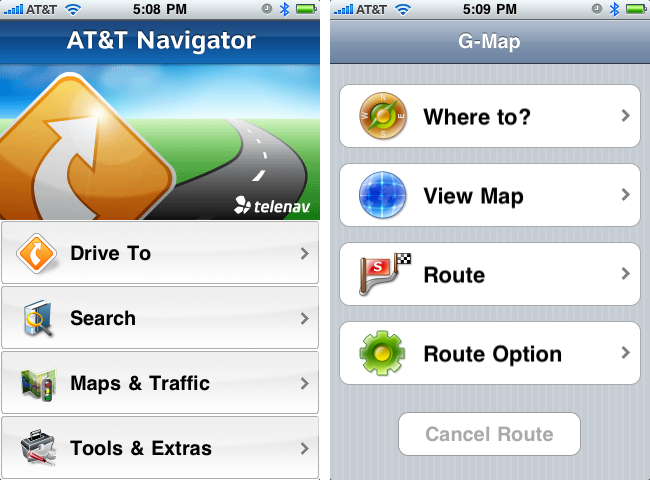
Although we've seen additional apps from TomTom and Navigon (and probably others) appear since I started this review, the first two GPS navigation apps for the iPhone were AT&T Navigator and G-Map from XRoad, and those are where I'll start. I hope to look at the others soon.
AT&T Navigator is a free app from AT&T, but requires a $9.99 monthly service charge. I hate that. G-Map costs $34.99 and consumes 846 MB of space, but requires no monthly fee. During a recent trip from Ithaca, NY to Boston, MA, I tested both, sometimes simultaneously with a Garmin nuvi 255W, which I reviewed a year ago (see "Garmin nuvi 255W Focuses on Navigation," 2008-08-07).
Online vs. Offline -- The first major difference between AT&T Navigator and G-Map - and all other standalone GPS devices, for that matter - is that AT&T Navigator stores hardly any information on your iPhone. Instead, it requires constant communication with AT&T's servers to download route information.
Needless to say, this can be a significant limitation if you drive in areas that lack cellular coverage, as is true of parts of upstate New York. There were a few times that AT&T Navigator was unable to connect, but luckily, none of those times coincided with a turn. During later testing in Ithaca, where cell service is often spotty, there were times I couldn't even get AT&T Navigator to load, due to the lack of service.
I'm surprised that the AT&T Navigator app doesn't download and cache the entire route upon starting, so that it could rely at least on cached instructions if connectivity was lost, throwing up its hands only if you deviated from the cached route.
G-Map didn't suffer from the same limitation, of course, but the tradeoff is that it requires 846 MB of space on the iPhone... for just the East Coast of the United States. That's a large percentage of the iPhone's space to allot to a single app, although you could of course load and unload it as necessary. If you want additional maps from G-Map, you must buy separate apps.
In contrast, the Garmin nuvi 255W contains maps for all of North America or Europe (depending on model), and a card slot lets you add even more maps. Score one for the standalone GPS.
Finding Destinations -- Aside from actual navigating, the primary interaction you have with any GPS is locating your destinations. GPSes offer several basic ways of finding locations, of which entering addresses and looking up points-of-interest are the most common.
Here's where I hoped the iPhone apps would prove significantly easier to use than the Garmin nuvi 255W, because, although it has a touch screen and a large database of points-of-interest, there's no question that its interface is clumsy, and it doesn't integrate with your normal contact database.
Although I could swear this wasn't true of the initial release of AT&T Navigator, the app now offers direct integration with your contacts list, which is huge. Most of the time, when you're going to someone's house, you already have their address in Contacts, and if you don't, it's easy to enter, either via the iPhone itself or in Address Book on the Mac.
If you do need to type an address into AT&T Navigator, it provides a screen with four fields - house number and street, city, state, and ZIP - and a keyboard for entering information. It's easy to move from field to field, and the app even guesses at likely results as you type. You don't even have to fill in all the fields: city and state or ZIP is sufficient to go to a town.
There is an alternative - you can call an AT&T voice response system that will attempt (poorly) to do speech recognition and walk you through finding your destination. I'm sure there are people who like using these systems, but I prefer ingesting lumps of wasabi when I'm feeling masochistic.
Oddly, G-Map has no integration with Contacts, which is a shame, given that its awkward interface makes the Garmin nuvi look polished. Instead of the fields in AT&T Navigator, G-Map makes you enter the street name and the house number on successive screens, and if you need to change the city or state from the previous search, doing so requires entering data on two more screens. Since all the screens look pretty much the same, you have to read carefully to figure out which screen you're on at any given time. Score one for AT&T Navigator.
AT&T Navigator also won out when it came time to find businesses and other points-of-interest. Since G-Map must carry its point-of-interest database along with it, it isn't nearly as comprehensive as AT&T's, which can live on AT&T's servers. Some categories I searched - like car rentals and hardware stores - were completely barren for Ithaca in G-Map, but had numerous entries in AT&T Navigator. In other categories, such as gas stations, both apps performed acceptably.
Plus, AT&T Navigator showed ratings for at least some businesses, which is a help when you're on a trip and trying to decide between restaurants. Unfortunately, you cannot rate business from within the app itself, which would be helpful; AT&T claims in its FAQ that you can do so from the Tools/Extra menu, but that's apparently untrue of the iPhone app.
G-Map did have one significant advantage over AT&T Navigator when searching points-of-interest. Since it didn't have to query remote servers over what could be a slow or nonexistent cellular connection, results were instantaneous. Many times I found myself annoyed at how long it took for AT&T Navigator to retrieve the results of my search.
Time Delay Navigation -- Here's the real crux of the matter - would I rely on these apps for directions in an unfamiliar city. The answer is yes, but not without some hesitation. Here's why.
The iPhone's GPS capabilities are certainly the stuff of science fiction when viewed from the perspective of what was possible 10 or 15 years ago. But compared to a modern-day car navigation GPS unit, the iPhone simply doesn't compete. To be specific, it's not as accurate as the Garmin nuvi 255W I was using as my control, and as a result, the GPS apps are more likely to get your position slightly off and take longer to notice if you make a turn that deviates from the current route.
Although it varied, my experience was that G-Map recovered from an unexpected turn more quickly than AT&T Navigator, often within 5 seconds, undoubtedly thanks to its local database.
AT&T Navigator had to notice the incorrect turn, transmit the new location to AT&T's servers, receive the new route back, and display it. That could take up to 30 seconds, which I found highly troubling in some situations.
If you're on a slow-moving freeway with few exits, 30 seconds may not matter, but if you're on a busy city street, you could miss an important turn or simply be more at risk of an accident. My experience with the standalone devices is that they usually recover within a few seconds, and in any event quickly enough that there's no more stress added to the situation.
G-Map wins on two counts here, in fact. Its route recalculation is faster, and because its maps contain more details - specifically more street names - than AT&T Navigator's maps, you can glance at the screen and see more of what's around you.
Routes -- Some trips aren't simple, if you need to make several stops along the way, and in other situations, you may need to consult a route list to ensure the directions make sense.
AT&T Navigator offers useful route summaries, both in text and in map form. You can also see a traffic summary that supposedly shows traffic delays, and you can ask it to avoid particular segments of the route. It's a clean interface, and easy to use under pressure, which is often the situation when you're consulting the route list.
In contrast, G-Map can show you a list of intersections along with a closeup of the turn, but the list lacks distances and turn directions, so it's not useful on its own. It can also preview a route graphically, showing how you'd drive. You can increase the speed so it's not as slow as actually driving would be, but it's still tedious to watch.
G-Map also enables you to create multi-point routes. I find that I generally just go from one point to the next, reprogramming the GPS once I'm ready to head out to the next destination, but I'm sure there are instances where a predefined route would be useful. AT&T Navigator has no such feature.
Speak Up -- I appreciate the visual maps provided by these apps, and both are totally usable, but the real utility of a car navigation GPS is its capability to speak directions to you, so you can keep your eyes on the road.
AT&T Navigator works as expected, reading both directions and street names (this is optional, though the default). Unfortunately, and this may be because of needing to download data from AT&T's servers, the voice quality is poor. I had no trouble understanding the AT&T Navigator voice, but the difference was obvious once I switched to G-Map, which has a much clearer voice.
Alas, G-Map can read only directions audibly, leaving you to glance at the map if you're uncertain which of two upcoming left turns it means. It does play a two-note tone every time you come to a turn (an audible interface element pioneered by Magellan), which helps.
AT&T Navigator won out in another way as well. If you want to listen to music or a podcast while driving, you can run the iPod app in the background, and AT&T Navigator will pause the music to speak some directions, then start playback again. The only downside is that AT&T Navigator is one of the chattiest GPS navigators I've ever used, so the constant pausing and playing was almost more annoying than it was worth. On one trip I shut it off entirely because I couldn't stand the constant interruptions from the low-quality voice.
Weirdly, G-Map not only wouldn't allow me to play music in the background - it just didn't work - the app's voice directions stopped working entirely if I plugged my car's cassette adapter into the iPhone's headphone jack. Since it was impossible to hear AT&T Navigator unless I ran it through the car stereo, this threw me for some time.
Neither app offers choices of voices, as do the standalone GPS devices, most notably TomTom's units, which let you download custom voices and even record yourself. Both apps offer a basic female voice, which is fine. AT&T Navigator does offer the option of English or Spanish.
More Power, Scotty! One area in which neither iPhone app could excel was in power usage. Actually relying on the app to give you directions requires that it keep the GPS chip and the screen active at all times, which drops battery life to about 2 hours.
The battery-powered standalone GPS units I've tested aren't notably better, but of course, if you let your iPhone run out of power, you've lost more than just your navigation help.
AT&T Navigator can dim or even black the screen, but that may not be safe, since you're most likely to want to see the map when you're in a confusing situation, and that's the worst time to need to fiddle with the iPhone.
So if you're going to use any iPhone GPS app, make sure to get yourself some sort of car charging device so you can be sure your iPhone will be fully juiced up at the end of the trip.
Various Nits -- Along with the criticisms I've noted so far, they also suffer from a number of minor nits, some which may disappear in future versions, but others of which are artifacts of the iPhone platform.
Still Looking -- Overall, although both apps would clearly do the job in the end, neither gave me the confidence to drive in the Boston metropolitan area - I continually wimped out and retreated to the Garmin nuvi 255W, which has never let me down in a major way.
The skinflint in me can't stomach recommending AT&T Navigator unless you're really good about canceling the service when you won't be needing it. At $9.99 per month, a year of use would make it more expensive even than the pricey TomTom ($99.99) and Navigon ($89.99) apps.
And while G-Map's (introductory) $34.99 price is more appealing, its clumsy interface, lack of integration with Contacts, and inability to read street names make it a less-than-ideal choice. Plus, if you regularly travel on both coasts and Canada, you'd need multiple apps that would cost the same as the TomTom app. G-Map does have apps that cover more limited areas - California, New York/New Jersey, Florida/Puerto Rico, Texas, Wisconsin/Illinois, Minnesota/Indiana, and Canada - and that cost only $19.99 and weigh in around 100 MB.
But in the end, I'm canceling the AT&T service - I just don't need to pay $9.99 for a trip or two per month - and I'll be using G-Map until it's time to review the next iPhone GPS app.
Read and post comments about this article | Tweet this article
[Update: As of 1 PM Eastern, Google is reporting all problems with Gmail as resolved, and indeed, the banner about Contacts being offline is gone, and sending and receiving mail appears to be working normally. -Adam]
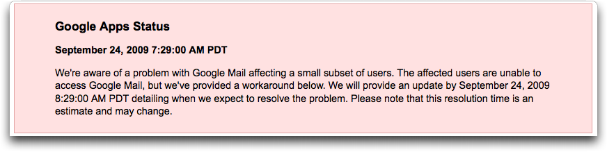
Although Gmail isn't rejecting connections for me, as it did the last time it went down three weeks ago (see "Gmail Web Interface Down; IMAP Working," 2009-09-01), we're seeing distinct problems as of about 10 AM Eastern.
Mail is slow to come in, but more troubling is that Gmail's Web interface is having trouble sending messages. And since sending email is essentially a modal action in Gmail (you can't do anything else in the Web interface while it tries to send), sending problems render Gmail unusable. I was able to save drafts several times, and messages would sometimes send and would sometimes display errors claiming they couldn't be sent.
Gmail is also displaying a banner that says Contacts are offline, which Google explains means that auto-complete may not work, the contact manager may not load, and chat may not work. Apparently, I've become highly dependent on auto-complete when sending messages, to judge from my stuttering when faced with an uncompleted name in my To field.
As of 10:30 AM Eastern, Google has updated the Apps Status Dashboard to indicate some issues with Gmail, and a banner on the Gmail Help home page indicates that Google is working on the problem.
As with the previous outage, IMAP access to Gmail seems unaffected, and whether or not it would be in any future scenario, keeping an email client like Mail downloading messages from Gmail via IMAP would mean that you'd at least have access to your older messages for reference while Google fixes the online problems.
As I wrote last time:
"The moral of the story - backup, backup, backup. The smart computer user who can't necessarily afford to be offline for a long period of time backs up not just data, but access methods. If Gmail's Web interface goes down, I can use IMAP. If Gmail stops working entirely, I can use my own server or my MobileMe account. If my cable modem goes down, I know where I'll take my MacBook for Internet access. And so on..."
Read and post comments about this article | Tweet this article
Don't get me wrong, I'm all in favor of privacy. But there are times and places when you very much want certain other people to know exactly where you are, without you having to do anything.
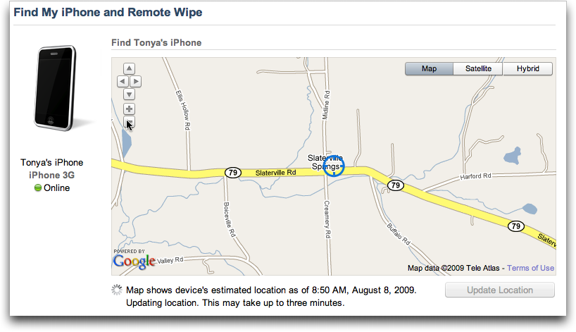
The release of Find My iPhone with iPhone OS 3.0 came at a perfect time for us, since Tonya got an iPhone at the start of the summer, just as she was beginning to train seriously for the 100-mile AIDS Ride for Life, an annual fundraising event around here. As the summer progressed, Tonya needed to do ever longer training rides that would take 3 to 7 hours and cover 30 to 75 miles. (For the record, on 12-Sep-09, she did the full 100 miles - an amazing achievement!)
During those rides, she always had her iPhone in her seat pack, turned on, but not attempting to run any special apps. When she stopped to drink or have a bite to eat, she would sometimes use Twitter to send me direct messages that would pop up on my iPhone courtesy of Boxcar, just so I knew she hadn't suffered a breakdown, injury, or accident.
But she didn't stop often, and it wasn't always convenient for her to pull the iPhone out, particularly if it was raining. So although I didn't particularly worry, there were a few times when she was quite late in returning home because she'd decided to ride further than expected, or she stopped longer than she thought she would.
On those occasions, and every so often during those long weekend rides, I'd log into her MobileMe account and use Find My iPhone to, well, find her iPhone. It was an easy way to check in and make sure everything was all right without interrupting her with a call or waiting for her to stop. Sometimes I'd even use Find My iPhone to display a message on her iPhone for the next time she pulled it out.
(The most annoying aspect of Find My iPhone is that MobileMe times out your login quickly, so if you want to check an hour later, you have to log in again, and the entire Web interface for that is fussy. Another annoyance is that Apple prevents you from accessing the Find My iPhone Web page from an iPhone, so once when we were meeting at friend's wedding party 60 miles away, I couldn't find her because I had only my iPhone for Internet access. It would have been helpful that time too, since she took a wrong turn and needed a pickup, but luckily there was sufficient cell service for a call to get through.)
Before I hear any outraged gasps - how could I invade Tonya's privacy in this way! - let's be clear: she explicitly asked me to check up on her with Find My iPhone and made sure I knew her MobileMe password so I could log in to her account to do so. We're happily married and while we don't go poking into each other's computers on a regular basis, we're both entirely fine with the fact that the other should have full access to everything, just in case. I'd hope that's more the norm than the exception among married couples.
Tonya was much more comfortable biking long distances from home on rural roads knowing that I would be likely to find her if she broke down in an area with extremely minimal cell service, and she felt less anxious about real threats like drunken target practice and hotrodding pickup trucks, not to mention intangible fears like swamp monsters.
I wonder if this tension between wanting privacy and wanting certain people to know your whereabouts at any arbitrary time might be somewhat gender-based. As a guy, I don't often worry about making sure people know where I am when I go on long runs, and I'm not really afraid of anything out on the roads. But a number of the female athletes I know prefer to have someone know where they are when they're training alone, and if carrying an iPhone enables a spouse to check in from afar, that's a good thing.
I'd go further and suggest that Apple should open up Find My iPhone slightly, so you could give select people access to it without letting them into your entire MobileMe account. Of course, you'd have to be able to revoke those privileges easily too, and it should probably alert you whenever your location has been requested, and by whom.
Even better, Apple could make an iPhone app for it so you could use it while out and about with the people you trust. After all, if I'd had to go find Tonya 30 miles from home, I wouldn't have any way of determining if her location had changed from when I left the house, and in a scary accident scenario, I could see wanting updated location information.
Another nice addition might be a Map My iPhone feature that would display your iPhone's location at user-specified intervals, again, only to those to whom you'd given access. Especially in rural upstate New York, where cell service is often poor or nonexistent, being able to see a last known location with a time stamp could be useful.
If you're looking for features along these lines now, AT&T does offer the FamilyMap service for locating your family's phones. It works with all AT&T phones, including the iPhone, though it doesn't take advantage of the iPhone's GPS capabilities and is thus limited to less-accurate cell tower triangulation. It costs $9.99 per month to locate two phones, or $14.99 per month for five phones.
Read and post comments about this article | Tweet this article
Previous Issue | Search TidBITS | TidBITS Home Page | Next Issue