 |
|
|
Be sure to read the special notice on Captian Nelson and the Malcolm Baldrige.
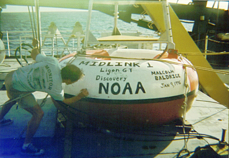
Dear MidLink Readers -

On Tuesday, January 9, 1996 the NOAA Ship Malcolm Baldrige deployed the last
ATLAS buoy on its around-the-world cruise.  While this deployment marked a
significant milestone for those of us on the ship, the event was also
noteworthy, because the buoy, that is now anchored in approximate position,
latitude 02-degrees 02-minutes North, longitude 110-degrees 07-minutes West,
was christened "MidLink-1" before launching.  But more about that later.  Let
me tell you a little bit about the scientific project that has been keeping
us busy for the last two months of our cruise.

Since then Malcolm Baldrige departed Darwin, Australia on 21 November 1995,
the ship has been operating in the Equatorial Pacific Ocean to recover,
deploy, and repair buoys that are part of the Tropcal Ocean Atmosphere (TAO)
array.  This ocean observing system has been established over the last 10
years as part of the international Tropical Ocean Global Atmosphere (TOGA)
program.  The TAO array started out with only seven buoys when the program
began in 1985 and was expanded to 69 buoys when the complete ocean observing
system became fully operational in December 1994.  Now that the observing
system is operational, several ships, from the different countries that are
participating in the program, are required to visit and maintain these 69
buoys each year, to ensure that the observing system continues to collect and
report data without interruption.

The main purpose of the TOGA/TAO program has been to establish a network of
buoys equipped with instruments that report oceanographic and surface
meteorological variables in real-time, to monitor the ocean-atmosphere system
in the tropical Pacific ocean so that we can improve our ability to
understand and to predict seasonal and year-to-year changes in climate that
originate in the tropics.  Most notably the observations from these buoys are
being used to predict the onset, evolution, and end of the El Nino
phenomenon, a major perturbation in the ocean-atmosphere system in the
Pacific Ocean that causes world-wide changes in weather and climate.

The ATLAS (Autonomous Temperature Line Acquisition System) buoys in the TAO
observing array span the width of the Pacific Ocean, or approximately one-
third of the circumference of the Earth, from longitude 095-degrees West near
the Galapagos Islands to longitude 137-degrees East off the north coast of
New Guinea.  The surface buoys are anchored in water depths of 3000 meters to
5500 meters, every 2-degrees to 3-degrees of latitude between 8-degrees North
and 8-degrees South along lines of longitude that are separated by 10-degrees
to 15-degrees of longitude.  During November and December 1995 and January
1996, the Malcolm Baldrige visited ATLAS buoys located along longitudes 165-
degrees East, 180-degrees, 170-degrees West, 155-degrees West, 125-degrees
West, 110-degrees West, and 095-degrees West.  During our two cruises, we
have visited a total of 27 buoys, or about 40% of the total number of buoys
in the TAO array along 7 of the 11 meridional lines of buoys in the TAO
array.

Each one of the ATLAS moorings consists of a surface toroidal (doughnut-
shaped) buoy, 2.3 meters in diameter, that floats on the surface of the ocean
and is attached to a 4200 lbs anchor on the bottom of ocean by a long length
of steel cable and nylon mooring line.  An aluminum tower that stands
approximately 4 meters high is mounted on the surface buoy.  The tower
supports most of the instruments that are used to make the surface
meteorological measurements.  The anchor is made up of several old, discarded
railroad wheels.  An acoustic release is attached between the anchor and the
end of the nylon mooring line that leads to the surface buoy.  The acoustic
release can be activated by coded signals sent through the water from a
command unit mounted on the ship.  When we want to recover one of these ATLAS
moorings, so that we can replace the buoy and all of the instruments, the
acoustic release is triggered, the latch that is attached to the anchor lets
go, and the entire mooring floats free, so that we are able to recover the
surface buoy, the underwater instruments, and all of the mooring cable and
nylon mooring line from the ocean.

Each of the ATLAS buoys is equipped with an anemometer to measure near-
surface wind speed and direction, and other instruments to measure air
temperature, relative humidity, and sea surface temperature.  A thermistor
cable extends below the surface buoy, and thermistors are located at 10-
different depths along this cable to measure the temperature of the upper
ocean between the surface and 500 meters depth.  A thermistor is a small
electronic device in which changes in temperature produce changes in
electrical resistance.  An electronic signal that is directly related to the
temperature is sent up the cable to an instrument package on the buoy, where
the temperature data are recorded and stored for later transmission.  The
thermistor cable is attached to the upper end of the nylon mooring line, and
the nylon mooring line leads down to the anchor.  These buoys are anchored in water depths of between 3000 meters and 5500 meters, so often when we are putting a new buoy in place, we have almost 2 1/2 miles of nylon line stretched out behind the ship before we release the 2-ton anchor to deploy the buoy into its intended position.

The oceanographic and meteorological data that are measured by the various
instruments attached to the ATLAS buoys are collected and stored in a
computer on the buoy and then the data are compressed and transmitted
electronically to shore several times per day via the NOAA polar-orbiting
satellites.  These data are utilized immediately for the purpose of making
the daily global weather forecasts at several national weather forecasting
centers around the world.  The oceanographic and meterological data are also
used to make climate predictions and for research into the effects of the
tropical ocean-atmosphere system on global weather and global climate
changes.

Now back to the MidLink-1 buoy.  Before this new ATLAS buoy was deployed in
position 02-02 N, 110-07 W, we decided to add a few identifying names to the
buoy.  The surface toroid is normally painted two-tone orange and white for
identification, with the word "ATLAS" painted on the side.  Well, in addition
to "ATLAS," the buoy is now adorned with the words, MidLink-1, Ligon GT,
and Discovery to identify the "owners" of this buoy as the readers of
MidLink Magazine and the students of Ligon GT Magnet Middle School in Raleigh,
North Carolina and Discovery Middle School in Orlando, Florida.  We also painted
the ship's name Malcolm Baldrige and NOAA on the side, and added the
date that we launched the buoy, 9 January 1996.  Several of us autographed the
buoy as well, before we put it into the water.

You might ask, "Who's going to see this buoy?"  Well, just about six months
to a year from now, other NOAA scientists and crew members on our newest
research ship, the NOAA Ship Ka'imimoana (Hawaiian name for "Ocean Searcher") will visit and recover this buoy, and our paint job will still be there to
greet them.  In fact, those of us who will still be on the Malcolm Baldrige
this summer may get a chance to visit this buoy again in July 1996, but it
will be too soon to pull the buoy out of the water.  Besides, the longer that
we leave the buoy in the water, the more fish will be attracted to the buoy.
There will be a real fishing derby for the next ship that visits the buoy.
But that's another story.

But more than just having the MidLink name on the buoy, you now have the
opportunity to watch your buoy in action.  This buoy was anchored in
position, latitude 02-02 N and longitude 110-07 W, in a water depth of 3924
meters, and the buoy was released from the ship into its anchored position at
2116 (9:16 PM) on Tuesday 9 January 1996, just about a week ago.  At the time
of our last sighting of the buoy, the instruments were recording winds from
150 degrees at 10 knots, an air temperature of 24.0 degrees Celsius, a sea
surface temperature of 25.6 degrees Celsius, and a relative humidity of 85
percent.

For all of you students who are expert WEB surfers, take a look at the
 NOAA/PMEL TAO page.

You can also look at the El-Nino home page.


The home pages were created by scientists at the NOAA Pacific Marine
Environmental Laboratory (PMEL) in Seattle, Washington as a very convenient
way to distribute the oceanograhic and meteorological data collected from the
69 TAO moorings as well as the analyzed products derived from these real-time
data.  In addition to the buoy data, the home page contains information on
the TAO Project, information for fishermen (we have seen lots of evidence
that fish, such as yellowfin tuna and mahi mahi [dolphin fish] collect around
these buoys and fishermen sometimes tie up to these buoys to fish), and
information on El Nino.  This information is being accessed by other
scientists, fishermen, and students like yourselves who are curious and
interested in science and in what causes the changes in the Earth's weather
and climate system that we experience.

On the El Nino home page you can look for information on the effects of El
Nino on global climate.  You will be able to look at the most recent
satellite images of sea surface temperature in the Equatorial Pacific Ocean.
You'll be able to monitor the data that is being collected by your buoy at
2N, 110W in the eastern part of the TAO array, and you'll be able to watch
the changes in the tropical oceanic and atmospheric patterns and check to see
if another El Nino is developing.

As scientists have studied the El Nino phenomenon over the past 4 decades and
longer, we have come to realize that El Nino is not only a local change in
the ocean conditions off Peru and Ecuador, but more importantly, El Nino
represents a major disruption in the entire ocean-atmosphere system in the
tropical Pacific Ocean, that has important consequences for weather and
climate around the globe.  For example, the heavy rains and flooding that
occurred along the coast of California in January and February last year,
were likely the result of the remnants of the El Nino that was still
occurring in late 1994.

     There also appears to be a strong link between El Nino and the occurrences
of hurricanes in the Atlantic Ocean.  During El Nino
years, there are fewer hurricanes in the Atlantic Ocean than during non-El
Nino years.  For those of you who live in Florida and along the east coast of
the U.S., I'm sure that you remember that the 1995 hurricane season was very
active, with about 19 named storms during the year.  [Fortunately for us on
the Malcolm Baldrige, we were working in the Indian Ocean, far from the
breeding grounds of the Atlantic hurricanes.]  Well, 1995 was a non-El Nino,
or more "normal" year, and the number of hurricanes increased dramatically
from the few numbers of hurricanes that occurred in 1993 and 1994, which were
El Nino years.

When conditions in the tropical Pacific Ocean are "normal", the trade winds
over the ocean blow from east to west and warm surface water is piled up in
the western tropical Pacific Ocean, so that the sea surface stands just about
one-half meter higher near Indonesia than it does near Ecuador.  The sea
surface temperature near Indonesia is about 30-degrees Celsius, and is just
about 8-degrees Celsius warmer than the cold, upwelled waters near the coast
of South America, that are about 21 to 23-degrees Celsius.  Heavy rainfall
occurs over the very warm waters near Indonesia, and the eastern Pacific
Ocean near South America is relatively dry.

During an El Nino, the trade winds that normally blow from east to west
across the tropical Pacific Ocean relax, or sometimes reverse and the wind
may actually blow from west to east for short periods.  During these periods,
the warm pool of water "sloshes" back along the Equator.  The waters along
the coast of South America warm up and the warm surface layer thickens,
suppressing the cold nutrient rich waters much deeper in the water column.
The warm waters flow poleward in both hemispheres; southward along the coasts
of Ecuador, Peru, and Chile, and northward along the coasts of Mexico and the
United States.  Fish catches off the coasts of Ecuador and Peru rapidly
decline, and the coast of California is usually invaded by tropcial species
of fish that aren't normally found in these colder waters.  Heavy rainfall,
that usually falls in the western tropical Pacific Ocean during normal years,
follows the path of the warm pool of water eastward, and during El Nino
years, flooding occurs in Peru and quite often in California, as it did
during the winter 1994-95, while Indonesia and Australia suffer through
devastating droughts.

If fluctuations in climate such as El Nino simply affected the ocean and
atmosphere in the tropical Pacific, you and I might not pay too much
attention to the changes.  But as I tried to indicate, shifts in temperature
and wind patterns in the Pacific Ocean can affect the weather and climate
where you or I live in the eastern United States, thousands of miles away.
For example, most El Nino winters are mild over western Canada and the
northern United States, while the southern United States is usually wet.
I've also tried to indicate that these changes in weather and climate are
usually not just small or subtle changes, but they can be very damaging and
devastating.  Off Peru, the entire fishery for anchovy collapsed after the
strong El Nino in 1972.  In 1982-83, another very strong El Nino caused
billions of dollars worth of damage due to 1) flooding in Peru, Ecuador,
Bolivia, and the U.S. Gulf coast states, 2) hurricanes in Hawaii and Tahiti,
and 3) fires and drought in Africa, India, Sri Lanka, Indonesia, and
Australia.

Think about how useful it would be if we could accurately predict 6-months to
a year ahead of time the onset, strength, and duration of an El Nino, and
which parts of the world are going to be warmer and wetter than normal, and
which countries are going to be dryer than normal.  Well that's just exactly
where state-of-the-art science is taking us.  By combining the information
that we observe from the 69 surface buoys in the Equatorial Pacific Ocean TAO
array with accurate and complex computer models about how the ocean and
atmosphere system work, scientists are now able to provide better indications
of the climatic conditions that will prevail during the next one or two
seasons than simply assuming that rainfall and temperature will be "normal."
More importantly, these rudimentary predictions of the onset of El Nino are
already being used by the Peruvian government, for example, to make decisions
that will help avoid the agricultural and fishing disasters that have
occurred in Peru in the past.  Two of the most important crops in Peru are
rice and cotton.  Rice thrives in wet conditions, while cotton can survive
drier weather.  If a forecast for an El Nino [wet year] is issued, crops may
be shifted to rice to maximize production, whereas, during a non-El Nino
year, more cotton may be planted.  Similarly, during non-El Nino years,
fishing is usually very productive off Peru, so fishermen would take to their
boats to earn their living.  However, during a wet, El Nino year, the
fishermen might leave their boats high and dry, and take up the plow on a
farm.

If we can anticipate and predict how climate will change from one year to the
next, then we can develop better ways to manage agriculture, fisheries, our
precious and dwindling fresh water supplies, and other resources that are
affected by weather and climate.  By incorporating the products of science,
such as climate predictions, into our management decisions, we will all
become better adapted to the irregular and sometimes puzzling pulses of
climate.

Hang Ten and have fun surfing the WEB learning about MidLink-1 and an El
Nino.

Your Friend and Shipmate,
 Captain Craig S. Nelson, NOAA
 Commanding Officer
 NOAA Ship Malcolm Baldrige

Back to "Launching MidLink-1" Menu
Back to the MidLink-1 Page
Back to the MidLink Home Page
Back to the Baldrige Home Page


Page created by
Matt Vepraskas and Mac Young
701 E. Lenoir St.
Raleigh, NC 27601
USA