 Trigance
Provence-Beyond (Beyond the French Riviera) ®
Var (83840)
Population: 120
Altitude: 800 m
Nearby:
[ Bargème | Castellane | Comps-sur-Artuby | Grand Canyon du Verdon ]
Photos:
The village, below the castle (20k)
Kids playing ball in the at the church square (18k)
Church and belltower through the trees (30k)
Below: [ History | Dates | Hiking | Lodging ]
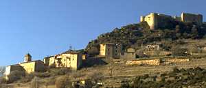 Your first view of Trigance as you arrive from the north or the south along the Jabron river will be the crenellated castle sitting on top of the hill, giving you the feeling that there should be knights riding in armor up the valley. Coming closer, the view of the medieval village snuggled up at the base of the feudal castle only reinforces the atmosphere of a trip back to the past.
The Jabron valley is wide here, and isolated enough that there are buzzards, golden eagles and hawks hunting the fields between the road and the river. The road to the village winds back and forth up the open hillside, giving you an excellent view of the village, the castle and the surrounding hills. The village is a mixture old stone houses, freshly rebuilt stone buildings and a few run-down stone walls, with the narrow streets terracing up the steep hill between them and the castle proudly at the top.
A snug little square in the center of the village has all the necessary shops, including the Bar Piccolo with its outdoor tables and umbrellas. Even in the winter, with the visitors gone, the village has a feeling of life and activity, with people shopping and visiting and kids playing at the church square.
The village also hosts a gîte for hikers and a large hotel-restaurant.
History
Prehistoric:
There are vestiges of iron-age tombs at Soleils, 3 km to the north.
First record, 814: Tregentia
The name means "the three braids", from the provençale "gentia", for braid (or ganse, in French).
Medieval: the fief of the Comte de Provence, and then, in succession,
the monks of St. Victor, the Raimondis, Demandoix, Valbelle, Ste. Tulle and Castellane.
There's a legend of a Templier treasure hidden in the castle.
The castle itself has parts that date back to the 12th, 15th and 16th centuries.
Dates
Fête: 16 August (St. Roch)
Foire: 8 July
Grotto and Waterfall
Pas-de-la-Chapelle
Hiking
Maps: IGN 3442 est (1:25,000); Didier Richard #19 (1:50,000).
Trigance is on the Jabron river, only 6 km (by road) before it flows into the Verdon.
The region is both hilly and mountainous, and largely forested.
The Grande Randonnée GR49 passes through the village. To the east, the GR goes past Jabron, Bargème, la Bastides, and eventually Mons. To the west, the trail goes to the Crête d'Arme Veille (old-weapon ridge), about 1250 m high, and then north to the top of the Grand Canyon du Verdon.
From the village, other trails go north up the west side of the Jabron to the Verdon river. You can also take the GR49 south about one km, to find a branching trail that goes northeast through the hills and forests, connecting with several other trails towards the mountains of Beysse, Robion and Destourbes.