 Comps-sur-Artuby
Provence-Beyond (Beyond the French Riviera) ®
Var (83840)
Population: 272
Altitude: 900 m
Nearby:
[ Bargème | Bargemon | Trigance ]
Photos:
A wider view of the village (16k)
A pastel fountain running double (18k)
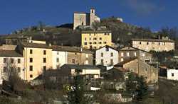 Comps-sur-Artuby seems a fairly large town, sitting in a wide pass through the hills.
It was originally a perched village, but after its checkered history it settled into its current location.
Located at a remote backcountry crossroads, the village doesn't seem interesting at first glance.
But, wandering through the narrow back streets that flow out over the adjacent hills with their churches and chapelles, the village shows a pleasent charm.
Inside the village, with plenty of shops and stores of all kinds, the buildings frame little squares and fountains, and some buildings are painted in bright, contrasting pastels, looking fresh and friendly.
Outside the village, wide paths take you to views of hills forested with Scots pine and beech, accented with long, deep gorges walled with low cliffs of white rock.
Comps-sur-Artuby seems a fairly large town, sitting in a wide pass through the hills.
It was originally a perched village, but after its checkered history it settled into its current location.
Located at a remote backcountry crossroads, the village doesn't seem interesting at first glance.
But, wandering through the narrow back streets that flow out over the adjacent hills with their churches and chapelles, the village shows a pleasent charm.
Inside the village, with plenty of shops and stores of all kinds, the buildings frame little squares and fountains, and some buildings are painted in bright, contrasting pastels, looking fresh and friendly.
Outside the village, wide paths take you to views of hills forested with Scots pine and beech, accented with long, deep gorges walled with low cliffs of white rock.
There are plenty of churches and chapelles, including the 12th-century romanesque church called the Templiers, the romanesque chapelle St-Jean and the Provençal-romanesque chapelle St-Didier.
Grottos.
The hills around Comps and the white-cliffed gorge of the Artuby contain several grottos, including the Grotte des Gnomines to the south and the Aven de la Souche about 3 km to the east.
History
Prehistoric:
There was a chalcolithic and an iron-age presence in Comps.
First record, 11th century: in Cumbis
Medieval: controlled by the Hospitalers (Knights Hospitalers) in the 13th century.
Charles de Duras laid siege to Comps. When he finally conquered it, the inhabitants fled, eventually creating a number of smaller hamlets nearby.
After a donation by the Reine Jeanne, Duras shared control of the domain with the Pontevès.
Comps was the home of Arnaud (1163) and Bertrand (1244), both grand masters of Malta.
Another luminary of Comps was père Pellas, who in 1723 wrote the first Provençal dictionary.
Dates
Market day: tuesday
Fête: 7-9 Sept, with a pilgrimage to the chapelle N.D.-de-la-Galine.
Hiking
Maps: IGN 3543 ouest (1:25,000); Didier Richard #19 (1:50,000).
The GR49 passes east-west along the Jabron river, about 3 km north of Comps.
There are several local hiking trails, some marked with a blue blaze rather than the traditional yellow, and the trails cross through the Forêt de Duou to the east and the
Bois de Fayet to the west.