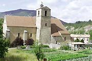
 Senez
SenezProvence-Beyond (Beyond the French Riviera) ®
Alpes-de-Haute-Provence (04330)
Population: 121
Altitude: 780 m
Michelin map: #245 "France Provence-Cote d'Azur"
Nearby:
[ Barrème 5 km | Castellane 19 | Digne-les-Bains 35 | Saint André-les-Alpes 18 | Route Napoléon | Clue de Taulanne 10 ]
Photos:
1 Village church and garden (49 k)
2 Bridge entrance to the village (46 k)
3 Arched bridge across the stream (44 k)
4 Senez village in the hills (48 k)
5 The old church (47 k)
Below: [ History | Hiking | Lodging ]
 Senez is a very tiny little village, off to the side of the road between Castellane and Barrème, and you're likely to miss it if you're not paying attention. A small turn-off from the Route Napoleon, only 5 km south of Barrème, takes you over a lovely 17th-century stone hump-back bridge [photo-2] and down a short road to the village.
The center-piece of the village is the Romanesque Notre-Dame-de-l'assomption cathedral from the beginning of the 13th century. Our main photo (left) shows the side of the cathedral, looking across the vegetable gardens. photo-5 shows the front with its gothic doorway, from across the shady square.
Shady squares is what this little village is all about, and games of petanque, strolling on country lanes, hiking through gentle hills and relaxation. This obviously isn't a major tourist destination, but if your in the area, take a few minutes to stop here - - you'll leave happier than when you arrive.
History
Senez was a very ancient town, founded by the Gaulois. In Roman times, it was the chief town of the district, and numerous signs of Roman occupation have been found.
Medieval:
Senez was declared a bishopric in the 5th century, and was perpetually one of the poorest bishoprics in France. The bishop resisted attempts to attach Senez to Castellane or Vence, maintaining his independence until the Revolution. There was once a Templiers establishment at Senez,.
- Hiking
- Maps:
- Didier Richard (1/50,000) #19 "Haute Provence Verdon";
- IGN (1/25,000) #3441 OT "Digne-les-Bains"
A longer loop hike goes out the little road and continues west about 6 km to a junction with a hiking/riding trail at Barre de la Melle; turn right (northeast) to the Sommet de Tourrap (1240 m); at the junction of the forestry roads, follow the northeast road that loops back past Le Riou-d'Ourgeas and along the river to Senez.