 Clue de Taulanne
Provence-Beyond (Beyond the French Riviera) ®
Alpes-de-Haute-Provence (04)
Altitude: 1007 m
Nearby:
[ Barrème 8 km | Castellane 10 | Digne-les-Bains 38 | Senez 10 | Col de Leques 3 | Route Napoléon ]
Photos:
1 In the Clue de Taulanne, the road north passes through this hole in the rock. (24 k)
2 A view of the Clue de Taulanne, with the tunnel at the upper right. (26 k)
3 In the valley just below the road, the stream is small in the summer, leaving nice pools. (31 k)
4 Swimming in paradise - the 3 cool people in this cascade pool are Olivier, Monia and Bas. (29 k)
5 A small but lovely waterfall. (25 k)
6 Another cascade pool in the Clue de Taulanne. (25 k)
7 A third cascade pool in the Clue de Taulanne. (26 k)
8 A forth cascade- pool and three happy swimmers: Bas, Alexis and Olivier (27 k)
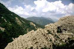 This is a beautiful, steep-sided canyon winds down from the Col des Leques, just outside of Castellane. The road runs along the side, at one point passing through a needle-eye hole in the rock wall (called Clue de la Roche Perchée). Our photo (left) is looking norht, where the Route Napoléon runs towards Barrème (8 km) and on to Digne (38 km). Back to the south 3 km is the Col des Leques (mountain pass), with hiking trails, and then the town of Castellane (19 km).
A fast-running stream flows down the bottom of the canyon, with small waterfalls and pools. Photos 4 through 8 show different waterfalls (cascades) and pools in the canyon, and how enjoyable they can be in the summer.
Photo 2 and photos 4 through 8 were contributed by Bas Bruning from Holland.