 Saorge
Provence-Beyond (Beyond the French Riviera) ®
Alpes-Maritimes (06540)
Population: 362
Altitude: 500 m
Nearby:
[ Breil-sur-Roya 12 km | Casterino | Fontan | St-Dalmas | Tende ]
[ Col de Turini | Mercantour | Roya Valley ]
Photos:
A larger view of the end of the village in the notch (24 k)
A panorama of the village, with a Gîte at the far left (22 k)
Below: [ History | Hiking ]
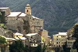 Saorge is a very beautiful medieval village perched along a narrow rock spur that juts out into the Vallée de la Roya, high above the river. Saorge is classed as one of the "40 most beautiful villages of France".
The N204 road from the south follows the very beautiful Roya river valley up through the Gorges de Saorge until the village appears, a horizontal line of buildings high on the mountainside, its back protected by the even higher mountains behind. Part of the village sits in a saddle of the spur, with a view to the north as well as south.
For access up to the village you need to drive on another 2 km to Fontan. Turn off to the right, across a lovely bridge over the Roya, and follow the road back south again as it climbs the side of the mountain and comes into the village from the north.
The railway station for the Nice-Cuneo train sits by itself, below the village, on the road up from Fontan. The dark ocre building and green shutters and doors fit perfectly on the green forested mountainside. Trains come and go by a tunnel into the rock at the south end of the station, and wind on up the valley to the north.
If you're driving, the "parking area" is up a steep road above the village. It's only a short walk, with a fantastic view, down to the village. A little wooden box at the end of the parking lot has free maps of the village.
The high, narrow houses, from the 15th-17th century, are ocre with some blue stone, and covered by dark-red slate roofs, the slate shaped as naturally as when they were chipped out of the mountains.
The main village streets traverse narrowly between the buildings at very different levels, with smaller streets and steps leading up and down between them. The view from anywhere in the village is spectacular, looking outward to snow-capped mountains in the middle distance (into May and June) and the deep gorge and rushing white-water river below.
From the top of the village at the northern end, the view is down across the roofs of the village itself. At least five lovely old bell towers extend up from the sea of red-tile roofs, with that of the Madone-del-Poggio out on a spur past the southeastern edge of the village. A colorful 17th-century monastery (called the Couvent des Franciscans) sits up high at the eastern end of the village.
Name
First record, 10th century: de Saurgio
History
Roman: There are Roman inscriptions on the St-Michel church.
Medieval: Saorge was in the Compté de Vintimille until 1258, when it was ceded to Provence. Later, under the Maison de Savoie, Tende was a fortified town guarding the Vallée de la Roya, and was considered impregnable.
Tende remained under the control of the Austro-Piémontaise until 1794, when Massena destroyed the defenses and brought it into the Compté de Nice.
- Numbers
- Bureau du Tourisme - 06540 Fontan; tel: (33) 493 04 50 01
- Mairie - 06540 Saorge; tel: (33) 493 04 51 23
- Hiking
- Maps:
- IGN (1:25,000) 3841 OT "Vallée de la Roya"
- Didier Richard (1:50,000) #9 "Mercantour"
-
 The GR52A (Grande Randonnée) climbs up through the village to the monastery at the top, passing it to the left to go by the gîte and out into the mountains to the northeast. The GR52A curves around to the north, passing through the mountains at up to 1300 m before dropping down to la Brigue (760 m).
The GR52A also goes south from the village, following the road out past the Madone-del-Poggio. The trail follows the mountains south, along (above) the east side of the Roya, to Breil-sur-Roya, then crosses over to the east and climbs up to the Col de Brouis.
There are plenty of (rugged) loop hikes in the mountains to the northeast and the southeast of Saorge, many branching off from the GR52A.
Behind the railway station below the village, local hiking trails are marked for Baisse de Cachin and for Saorge.
The GR52A (Grande Randonnée) climbs up through the village to the monastery at the top, passing it to the left to go by the gîte and out into the mountains to the northeast. The GR52A curves around to the north, passing through the mountains at up to 1300 m before dropping down to la Brigue (760 m).
The GR52A also goes south from the village, following the road out past the Madone-del-Poggio. The trail follows the mountains south, along (above) the east side of the Roya, to Breil-sur-Roya, then crosses over to the east and climbs up to the Col de Brouis.
There are plenty of (rugged) loop hikes in the mountains to the northeast and the southeast of Saorge, many branching off from the GR52A.
Behind the railway station below the village, local hiking trails are marked for Baisse de Cachin and for Saorge.