 Casterino
Provence-Beyond (Beyond the French Riviera) ®
Alpes-Maritimes (06430)
Commune of Tende
Nearby:
[ Breil-sur-Roya 30 km | Fontan 21 | Saorge | St-Dalmas 13 | Tende 17 ]
[ Mercantour | Roya Valley ]
Photos:
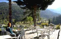
1 A terrace café in "downtown" Casterino (38 k)
2 A mountain trail passing old war bunkers (23 k)
3 A hiking signpost in the mountains, with bull, cow and calf (28 k)
4 VTT cyclists on a trail at about 2000 m. (27 k)
5 Sheep at a watering trough in the mountains (32 k)
6 Wooden bridge over a mountain stream beside the road (33 k)
 Casterino, also in the commune of Tende, is 13 km west of St-Dalmas along the little D91 road. The road starts up past the beautiful old railway station in Saint-Dalmas, and winds into the hills 10 km to the Lac des Mesches. Parking at the lake, above the dam, is a popular site for starting walks and hikes in the woods.
Another 3 km on a slightly narrower road takes you to the cluster of auberges and hotels at Casterino, sitting in a magnificent valley along the swift little river. Our photo-1 (above) was taken at the terrace of one of the auberges, looking back towards the south.
Tende, St. Dalmas and Casterino are centers for excursions into the Mercantour. We took a four-hour loop hike into the mountains to the east, up to the Baisse de Peirefique (2030 m) where we found the old bunkers and a bovine family shown in photos 2 and 3. Our hike came south to Baisse d'Ourne (2040 m) and down through the forests to our starting point.