 Flayosc
Provence-Beyond (Beyond the French Riviera) ®
Var (83780)
Population: 3230
Altitude: 235 m
Nearby:
[ Ampus 14 km | Châteaudouble 18 | Draguignan 7 | Fréjus 35 | Lorgues 7 | Nice 96 | Tourtour 15 | Villecroze 14 ]
Photos:
1 A panoramic view of the village (29 k)
2 The fountain at the Place de la République (31 k)
3 A lovely "lavoir" (19 k)
4 The church bell tower with campanile on top (19 k)
5 A tractor load of grapes through the center of the village (23 k)
Below: [ History | Dolls | Mills, Wine | Sites | Dates-Numbers | Hiking | Lodging ]
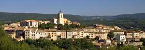 Flayosc is a medieval village perched on a low, conical hill a few km west of Draguignan. The village was defended by its circular wall of houses, much still visible today. In some areas, a second wall of buildings is separated from the outer section by a very narrow street. Within the old village, sections of ancient walls and the three old "portes" Sarrasine, Cresson and Paris can be seen.
The "vieux village" at the top of the hill is now mostly apartments surrounding the church, but neatly done and well maintaining the medieval character. The large St. Laurent church with its fortified bell tower and bulbous campanile dates back to the 11th century, when it was the Chapelle Notre-Dame-des-Anges. It was rebuilt in the 16th and 18th centuries.
Flayosc is a very active village year-round. The "center" is at the Place de la République and Place Jean Brémond, traversed by the single main street, half named Bvd Jean Moulin and half named Bvd du Général de Gaulle. The main D557 road from Draguignan has a bypass loop around the Flayosc, so there's only village traffic inside the village. A lovely old fountain at the center squares has water going out over a mossy stone. There's another old fountain at the Place Cresson at the northern part of the old village, and one at the Place Reinesse, a quiet old square with two giant plane trees at the east end of the village.
There's a very pretty old "lavoir" on the Bvd Jean Moulin, past the wine co-op. The stream is channeled around a central area, covered by wooden-beamed roof with symmetrical steel-rod supports.
Name
First record, about 1050: Flaiosc. The name probably comes from the Ligurians, who lived here a long time before the Romans came along.
History
Roman:
Flayosc was a Roman settlement, with a Roman road passing nearby. A Roman necropole was discovered at Flayosquet, one km northeast. Roman habitation, necropole and Roman road remains were discovered at St. Pierre-de-Lavenon, a few km west, and the funerary stele of Julius Asiaticus is located at St. Pierre. Another Roman site was located at Basse-Vaoure, half way between Flayosc and Tourtour. Artifacts from the Flayosc settlement are on display in Draguignan at the Musée-Bibliothèque.
Medieval: Flayosc was in the domain of the Lords of Villeneuve. Reine Jeanne favored Flayosc with certain good deeds and franchises, including running water. In 1589, La Valette pillaged and burned the village, massacring the lord and 16 inhabitants. In 1678, Flayosc became a marquisate under François de Périer. In May of 1792, the Lord of Flayosc, who evidently was aware of his popularity, was in refuge in Strasbourg when the population, led by the Mayor, destroyed his castle.
Recent: Flayosc had a flourishing shoe industry during the 19th century and beginning of the 20th.
- Dolls
The Clinique de Poupées (Doll Hospital) repairs, buys and sells old dolls. They handle the accessories, hair, original clothing and copies of the ancient ones. - Visit by rendez-vous
- KLIKS Antiquaire; Route des Plans, Allée; Sauges
- tel: (33) 494 70 45 92
- Mills, Wine
Coopérative Oléicole Moulin de la Combete - Ave François Dol
- tel: (33) 494 84 63 69
- Moulin à Huile du Flayosquet
- Route d'Ampus, Chemin Flayosquet
- tel: (33) 494 70 41 45
- Moulin à Huile de Fontcabrette
- Route des Nourradons
- tel: (33) 494 70 40 17
- Wine - The Coopérative Vinicole La Flayoscaise
- On the Bvd Jean Moulin at the center of the village
- tel: (33) 494 70 40 49; fax: (33) 494 70 38 89
Sites
Roman Bridge
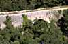 The bridge is about 6 km northwest of the village, actually in the commune of Tourtour. Take the N557 west from Flayosc and turn right just after the gas station (Route des Plans). After 1.5 km, turn right towards "Fontroussière". After 3 km the pavement ends. Park and walk (or drive) down the dirt road, the old Voie Romaine, to the bridge. The bridge is in very good condition, crossing a beautiful forested valley. We photographed the bridge by sitting on a tree jutting out over the gorge on one side, and by climbing a tree leaning out over the gorge on the other side. (Photo-6; Photo-7; The big photos are 30 k each; click on the thumbnails.)
Waterfall
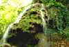 The "cascade" at Sauve-Clare, is about 2 km south of the village on a pretty country lane through the fields and forests. The cascade is small but very lovely, sitting behind a huge multi-centenarian plane tree next to the road. The water comes out over very mossy stones that have built up from deposits over thousands of years. The cave at the top, beside the falls, goes back into the rocks and seems to have been smoothed out inside by human effort. The ruins of a huge old mill are around the bend above the cascade. (Photo-8: The big photo is 30 k; click on the thumbnail.)
- Dates, Numbers
- Market day: Sunday
- Foire:2nd Monday March; 10 Aug; 1st Monday May and Oct.
- Office de Tourisme - tel: (33) 494 70 41 31; fax: (33) 494 70 47 91
- Mairie - tel: (33) 494 70 40 03; fax: (33) 494 70 40 63
- Club Joie de Vivre - tel: (33) 494 70 36 82
Camping (Draguignan)
- Hiking
- Maps:
- IGN "bleue" (1:25,000) 3444 est "Draguignan"
- Didier Richard (1:50,000) #25 "Maures, Haut-Pays Varois"
-
Hiking trails just south of the village, between Flayosc and Lorgues, allow some loop hikes in the wooded hills around Le Peyrega and Les Lunettes, and past the hamlet of Sauve-Clare with its waterfall.
The nearest trails to the north are in the mountains between Tourtour, Ampus and Chàteaudouble, about 10 km away.
To the southwest, there are a number of hiking trails in the hills between Lorgues and Salernes.