 Châteaudouble
Provence-Beyond (Beyond the French Riviera) ®
Var (83300)
Population: 322
Altitude: 525 m
Nearby:
[ Ampus | Draguignan | Figanières | Montferrat ]
Photos:
The ancient tower above the village
A view of the village from the tower hill
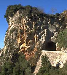
A larger photo of the entrance tunnel
 You can get to Châteaudouble on the small D51 road from Ampus (8 km to the west).
Coming from the other side, you turn off the D955 Draguignan-Comps road and take the D51 up to the village; here you pass through a tunnel through the rock that seems like it should be defended even today by bowmen to protect the village perched on the cliffs just above.
You can get to Châteaudouble on the small D51 road from Ampus (8 km to the west).
Coming from the other side, you turn off the D955 Draguignan-Comps road and take the D51 up to the village; here you pass through a tunnel through the rock that seems like it should be defended even today by bowmen to protect the village perched on the cliffs just above.
Châteaudouble is located on a redoubtable rocky spur overlooking a series of fantastic gorges and valleys cutting through the thickly forested hills. The Gorges de la Nartuby and the Gorges de Châteaudouble are formed by the Nartuby and Ampus rivers from the northeast and northwest that join together just south of Châteaudouble. The village clings to the rocky cliffs, with a pair of towers above: one in ruins but the other still standing lookout. The cemetery is also at the top, with an eagle's view the the surrounding hills and valleys. Above the village at the peak on the other side is a playground in the trees and a small football pitch with wooden goals, in a field that overlooks the world. This would be a great place for looking at the stars at night.
The village houses, shops and restaurants clustered so tightly together are bright and clean and well cared for. A beautiful old church in the center of the village has doorway arches made from a natural, stratified rock that contrasts well with the iron-studded wooden door. One village speciality is the local honey.
History
First record, 1021: Castellum Diaboli; and in 1038: Castel Duplo
Medieval:
In 1439, Châteaudouble was the joint domain of Arnaud de Villeneuve and Bertrand d'Esparron.
Louis de Villeneuve fortified the village.
The superb defensive position wasn't enough for the Wars of Religion:
the protestants from Draguignan took refuge in the village, and the fortifications were
then destroyed as they were dislodged by those of the opposing faith.
Dates, Numbers
Fête: first Sunday after 24 June; mid Aug
Mairie - tel: (33) 494 70 90 02; fax: (33) 494 70 93 11
Hiking
Maps: IGN 3443 est "ampus" (1:25,000); Didier Richard #25 (1:50,000).
There are many small trails above the village, to the north and northwest, where the peaks go to between 600 and 900 m.
About 3 km due north is the east-west boundary of a very active military camp, where tank and cannon exercises take place regularly.
Due south of Châteaudouble are two areas with a number of hiking trails with short loops. The first area is on the high plains (600 m) between Châteaudouble and Rebouillon. From Châteaudouble, take the road down to the bridge over the Nartuby river (410 m) and then follow the trail up to Château de la Garde (560 m).
One of the trails from Château de la Garde passes by the Colle Pelade (656 m) and drops down to the Vallon de la Cassade to the south. From the valley, the trail goes up to Le Malmont hills and forest to the south, where there are some nice trails just above Draguignan.