 Fayence
Provence-Beyond (Beyond the French Riviera) ®
Var (83440)
Population: 3500
Altitude: 325 m
Nearby:
[ Bagnols-en-Forêt | Bargemon | Cannes 39 km (0h40) | Lac de St. Cassien | Mons | St. Paul-en-Forêt | Seillans ]
Photos:
Marketplace vegetable vendor
Below: [ History | Dates-Numbers | Flying | Hiking | Lodging ]
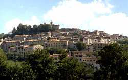 If you travel along the D562 between Draguignan and Grasse, you'll see Fayence perched on a hill top to the north, surveying the plains to the south. Fayence was a fortified town and, in spite of its size, it has kept the charm of its medieval origins. This is a center for tourists and visitors, with plenty of hotels, garages, and shops. In the spirit of Beyond, you can consider it a gateway to the more isolated interior.
North of Fayence, the D563 road goes through oak-forested hills to Mons, and beyond to the Route Napoléon. As you get closer to Mons, you'll discover deep gorges cutting through the hills, with rocky cliff faces showing here and there through the green vegetation.
Name
First record, 909: Fagentia; 1119: Favenze
In Latin, Faventia Loca means a favorable location.
History
Roman: Vestiges of Roman occupation were found at Notre-Dame-des-Cyprès (1 km west), at La Bégude (20 km southwest) and at the Moulin de Camandoule.
Medieval: The Saracen invasions devastated Fayence, leaving the town deserted, although the Monks of Lérins had an important convent here (at the Notre-Dame-des-Cyprès) from the 11th century on. In the 12th century, Alphonse 1st d'Aragon gave the fief of Fayence to the bishops of Fréjus. In the 1391, Turenne destroyed the village of Callian, 5 km to the east, and the fleeing people came to Fayence, repopulated it for the first time since the Saracens had passed through. In the 18th century, Monsignor de Fleury decided the château of Fayence was too expensive and useless, and had it destroyed.
- Dates, Numbers
- Office de Tourisme - tel: (33) 494 76 20 08; fax: (33) 494 76 18 05
- Market day: Tue, Thur, Sat
- Foire à la Brocante: beginning Aug
- Foire: mid Aug
- Fête: end June; 13-14 July
- Fête: 8 Sept (4 days)
Flying
The airfield on the plain just south of the town is a major sailplane (gliders) center. Founded in 1935, the gliding club is considered the best in Europe, and you'll see sailplanes here from across France and other European countries. The 1995 world championships were held here in September.
- Hiking
- Maps:
- IGN "bleue" (1:25,000) 3543 est "Fayence"
- Didier Richard (1:50,000) #25 "Maures, Haut-Pays Varois". Fayence is in the northeast corner of this map, so you might also need #19 (Haute Provence Verdon) for the north and northwest, or #26 (Pays d'Azur) for the east.
- Michelin "green" #114 (1/100,000) - "French Riviera - Var"
-
Trails directly around Fayence mostly follow the small roads, since the area is pretty well built-up.
 One of these local trails leads about 5-6 km to the south-southwest into the Maures, where it connects with several good trails, including the GR 51 (Balcony of the Cote d'Azur).
About 6-8 km to the southeast, some trails go through the hills to the Lac de St. Cassien. This area is "forested", but the brush is thick and the trees are low, and it can be extremely hot and dry during the summer.
To the north-northeast, a trail runs through the Forêt de Tourrettes, partially following roads, to join the GR 49 (Grande Randonnée) that runs up through Mons.
One of these local trails leads about 5-6 km to the south-southwest into the Maures, where it connects with several good trails, including the GR 51 (Balcony of the Cote d'Azur).
About 6-8 km to the southeast, some trails go through the hills to the Lac de St. Cassien. This area is "forested", but the brush is thick and the trees are low, and it can be extremely hot and dry during the summer.
To the north-northeast, a trail runs through the Forêt de Tourrettes, partially following roads, to join the GR 49 (Grande Randonnée) that runs up through Mons.