 Le Bar-sur-Loup
The City of Orange Trees
Provence-Beyond (Beyond the French Riviera) ®
Alpes-Maritimes (06620)
Population: 2650
Altitude: 320 m
Nearby:
[ Caussols | Cipières | Gourdon | Grasse | Gorges du Loup | Nice ]
Photos:
[ The village and the chàteau (20 k) ]
[ The statue of the admiral, hero of the American Revoluton (20 k) ]
[ The old railway viaduct at the edge of the village (32 k) ]
[ An aerial view of the village, on a hazy winter day (29 k) ]
[ A paraglider by the "baou" above the village (20 k) ]
Below: [ History | Dates | Admiral de Grasse | Commerce | Transportation | Hiking | Lodging ]
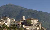 Le Bar-sur-Loup is perched on a rocky spur extending out from the Sarrée plateau overlooking the Loup river valley. The old village is lovingly restored, with the old houses clustered around the 13th-century chàteau and church in the center. The circular layout of the village is more or less maintained, with large sections of the original ramparts still visible from rue Estrabarry and rue Cheiron.
The narrow village streets below the chàteau are still very medieval, with many covered passages ("abris") where houses now fill the space above the streets. On Rue du Pin d'Aval, troglodyte dwellings still exist beneath the large rocks. On Rue Pierre de l'Encan, a low stone ("pierre") has four small holes that once held candles, which were the timers for local auctions ("encan"). There's a pretty little "place" just below the chàteau, on Rue du Docteur A. Maurel, with a cayenne pepper tree that was brought to the village by the Admiral de Grasse.
The view from the village is excellent, out over the Loup valley and up to Gourdon over the Gorges du Loup. A hike up to the Sarrée plateau gives an even better view of the countryside, and down onto the village.
The very active Office de Tourisme is housed in the imposing square tower in the very center, at the Place de la Tour and the Place Francis Paulet. "La Tour" was the keep of the old manor castle. Knocked down in 1792 during the Revolution, the square stone base is still pretty impressive.
The Château (which is privately owned and cannot be visited) was probably built from the 10th-13th centuries. The present construction is from the 14th-16th centuries, although it was pillaged and partially burned in 1792.
The 15th-century gothic church, St. Jacques-le-Majeur, contains the "Danse Macabre", one of the oldest paintings of the region. Painted on wood in the 15th century, it depicts an event from the Lenten ball given in the castle by the Count of Bar, and includes text in 15th-century Provencal verse. During the ball (as the story goes), the floor collapsed and caused the death and injury of several dancers. The unknown artist shows the Count playing a Provencal flute (galoubet) and drum (tambourin) while the guests dance, and Death arrives with his bow and arrows to inflict death and injuries on the dancers.
Name
First record, 1078: Albarnum or Poncii Albarni. In 1235, the village was named Catrum de Albarno, or "fortification on a height", when rule passed from the Princes of Antibes to the Count of Provence. In the 16th century, it took the Provencal name Lou Barn, which became Le Bar. The inhabitants, however, still call themselves Leïi Aubarenc in the local dialect.
History
Prehistoric:
A neolithic grotto is located on the edge of the Sarrée plateau, in the cliffs near Pilon. The oppidum of La Sarrée, on the plateau above the village, still has an enormous wall several hundred meters long protecting the ridge.
Celtic-Ligurian: The Celts, the Gauls and the Ligurians (750 BC) were all here.
Roman: The Romans were here in 125 BC, and two tombs where located where the Château now stands. One of the engraved tombstones is built into the base of the church bell tower, on the side next to the château.
Medieval: Bar-sur-Loup was ruled by the Counts of Grasse-Bar from 1218 until the Revolution.
- Dates, Numbers
- Office de Tourisme - Tel: (33) 493 42 72 21; Fax: (33) 493 42 92 60
- Fête de la St-Jean: Sunday closest to 24 June
- Fête de Patrimoine: Easter Monday; includes a fête artisanale and the annual orange-wine contest
Admiral de Grasse
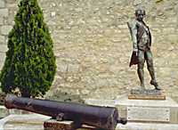 "Amiral de Grasse", François Joseph de Grasse, born in the Chàteau in 1722, was the most famous of the ruling Counts. As a Lieutenant-General in King Louis XVI's Royal Navy, he led the victory of Yorktown on Chesapeake bay, to the enormous benefit of the Independence of the United States of America. Admiral de Grasse, like La Fayette and Rochambeau, came to the aid of America and became a true hero of the American Revolution. Like John Paul Jones, who was ignored in America but honored in France after the war, Amiral de Grasse was honored in America but forgotten in France.
Commerce and Lodging
"L'Amiral" has a terrace cafés, and there's a bar-restaurant and a tiny Café-Bar-Tabac. The old village also has "épiceries", a boucherie-charcuterie and a pharmacie. There's a pottery shop at one end of the village, and the Office de Tourisme sells local products, including pottery, wine, honey and "herbes de Provence". There are more restaurants along the D2210 road just below the old village.
A candy factory, specializing in the local candied fruits, is located at Pont du Loup, 2 km down the road at the mouth of the Gorges du Loup.
Transportation
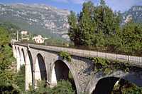 Regular bus service, several times a day, links Le Bar with Grasse to the west, and Tourrettes-sur-Loup, Vence, St. Jeannet and Gattières to the east. Grasse has regular bus service to Nice and Cannes. Sadly, the old railway line through the hills is long out of service. This lovely viaduct is one of many damaged in the last war.
- Walking Tour
- A walking tour of the village starts at the Office de Tourisme, guided by an excellent brochure (in French, English or German).
- Hiking
- Maps:
- IGN (1:25,000) 3643 ET "Cannes, Grasse"
- Didier Richard (1:50,000) #26 "Pays d'Azur"
- The GR 51 (Balcony of the Cote d'Azur) runs along the ridge just above Bar-sur-Loup. Local hikes from the village connect to the GR 9 trail, to Gourdon, and to other hikes across the high plateaux above the village.
- Three local hikes are marked by red, white and blue painted arrows in front of the Office de Tourisme. The hikes along the hillside above the village have fantastic views of the countryside and the Mediterranean as far as Cannes and the Iles de Lerin. The White hike makes a short loop of 1h30. The Blue hike makes a longer loop of 2h30. The red hike goes up to Gourdon (1h40), where you can return by the same trail, or by looping back across the plateau through the Bois de Gourdon.
 All three hikes leave the center via Ave de Yorktown. After 2-3 minutes, turn left onto the Chemin de Bessuranne and out past the cemetery to the Chapelle St. Claude [0h5+]. Turn left, then immediately branch left onto the path that goes up the hillside for 15 minutes to the junction with the traversing trail [0h20].
- White trail. The white trail turns left, pas the base of the cliffs, and goes up an easy incline to the aqueduct that provides drinking water to Cannes. This trail eventually joins the road that returns to the village.
- Blue, Red trails. From the first junction, the blue (and red) trail goes to the right, along a level trail through a lovely forest (actually following an underground aqueduct). The trail goes through a small tunnel and across a metal "passerelle" [0h35], and arrives at the Chemin du Paradis [0h45]. Turn left and go up the steps of an old mule trail to join the GR 51 and a fountain with cool drinking water [1h; balise #101].
- The Red trail continues from the fountain along the Chemin du Paradis, going up rather steeply but aided by steps, to Gourdon.
- The Blue trail continues to the left from the fountain, following the canal providing drinking water to Grasse. The canal is in a surface pipe, over the top of the old cement underground aqueduct. This is also part of the GR 9 trail, with its red and white marks. The pipeline and trail pass through several tunnels; none are completely dark, but a flashlight will help. The trail comes in view of the village about an hour along the canal [2h]. When the GR turns right up the hill to detour the private property [2h15], turn left down the little dirt road through the woods. There's a quick right turn at a chain marking a private property; the path continues down the hill another 10 minutes to join the "white" trail at a paved road, and goes on into the village.
- Paragliding
- Azur Vol Libre
- 372 chemin du Bosquet; 06620 Le Bar-sur-Loup
- Tel: (33) 493 09 44 54; Fax: (33) 493 09 44 54
- Lodging
- La Thebaide
- tel: (33) 493 42 41 19
- Chemin de la Sentoline; 06620 Bar-sur-Loup
- V.V.F Grasse
- tel: (33) 493 70 45 39
- Chemin de la Clavary; 06130 Grasse