 Tourrettes-sur-Loup
Provence-Beyond (Beyond the French Riviera) ®
Alpes-Maritimes (06140)
Population: 3449
Altitude: 400 m
Nearby:
[ Gourdon | Grasse 20 km | St. Jeannet | St. Paul | Vence ]
Photos:
1 Tourrettes perched on the cliff edge, from the east (20 k)
2 The "Grand Rue" through the village (30 k)
3 The fountain in the courtyard of the "Mairie" (28 k)
4 Inside the old château, now the "Mairie" (16 k)
Below: [ Gastronomy | History | Dates | Hiking | Lodging ]
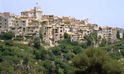 Tourrettes is a beautiful medieval village perched on a narrow spur of land extending from very rocky hills, with the gorge of a small stream deep below one high wall of buildings. Tourrettes was a fortified village, and the arched passages remain through the wall of houses in three places into the center of the "vieux village".
The village is backed by a range of hills, from the Puy de Tourrette (1268 m) to the hills around the Col de Vence. Two km west of the village, past the Pic de Courmettes (1248 m), the Loup river cuts through the deep Gorges du Loup at the foot of Gourdon Bar-sur-Loup. The Loup passes along the edge of the commune, a couple of km south of the village carrying its name.
Parking in the center is pretty difficult, so if you're driving in from Vence it might be worth parking in the free lot just at the edge of the village. There's also a pleasant little park out there, with a shady picnic area and a teeter-totter for the wee ones. When you're ready to walk up to the center, take the little street that runs down below and to the left of the main road. There's a nice view of the deep valley below the village, and you'll pass through the aqueduct at the old mill.
The main "Place" in the center is a parking lot; not so pretty, but there's not much choice in this rocky country. The "pétanque" court is at the end of the parking lot next to the road, and just across the road is the stone "lavoir" and "bouvoir" (the old drinking troughs and laundry basin).
Gastronomy
A speciality of Tourrettes is the tarte à l'orange.
You can find it at "La Tourrettoise" boulangerie-patisserie at the back side of the central parking.
Then take the tart back across the road to the "Chez Gabby" (actually the Café du Midi) for your coffee break. If you're there for breakfast, Chez Gabby does ham-and-eggs, although it's not listed anywhere.
Walking Through the Village. At the back of the parking lot, the "Grand Rue" loops through the vieux village, with one entrance through the arched porte at the left, and the other entrance at the right, through the arched porte beneath the tall clock-bell tower.
The Grand Rue (photo, 30k) passes through most of the vieux village.
Beside #48 on the Grand Rue, a side street goes out through the arched passage of the Portail Neuf, and descends along a stone-paved path down the rocky spine below the village.
It's a nice walk and a nice view, of forested hills to the sea, the old railway viaduct (and the remains of a broken viaduct), and looking back up towards the village, of the deep river gorge of the Cassan.
Name
First record, 1024: Castrum de Torretis
16th century to the Revolution: Tourrettes-lès-Vence
In 1982, a bureaucratic error somewhere lost an "s", making the official name Tourrette-sur-Loup, but the villagers and the municipality voted to ignore the "official" and retain the "real" name.
History
Prehistoric: A paleolithic shelter is located a the Pie-Lombard, on the cliffs above the Loup river 2 km to the southwest.
Celtic-Ligurian: A very large celtic-ligurian camp, below the old railway viaduct southeast of the village, has the vestiges of several rooms, huge walls, sculpted rock and several bories.
Roman: Pre-Roman oppidum are located on the Pic de Courmettes (1248 m), 3 km northwest, and the Puy de Tourrette.
In the church is a 1st-century altar dedicated to Mercury.
Medieval: In 1387 the fief of Tourrettes was put under the feudal control of Guichard Villeneuve (called the Bastard of Vence).The commune remained part of the Seigneurie des Villeneuve from the 14th century to 1789.
- Dates, Numbers
- Fête patronale: Sunday closest to Ste-Madeleine
- Fête de Violettes: 2nd or 3rd Sunday in March, with floats
- Office de Tourisme
- 2, route de Vence, 06140
- tel: (33) 493 24 18 93; fax: (33) 493 59 24 40
- Open: Mon-Sat, 09:30-12:30, 14:30-18:30
- Hiking
- Maps:
- Michelin "green" #115 (1/100,000) - "French Riviera - Alpes-Maritimes"
- IGN (1:25,000) 3643 ET "Cannes-Grasse"
- Didier Richard (1:50,000) #26 "Pays d'Azur"
-
 A trail to the south of the village goes down to the Loup river west of La-Colle-sur-Loup. Leave the village through the arched passage of the Portail Neuf beside #48 Grand Rue. Go down the spine to the small road at the end of the viaduct. Follow the road southeast, through "Plan Bouisson", into the forest to the south.
Another trail goes northeast from the village to join the GR51 (Balcony of the Cote d'Azur) on the hills south of the Col de Vence. Take the main road east from the village, through the parking lot at the bend in the road (300 m), and follow the small road up past La Madeleine.
Past the end of the road, the trail goes easily up through the woods until it crosses the Gue du Malvan (ford) and leads to the Chapelle St.Raphaël, sitting on a high rock in the woods, on a prehistoric site. A bit further on are the ruins of the Chàteau de la Reine Jeanne, with the junction of the GR51 beyond that.
Another very nice hike, although not a loop, goes west from the village, through the hills, past the Domaine de Courmettes, then north to join the GR51 near the tiny village of Courmes. A branch of the GR51 goes north and east to St. Barnabé and the Col de Vence.
A trail to the south of the village goes down to the Loup river west of La-Colle-sur-Loup. Leave the village through the arched passage of the Portail Neuf beside #48 Grand Rue. Go down the spine to the small road at the end of the viaduct. Follow the road southeast, through "Plan Bouisson", into the forest to the south.
Another trail goes northeast from the village to join the GR51 (Balcony of the Cote d'Azur) on the hills south of the Col de Vence. Take the main road east from the village, through the parking lot at the bend in the road (300 m), and follow the small road up past La Madeleine.
Past the end of the road, the trail goes easily up through the woods until it crosses the Gue du Malvan (ford) and leads to the Chapelle St.Raphaël, sitting on a high rock in the woods, on a prehistoric site. A bit further on are the ruins of the Chàteau de la Reine Jeanne, with the junction of the GR51 beyond that.
Another very nice hike, although not a loop, goes west from the village, through the hills, past the Domaine de Courmettes, then north to join the GR51 near the tiny village of Courmes. A branch of the GR51 goes north and east to St. Barnabé and the Col de Vence.