A safer way to run a forest fire...
is to model it on a computer. But first, let's look at how a computer can map the day-by-day danger of fire.
Wildland Fire Assessment System (WFAS)
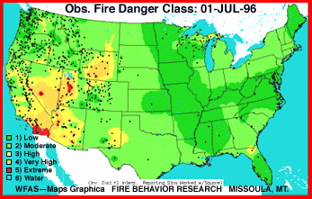
The U.S. Forest Service's Intermountain Fire Sciences Laboratory in Missoula Mont., developed this system to calculate and distribute fire danger information. The data comes from daily weather reports from more than 1,000 fire danger weather stations nationwide.
 The Wildland Fire Assessment System predicts fire risk by generating fire danger maps. A Fire Danger Rating determination reflects the National Fire Danger Rating System (NFDRS), taking into account current and previous weather, fuel types, and the state of both live and dead fuel moisture.
To see today's map, press the "Fire Danger Class" button on this link.
FARSITE
No, that's not the spelling of a wanna-be ophthalmologist. That's geek-speak for Fire Area Simulator, a compu-creature also developed at the Intermountain Fire Sciences Laboratory. FARSITE is an on-scene computer model designed to help land managers decide whether -- and how -- to fight blazes.
The process begins by typing the coordinates of the fire into a PC, which generates a map showing the progress of the fire at various stages. From that information, managers can decide what areas are endangered. Given the increasing tendency to let some fires burn themselves out, the model should help land managers decide whether fight or flight is the best strategy.
For another view of FARSITE, see "Modeling Forest Fires" on the bibliography.
A red-hot computer model
A group of modelers at Oak Ridge National Laboratory has cooked up a model specifically for Yellowstone. Computer models run during the 1988 Yellowstone fires were "notoriously poor," says William Hargove, research associate at Oak Ridge National Laboratory. These models were based on the science of thermodynamics (defined), using information from wind-tunnel tests of burning dowels and wood scraps.
The problem was two-fold. First, although the models required "incredibly fine-scaled information about the fuel in the forests," nobody was available to measure the density, type, and age of trees in the path of the flames. Second, Hargrove says, information from burning dowels was being "extrapolated to wildfires over landscape scales." Thus, the models had great difficulty producing a credible picture.
With support from the National Science Foundation, Hargrove and his colleagues participated in developing EMBYR (Ecological Model for Burning in the Yellowstone Region), which uses probability to go from a certain set of starting conditions to the fire's situation a few days down the line.
Under the leadership of Bob Gardner (who's now at the Appalachian Environmental Lab, University of Maryland), the Oak Ridge researchers spent five summers examining the aftermath of the fires at Yellowstone. The software breaks the landscape into cells (defined) 50 meters square. Then it accepts inputs about wind direction and speed, fuel type and moisture level.
As the model runs, changeable parameters, like wind direction and speed, can be altered to show how fires change, for example, as the burning conditions become drier or windier.
The typical process is to run EMBYR many times, and electronically combine the output into a "risk map" for areas surrounding the fire, showing where it is likely to spread. Says Hargrove, "The objective is, in a number of model runs, to create results that describe a real-world fire."
You'll probably want to read about how they use probability to model fires.

There are
1
2
3
4
5
6
7
8
9
10
11 documents.
(Glossary | Bibliography)
 The Wildland Fire Assessment System predicts fire risk by generating fire danger maps. A Fire Danger Rating determination reflects the National Fire Danger Rating System (NFDRS), taking into account current and previous weather, fuel types, and the state of both live and dead fuel moisture.


