WhaleNet's Satellite Tagging Observation Program - STOP


WhaleNet will coordinate the Satellite Tagging Observation Program - STOP. The goal of this phase of the project is to enable students to participate with scientists in unique research using advanced technologies.

Students and educators can work in conjunction with international research organizations such as theMingan Island Cetacean Study in Longue Pointe de Mingan, Quebec; the New England Aquarium in Boston, Massachusetts; and Allied Whale at the College of the Atlantic in Bar Harbor, Maine, in a unique program using advanced satellite technology and telecommunications to monitor and research the actual migration patterns and movements of selected species of whales throughout the oceans of the world. Students and educators can access and use data and information from this program on a continuing basis through WhaleNet.

The Satellite Tagging Observation Program will be coordinated through WhaleNet and will work in collaboration primarily with Scott Kraus, Director of Research at the New England Aquarium, Boston, Massachusetts.

The tags will make it possible to track the whales electronically, thus enabling researchers to answer questions about whale movements and migrations that have never been resolved satisfactorily. For example, we will work with: Scott Kraus and the Pelagic Research Lab of the New England Aquarium to investigate the movements of rare North Atlantic Right Whales, Arctic Seals, and possibly Bowhead Whales; Richard Sears, Executive Director of the Mingan Island Cetacean Study, to find where Blue Whales and Fin Whales go in the winter in hopes of finding their calving grounds; and, Allied Whale of the College of the Atlantic to try to determine the migratory routes of the Humpback Whale to and from its calving grounds.

The answers to these questions are not known, and students will be able to participate in these innovative investigations from their classrooms via telecommunications.

Satellite Tagging Schedule

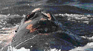
WhaleNet will make available information from as many as 12 satellites each year. Found in the satellite data are fixes of a Northern Right Whale named "Metompkin" that became entangled in fishing equipment off the coast of Georgia, two blue whales feeding in the Gulf of St. Lawrence, and a hooded seal, "Stephanie", on her migration to polar waters. The tagging data is made available on WhaleNet through a collaborative program with research groups, WhaleNet and the Pelagic Research Lab at the New England Aquarium.

As WhaleNet progesses we will have satellite tags on right whales, blue whales, humpback whales, fin whales, seals, and possibly bowhead whales. We plan to begin this spring with tags on arctic seals that will be released from the New England Aquarium. We hope that you will participate and check back on a regular basis.

- the WhaleMaster

Please Click Here For
All STOP Data, Maps and Observations

WhaleNet EnviroNet
click here click here
Home Page Home Page