WhaleNet
Blue Whale Data

Blue Whale


Notes
  • Gulf of St. Lawrence Information and map
  • Tagging Team Information
  • Satellite Tagging/Boston Globe Article, (This may be slow.)
    Backup to above article
  • Study Guide for use with Data
  • Blue Whale Contaminant Analysis

    Research Trip Data

    These data entries present the research track of the Mingan Island Cetacean Study (MICS) vessels in the Gulf of St. Lawrence estuary during the period of the satellite tagging operation.

  • August 18 Track
  • August 19 Track, "Kits" Tagged
  • August 20 Track, "B242" Tagged
  • August 21 Track
  • August 22 Track

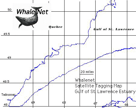
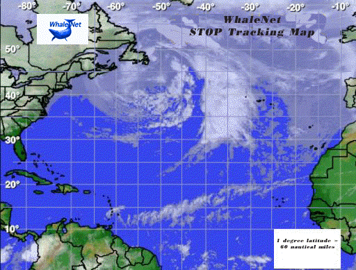
    Blue Whale Satellite Tagging Data

    These data entries list the fixes made by the satellite tag during their periods of operation.

  • "B242", Satellite Tag #92 Data
  • "Kits", Satellite Tag #94 Data

    Charts and Maps for Satellite Tagging Program

    You can download these maps and charts to observe the movements of the whales or to track the movements of the whales yourself.

  • "B242" Satellite Tag 92 Chart
  • "Kits" Satellite Tag 94 Chart
  • Blank Map for your use
  • No. Atlantic Map for your use
  • Gulf of St. Lawrence Map for your use

    "Kits" Sighting History

  • Kits History, Page 1
  • MICS Research Zones in Gulf of St. Lawrence, Canada


    WhaleNet EnviroNet
    click here click here
    Home Page Home Page