 Thorenc
Provence-Beyond (Beyond the French Riviera) ®
Alpes-Maritimes (06750)
Population: tiny (part of Commune of Andon)
Altitude: 1250 m
Nearby:
[ Plateau de Caussols | Andon ]
Photos:
A stone church in the village of Thorenc (24 k)
Below: [ Hiking | Lake ]
 Thorenc is a small village set in a thick forest of Scots pine,
and is fairly isolated from the main roads of the region.
It is about 35 km north of Grasse and about 30 km south of
Entrevaux or Puget-Théniers on the N202,
although it's not really accessible from the north.
Thorenc is a small village set in a thick forest of Scots pine,
and is fairly isolated from the main roads of the region.
It is about 35 km north of Grasse and about 30 km south of
Entrevaux or Puget-Théniers on the N202,
although it's not really accessible from the north.
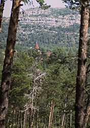
From Grasse, take the N85 (Route Napoléon) through St. Vallier (12 km), and turn right onto the D5. Follow this road 24 km, past the Col de la Sine (1080 m) and the Pont-du-Loup junction, until it ends at the T-junction with the D2. Turn left (east) and go 2 km. A tiny road turns off right (north), and winds through the pine forest to Thorenc. This photo shows a brief glimpse you get through a gap in the forest as you approach the village.
When you get there, you'll probably wander around the small roads connecting the isolated chalets until you find the center. Thorenc is a center for ski de fond and hiking. There are a few nice café-restaurants with outdoor terraces, all nicely shaded. There are a few other shops and some hotels.
The environment is forest, with the steep mountains rising up behind (north) to the Col de Bleine. Both strawberries and raspberries grow wild all around the Thorenc area. A large painted sign on the front of one chalet has a map of Thorenc, showing the different areas where the strawberries and raspberries are to be found. A raspberries festival is held annually (in July) in Thorenc.
Hiking
A billboard map beside the post office shows 14 local hikes, both long and short, that
you can take from Thorenc, into the Montagne de Bleine that rises to the north of the village.
Lac de Thorenc.
Down on the D2 road that passes east-west below the village,
is a the small Lac de Thorenc, with fishing, horseback and pony riding.
There's plenty of places for picnicking (although the whole region for kilometers
around is good for that), as well as a small café-restaurant and a small hut
where you can buy locally-made goat cheese and honey.