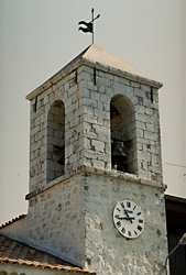
 Andon
Andon
Provence-Beyond (Beyond the French Riviera) ®
Alpes-Maritimes (06750)
Population: 300
Altitude: 1182 m
Nearby:
[ Plateau de Caussols | Thorenc ]
Andon is at the upper (west) end of the Loup river, about 30 km northwest of Grasse.
It's off the beaten track,
on the small D79 road about 5 km northeast of the Route Napoléon.
The village itself isn't particularly pretty; there's no center square with shade trees, and the café is on the road. There is a nice shop, however: the one store in the center (Chez Sylvie) has absolutely everything, like an old-fashioned general store.
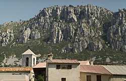
Andon is quiet though, and set in a high valley amidst hills and forests. The hills along the north side are forested, and they rise up as a long, rocky cliff. Outside the center village, there are several ski/vacation style chalets.
In June there is an annual Spring Festival with medieval combat in the style of the Knights of the Round Table, along with a variety of other games and entertainments.
Andon is located at the east end of a long, narrow plateau that's planted with grain. At the far end of this shallow valley is the tiny village of Caille. Ski de fond is popular here, with the high plains sheltered by the surrounding hills.