 St. Etienne-les-Orgues
Provence-Beyond (Beyond the French Riviera) ®
Alpes-de-Haute-Provence (04230)
Population: 1091
Altitude: 697 m
Nearby:
[ Banon 18 km | Forcalquier 17 | Lardiers 11 | Ongles 5 | Sigonce 12 | Sisteron 33 | Bories | Lure Montagne ]
Photos:
A church clock tower
Below: [ Hiking | Lodging ]
 St. Etienne-les-Orgues is located at the upper end of a wide valley that's bordered to the south and north by forested hills, and by the Lure mountains rising up behind the village.
Spread out below the village are grain fields and small woods, with a feeling of open spaces and calm.
Lavender fields are all around, out across the valleys and on the southern slopes of the Lure mountains, protected from the wind by forests of oak and larch.
St. Etienne-les-Orgues is in the southwestern corner of the Alpes-de-Haute-Provence, west of the Durance river, 17 km north of Forcalquier and 33 km southeast of Sisteron.
Driving up through the lovely valleys, the village isn't visible until you get there. The D951 road goes through the center of the village, passing by a large square, with outdoor cafés shaded by the wide-spread branches of large plane trees.
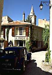
The real charm of the village is away from the main squares, in the narrow, hidden streets that wander between old churches and stone houses and past the forge.
Hiking
The Grande Randonnée GR6 trail passes through St. Etienne, roughly north-south.
To the south, the trail goes to Forcalquier, about 10 km away.
To the north, the GR6 goes up through the Forêt Domaniale de Lure,
to the Sommet de Lure at 1826 m, a good 1100 m of vertical climb for about a 10 km hike.
It's a beautiful hike, though, with magnificent views back to the south. The trail passes by
the Oratoire St. Joseph and Nôtre Dame de Lure at 1236 m, and the Refuge de Lure at 1572 m.
A trail goes west from St. Etienne, crossing the southern edge of the Lure, to Lardiers, about 7 or 8 km away. In this region, most trails run north-south, following valleys or ridges to the top of the Lure mountains, so a loop hike from St. Etienne-les-Orgues will take careful planning.