 Salignac
Provence-Beyond (Beyond the French Riviera) ®
Alpes-de-Haute-Provence (04290)
Population: 310
Altitude: 520 m
Nearby:
[ Volonne 7 km | Sisteron | Digne | Lac de l'Escale | Durance river | Route Napoléon ]
Photos:
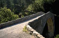
Another view of the Pont de la Reine Jeanne (36k)
 The hamlet of Salignac is listed here for the beautiful countryside surrounding it. The village of Sisteron is lovely, interesting, and extremely popular. In the middle of the summer, when the streets of Sisteron are jammed with tourists, head south out of town 3 km and turn east across the river. The road is marked for the autoroute, but don't worry about that. Across the river, take the small D4 road south towards Volonne.
Vilhosc
One km south, the little D217 turns off left towards Vilhosc and the Pont de la Reine Jeanne (pictured above). You'll immediately be passing through open corn fields and orchards, with the road winding across shallow valleys, and the low hills dotting the landscape are often capped with tiny chapels. The most action you'll see out here will be the hawks soaring over the fields.
At Vilhosc you'll find an 11th century Prieuré. A sign points down the little road to the farm, where you need to stop and ask for the key.
Another 5 km past Vilhosc, driving slowly and carefully on the narrow D17 road, will take you through pine forests and rocky crags down to the 14th century Pont de la Reine Jeanne. [Another view of the Pont de la Reine Jeanne (36k)]
Salignac
Instead of turning off towards Vilhosc, go 3 km south after crossing the river at Sisteron and turn off on the D604 towards Salignac. You can also get to Salignac from Vilhosc by wandering around the countryside on winding little lanes through the fields and hills. When you get there, you'll discover a lovely little village with the chapel St. Martin perched above it. Along with beauty, peace and solitude, Salignac has a café with tables on the terrace.
Hiking
Maps: IGN (1:25,000) 3340 est, 3340 ouest; Didier Richard (1:50,000) #28 "Montagne de Lure".
- A short (2 hour round-trip) hike from the bridge will take you up through the forest to the abandoned village of St-Symphorien and on to the peak at La Tour (841 m).
- Several different circular hikes are possible from the area of the Pont de la Reine Jeanne. From St-Symphorien, you can take a trail northwest and west to the top of the ridge (about 1350 m) about 5 km away. Head south along the ridge about 2 km to Les Vautes. Take the branch to the west, zig-zagging down the mountain through the trees. The trail heads northwest back to St-Symphorien and the bridge.
Riding trails will take you from Vilhosc out to the Pont de la Reine Jeanne. Riding stables are located just down the road in Vilhosc and in St. Geniez (on the D3, 16 km northeast of Sisteron).
- The trail to Sourribes goes east across the bridge and passes through St-Symphorien, about a km away. The trail then heads south another 5 or 6 km to Sourribes.
- The trail to St. Geniez (about 8 km) goes north along the small road from the west end of the bridge.