 Roquebrune-sur-Argens
Beyond the French Riviera®
Var (83520)
Population: 10390
Altitude: 13 m
Nearby:
[ Rocher de Roquebrune 1 km | Les Arcs 18 | Draguignan 21 | Fréjus 11 | Sainte Maxime 26 | Malpasset Dam (barrage) | Saint Tropez 40 | Gorges du Blavet 9 ]
Photos:
1 The village's chapel aux Penitents Blancs and the Rocher behind (29 k)
2 Part of the walled village and bell tower (39 k)
3 The porte and bell tower (36 k)
4 The 1789 fountain at the Chapel Saint Michel (27 k)
Below: [ History | Museums | Dates/Numbers | Hiking | Les Issambres | ]
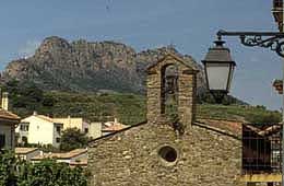 Roquebrune-sur-Argens, "Cité Millénaire", is an ancient town sitting amidst bunches of new villas that seem to grow so well in this climate. Looking beyond the newness, Roquebrune is located in an expansive pine forest, accentuated by the beautiful red cliffs of the Rocher de Roquebrune (photo, left) and cooled by the Argens river.
The ancient village was built on a rocky peak around the year 975, when the Saracens de Fraxinet were thrown out. Just about everything was destroyed in 1592 during the Wars of Religion; only one old tower remains today. From the village there's a panoramic view out across the Argens plain to the north, with low mountains in the distance.
Even with the modernization of the village (which is tastefully done), Roquebrune has retained a lot of charm. One entrance into the old part of the village is through an archway at the base of a 16th-century watch tower, with the campanile belfry at the top. Narrow old streets run between the old buildings and past the 16th century church. One building on the little square behind the church has a lovely sundial on the wall (up the stairs).
Name
First record, 1084: Roca Bruna (in an official paper of Pope Gregory VII).
History
Prehistoric: There are many signs of paleolithic and neolithic habitation in the region, including a menhir, a dolmen and Protohistoric walls.
Roman: Numerous Gallo-Roman traces can be found throughout the area, especially at the top of the Rocher. There's a sarcophage at the Col de Bougnon and a Gallo-Roman aquaduct, both near Les Issambres (below).
Medieval: Ruled successively by the vicomptes de Marseille, the bishop of Fréjus, the abbeys of Saint-Victor, Montmajour and Thoronet, and the order of Malta. According to Nostradamus, two sorceres were burnt here in 1428. During a siege in Feb 1592 by the Duke de La Valette, the Duke was killed, along with half the population, and many of the houses were destroyed.
From the 14th to 16th century, Roquebrune was a main wheat growing area. The rich river plain produced up to 10 times more than other areas.
- Dates, Numbers
- Marché Provençal: Tuesdays and Fridays
- Foire: 8 June
- Fête: 15 Aug
- Fête Provençale St Pons: 12 May
- Office de Tourisme - tel: (33) 494 45 72 70
- Hiking, Climbing
- Maps:
- IGN "bleue" (1:25,000) 3544 est "Le Muy"
- Didier Richard (1:50,000) #25 "Maures, Haut-Pays Varois"
-
Roquebrune-sur-Argens is on the northeastern edge of the Massif des Maures mountains, and there is plenty of good hiking. The GR 51 (Balcony of the Cote d'Azur) runs through the town. Much of the nearby hiking is through forests of low oak and high brush, without much shade to protect you during midday in the summer.
 South and southwest of town, the GR51 and other trails offer hiking in the nearby Maures. The GR51 goes southwest past La Garde-Freinet, and other connecting trails, including the GR9, go out to the coast at Ste Maxime and the Golfe de St Tropez.
6-hour Loop Hike. This loop starts at about 15 m altitude, goes up to 400 m (with only one short steep part), then gradually back down again. Take the GR51 goes southeast from town, then follow it south for about two hours. The GR51 turns northwest to the Col de Valdingard (400 m), at a junction on a paved road. Branch northwest off the main GR51, onto the GR51 variant, and follow it, curving north and then northwest back to town. The trail is generally on forestry roads, through low cork-oak forests and a mimosa forest. Small streams run along side the trail on a couple of different parts of the loop.
Northwest of town, the GR51 goes along the southern edge of the beautiful red rocks of the Rocher de Roquebrun, then crosses the autoroute at Le Muy and goes up into the forested hills around the Gorges de Blavet and Bagnols-en-Forêt.
South and southwest of town, the GR51 and other trails offer hiking in the nearby Maures. The GR51 goes southwest past La Garde-Freinet, and other connecting trails, including the GR9, go out to the coast at Ste Maxime and the Golfe de St Tropez.
6-hour Loop Hike. This loop starts at about 15 m altitude, goes up to 400 m (with only one short steep part), then gradually back down again. Take the GR51 goes southeast from town, then follow it south for about two hours. The GR51 turns northwest to the Col de Valdingard (400 m), at a junction on a paved road. Branch northwest off the main GR51, onto the GR51 variant, and follow it, curving north and then northwest back to town. The trail is generally on forestry roads, through low cork-oak forests and a mimosa forest. Small streams run along side the trail on a couple of different parts of the loop.
Northwest of town, the GR51 goes along the southern edge of the beautiful red rocks of the Rocher de Roquebrun, then crosses the autoroute at Le Muy and goes up into the forested hills around the Gorges de Blavet and Bagnols-en-Forêt.
- Museums
- Centre d'Exposition Archeologique, Prehistoire et Histoire de Roquebrune
- Chapelle Saint-Jacques (in the village)
- tel: (33) 494 45 34 28
- Hours 10-12:00; 14-18:00
- Open 1 June - 30 Sept: Tue-Sat
- Open 1 Oct - 31 May: Thur, Sat
Les Issambres
Les Issambres is a seaside residential community. It's located 17 km to the southeast, half way between Fréjus and Sainte Maxime, but belongs to the commune of Roquebrune.
Les Issambres was created in 1930. In 1944, the Americans landed here, on the beaches between Val-d'Esquières and Nartelle. In the Baie de Bougnon, between Les Issambres and Sainte Maxime, there's a Plage des Elephants, which makes us wonder about the origin of the name. Did Hannibal (from Carthage - Tunisia) land here?