 La Garde-Freinet
- "La Gardi"
La Garde-Freinet
- "La Gardi"
Provence-Beyond (Beyond the French Riviera) ®
Var (83680)
Population: 1,465
Altitude: 360 m
Nearby:
[ Brignoles 46 km | Collobrières | Fréjus 42 | Hyères 54 | Toulon 74 | St Tropez 20 | Ste Maxime 22 ]
Photos:
A bigger aerial view of the village (32 k)
An wider view of the village and the Maures to the east (24 k)
A stone house on a village street (26 k)
Inside the Confiturerie des Gambades shop (24 k)
Below: [ History | Dates | Transportation | Hiking | Lodging ]
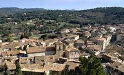 La Garde-Freinet is a medieval-style town sitting on a long narrow ledge of a pass, overlooked by high rocky peaks with the ruins of the ancient fort, the cross, and a great view out over the Maures in all directions. This is a pleasant town, with lots of shops, restaurants and such. There are narrow streets between the buildings, and several squares in different parts of town, but it isn't as picturesque as some of the smaller villages in Beyond.
The town has two distinctive halves. The older part of town is around the 16th-century St.Clément church, with an 18th-century campanile. This part of town has the narrow little streets, sometimes carved through solid rock. The "newer" part of town has wider streets and 19th-century houses.
The town sits beside the D558, one of the main roads between the A8 autoroute and the seaside resorts around St Tropez. It's a nice place to stop, and it's a good location for visiting the Maures, either by the twisty little roads or the hiking trails that go off through the forested hills.
The town is quiet from October to April, then in May the tourist traffic begins building up for the summer. The surrounding hills of the Massif des Maures, stretching out 30 km to the southwest and 20 km to the northeast, are forested with oak and cork oak. The area near the town has chestnut groves (châtaigneraies), and chestnut jam (confiture marron) and chestnut honey (miel châtaignier) are among the local products you can get at the Confiturerie des Gambades shop in town.
Name
First record, 13th century: Fraxinetum Guardia. Fraxinet was the name of the region and Le Freinet was the village. The original Provencal inhabitants called the village La Gardi. Fraxinet was a Saracen word, with Fraxinetum Guardia possibly meaning guard of the forest.
History
Prehistoric:
Chalcolithic sepultures were found at the Baume des Maures, in a cavern at the foot of the hill below the château.
Roman:
Gallo-Roman remains were found at La Mourre, and at St. Clément, 1 km southeast. A Roman road passed by the town.
Medieval:
The Saracens built the fortress here at the end of the 8th century, and used it as a base to ravage Provence for the next 200 years. In 973, Count William defeated the Saracens and took La Garde Freinet. In 1076 it became a fief of St-Fulcher. In the 14th century, the town was ravaged by the troops of Raymond de Turenne; it became part of the domain of the Pontevès, and was repopulated by Jean de Pontevè. The château was razed in 1589 by order of Maréchal de La Valette.
- Dates, Numbers
- Market days: Sun and Wed mornings, 6h-13h
- Fête: 5 Aug
- Foire: 16 June, 23 Nov
- Office de Tourisme
- Tel: (33) 494 43 67 41; Fax: (33) 494 43 08 69
- Open: 9h30-12h30, 14h-18h; closed Sun, Mon
- Transportation
- Two buses a day (except Sunday and holidays) connect La Garde-Freinet with Grimaud. At Grimaud, you change for the St Tropez, St Raphaël, Toulon bus. Toulon and Fréjus are on the mail rail line, that connects Beyond with Lyon and Paris to the north and Monaco and Italy to the east.
- Departure for Grimaud: 7h30 and 13h30 (contact the Office de Tourisme for the most current schedule).
- Hiking
- Maps:
- IGN "bleue" (1:25,000) 3445 est "Collobrières", (town and west)
- - 3545 ouest "St Tropez, Ste Maxime" (east of town)
- - 3445 OT "St Tropez, Ste Maxime, Massif des Maures" (includes coast south and east)
- Didier Richard (1:50,000) #25 "Maures, Haut-Pays Varois"
- Michelin "green" #114 (1/100,000) - "French Riviera - Var"
-
The GR 9 (Grande Randonnée) passes through La Garde-Freinet.
 To the east, the GR9 crosses the Maures and goes down to the coast to the trail's end, near Port Grimaud. In the Maures to the east of La Garde-Freinet, several other trails cross the GR9, including the GR51 Balcony of the Cote d'Azur.
Leaving town to the south, the GR9 turns west and goes through the forested Maures, past Les Mayons to Pignans and Carnoules. Branching trails, including the GR90, explore the southwestern part of the Maures.
To the east, the GR9 crosses the Maures and goes down to the coast to the trail's end, near Port Grimaud. In the Maures to the east of La Garde-Freinet, several other trails cross the GR9, including the GR51 Balcony of the Cote d'Azur.
Leaving town to the south, the GR9 turns west and goes through the forested Maures, past Les Mayons to Pignans and Carnoules. Branching trails, including the GR90, explore the southwestern part of the Maures.