 Orpierre
Provence-Beyond (Beyond the French Riviera) ®
Haute-Alpes (05)
Population: 335
Altitude: 698 m
Nearby:
[ Laragne-Montéglin 14 km | Serres 12 | Sisteron 30 ]
Photos:
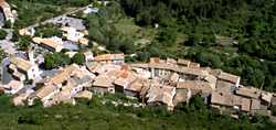
A larger view of the village, from above (25 k)
A narrow village street, where the GR passes (17 k)
The village church and the hills to the south (21 k)
The needle-like Suillet peak above the village (16 k)
Below: [ History | Dates-Numbers | Transportation | Cycling | Climbing | Hanggliding | Hiking | Lodging ]
 Rushing along the Route National with everybody else, turn off west at Eyguians between Serres and Laragne-Montéglin.
The little D30 road goes along the valley of Céans, with rich farmlands between two ranges of mountains with varied shapes. Only one minute from the rush, and you're in very beautiful countryside.
Rushing along the Route National with everybody else, turn off west at Eyguians between Serres and Laragne-Montéglin.
The little D30 road goes along the valley of Céans, with rich farmlands between two ranges of mountains with varied shapes. Only one minute from the rush, and you're in very beautiful countryside.
Only eight km down the road from Eyguians, the little Céans river cuts through a high mountain spine, in a narrow S-bend gorge at the base of high cliffs. The village of Orpierre is built into this narrow gap, and the vestiges of a defensive wall climb the steep northern spine to where the castle once stood.
There's a peaceful beauty here in this village, with the church, fountain and petanque courts, and a huge plane tree that was planted in 1780. High cliffs and steep mountains surround the village on all sides, but with in-between valleys for plenty of sun and light. A couple of terrace cafés provide stopping places for the hikers and climbers.
The heart of Orpierre is the circular, fortified old village (photo above). The streets are very narrow (photo 17k), and many of the houses seem to have the original medieval stone fronts. There's a maze of long, low vaulted passages beneath the houses from street to street; the most and the longest we've ever seen in Beyond.
South of the village, tall cliffs curve around into the gap of the Céans, and beside them the mountain slopes house a large campsite (photo 21k). Northeast of the village, the solitary peak of Le Suillet rises needle-sharp, with an interesting looking vertical cave high on the side (photo 16k). Northwest of the village is the rocky spine with the ancient wall.
Name
First record, 570-1100: Valperrus
History
Roman: There was a Roman presence here, and a treasure of Roman coins was discovered.
Medieval: The Barony of Orpierre belonged first to the Prince of Orange and then to the King of England. It was ceded to the King of France in 1713.
- Dates, Numbers
- Foire: 1 Apr, 1 June, 6 Aug, 15 Nov, 16 Dec.
- Fête patronale: 1st Sunday Aug.
- UCPA Orpierre: Tel: (33) 492 66 29 19; Fax: (33) 492 66 30 04
Transportation
Orpierre to Laragne-Montéglin is 14 km, and there's probably a bus. Laragne-Montéglin is on the rail line Aix-en-Provence, Sisteron, Serres,
Veynes-Devoluy. The Laragne-Montéglin Office de Tourisme is, Tel: (33) 492 65 09 38.
Cycling
VTT rentals are available from Vertige Sport in the village.
Climbing
![]() The eastern face of the rocky spine north of Orpierre is a wide wall of cliffs, called the "Mur d'Escalade" (climbing wall).
The eastern face of the rocky spine north of Orpierre is a wide wall of cliffs, called the "Mur d'Escalade" (climbing wall).
![]() Another climbing rock, at the Col de St. Ange on the Montagne de Chabre south of the village, as normally accessed via the village of Barret-le-Bas.
Another climbing rock, at the Col de St. Ange on the Montagne de Chabre south of the village, as normally accessed via the village of Barret-le-Bas.
- Vertige Sport, a small climbing shop in the village, serves the visiting rock climbers.
- Open daily, 18h-20h.
Hang Gliding - Paragliding Hanggliding and paragliding is done from the ridge of the Montagne de Chabre (1279 m), east of the Col de St. Ange.
- Hiking
- Maps:
- IGN (1:25,000) 3239E "Seyne"
- Didier Richard (1:50,000) #28 "Montagne de Lure"
-
The GR946 (Grande Randonnée) runs north-south through Orpierre.
 The GR north goes through the old village streets, beneath the vaulted passages, and up the narrow rock spine above the village.
Arriving at the top of a very narrow spine overlooking the village, there's a tremendous view east and west.
The GR goes up the western side, below the ridge, to Le Suillet (1324 m), marked as 2h30. The trail continues north through the mountains, then drops down to the village of Trescléoux (665 m), 4 hours from Orpierre.
For the GR south, go out east of the village and take the road south down to the river. The GR946 follows the little road, then continues up the side of the Montagne de Chabre to the Col de St. Ange (the site of climbing rocks). The trail drops down the southern slopes through the Méouge forest to Barret-le-Bas and points south.
The GR north goes through the old village streets, beneath the vaulted passages, and up the narrow rock spine above the village.
Arriving at the top of a very narrow spine overlooking the village, there's a tremendous view east and west.
The GR goes up the western side, below the ridge, to Le Suillet (1324 m), marked as 2h30. The trail continues north through the mountains, then drops down to the village of Trescléoux (665 m), 4 hours from Orpierre.
For the GR south, go out east of the village and take the road south down to the river. The GR946 follows the little road, then continues up the side of the Montagne de Chabre to the Col de St. Ange (the site of climbing rocks). The trail drops down the southern slopes through the Méouge forest to Barret-le-Bas and points south.