 Bédoin
Provence-Beyond (Beyond the French Riviera) ®
Vaucluse (84)
Population: 2215
Altitude: 300 m
Nearby:
[ Carpentras 15 km | le Barroux | Caromb | Mazan | Malaucène | St. Pierre/Vassols | Mont Ventoux | Villes-sur-Auzon ]
Photos:
A view of the village and Spring plowing the vineyards (23k)
The old church, from the rock walls above the village (16k)
Below: [ History | Camping-Nudism | Hiking ]
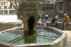 The village center is along the road at the base of the old village. Here you'll find a collection of terrace cafés under the shade of large plane trees. A small square just off the road, with a lovely old fountain, seems to be a favorite meeting place for some of the local inhabitants (photo).
The first thing you'll notice while approaching Bédoin is the huge, imposing church of Saint-Antonin, with it's Spanish-looking style so different from any other in the Provence region. In fact, the style is Jesuit, built in 1702 and restored in the 19th century In spite of the strangely different style, the church does have a wrought-iron belfry (campanile) so typical of the region.
The houses of this compact, old village look small compared to the church, and are clustered up against the hill. At the top of the village hill, above houses and church alike, the tombstones from an abandoned and vandalized graveyard are scattered about in the tall grass.
The ruined graves evoke a bit of sadness that tempers the incredible view from this high spot. The hilltop village of Crillon-le-Brave is visible across the fields to the southwest, while the 1900m-high Mont Ventoux towers high above Bédoin to the northeast.
Bédoin-Malaucène Road
The twisty little D19 road from Bédoin to Malaucène goes through the forest on the southwestern slopes of Mont Ventoux. Along part of this beautiful drive there's a belvedere said to have the most fantastic view of the whole Mediterranean (it's been a bit too hazy the few times we've stopped there). One of the fine sights from here is of the ocre quarries down below, with the different shades of the red earth exposed.
Llamas? That's right, llamas. And you've got to be careful, because doing a double-take on this narrow, twisty road could cause harm. Along the D19 in the forest of the Mont Ventoux, llamas are being raised. Part of the forested grazing land comes out along the side of the road, and often causes a moment's confusion to passing motorists.
Name
First record, 998: Beduinum
History
Prehistoric: Bédoin has been occupied throughout history, and there are remains of neolithic habitation.
Roman: There was a major Roman presence here, at the hamlet of St-Estève, of which some remains can still be seen in the region.
Medieval: Bédoin was ruled in turn by the Baux family (see also Baux-de-Provence), the Budos, the Peyre, the Orléans-Lamotte and the Vervins (into the 17th century).
- Dates, Numbers
- Fête patronale: 15 Aug
- Office de Tourisme - tel: (33) 490 65 63 95; fax: (33) 490 12 81 55
Wine
Apt is in the region of the Rhône Valley Côtes de Ventoux wines.
- Camping - Nudism
- The Domaine Naturiste Bélézy is a nudist camp with 4-star camping and caravaning and a Centre d'Hydrothérapie (water treatment). They have a recreation park, and also rent out individual houses.
- Hiking
- Maps:
- IGN "bleue" (1:25,000) 3140 est "Mont Ventoux"
- Didier Richard (1:50,000) #27 "Ventoux"
-
 The GR91B (Grande Randonnée) and a couple of well-marked local trails go north or east from the village, all connecting with the GR91 that runs west-southeast along the base of the Ventoux mountains.
To the north, a myriad of trails branch from the GR91 to climb the forested slopes of Mont Ventoux, some eventually getting to the peak at 1910 m.
To the northwest, the GR91 joins the GR4 just before it arrives at the village of Malaucène.
To the east, the GR91 circles down to the south, along the edge of the mountainous forests, to Villes-sur-Auzon and the Gorges de la Nesque.
The GR91B (Grande Randonnée) and a couple of well-marked local trails go north or east from the village, all connecting with the GR91 that runs west-southeast along the base of the Ventoux mountains.
To the north, a myriad of trails branch from the GR91 to climb the forested slopes of Mont Ventoux, some eventually getting to the peak at 1910 m.
To the northwest, the GR91 joins the GR4 just before it arrives at the village of Malaucène.
To the east, the GR91 circles down to the south, along the edge of the mountainous forests, to Villes-sur-Auzon and the Gorges de la Nesque.