Conceptual
Cross-Section (Regional Scale)
Conceptual
Cross-Section (Regional Scale) |
|
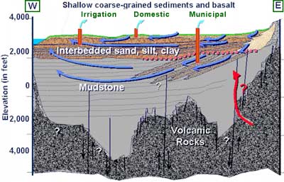
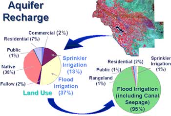
Shallow aquifers, present throughout the central portion of the Treasure Valley are often contained in the Snake River Group sediments. Depths of these aquifers are generally less than 250 feet below ground surface. Ground water in shallow aquifers generally originates at ground surface, in the form of precipitation, infiltration from irrigated areas, or infiltration from river and stream channels or canals (see “Aquifer Recharge”). Shallow aquifers can contain very localized flow systems such as from an irrigated field to the nearest drainage ditch, or extend tens of miles.
A deeper, regional aquifer system underlies shallower aquifers. The regional system extends throughout the valley, with ground water flowing in a generally westerly direction. Water enters the regional system at the basin margins or in the easternmost portions of the valley. Some of the tilted sedimentary zones underlying the geologic unconformity represent productive aquifer zones. Coarse-grained sediments overlying the unconformity may act as a manifold distributing water from the east Boise and/or peripheral areas into the underlying aquifer zones.
Estimated
Recharge to Shallow Aquifers |
 |
Aquifer
Water Balance |
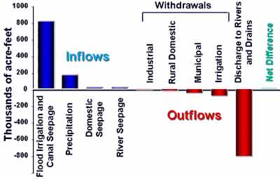 |
Infiltration from flood irrigation and canal seepage far exceeds recharge from precipitation or other sources (see “Water balance”). Ground water withdrawals for industrial, rural domestic, municipal, and irrigation uses are much less than the water that returns to ground surface as natural discharge. However, much of the withdrawals occur from deeper aquifer zones, while much of the discharge occurs from shallow aquifers.
References:
Urban, S.M. and Petrich, C.R., 1998.
1996 Water Budget for the Treasure Valley Aquifer System, Idaho Department of
Water Resources Research Report.