VAM galleries including this work:
The Kentucky Historical Society | Kentucky Past and Present | What’s the Point? || VAM Home
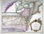
Gilles Robert de Vaugondy (French, 1686-1766)
PARTIE DE L’AMERIQUE SEPTENTRIONALE, QUI COMPREND LE COURS DE L’OHIO, LA NLLE. ANGLETERRE, LA NLLE. YORK, LE NEW JERSEY, LA PENSYLVANIE, LE MARYLAND, LA VIRGINIE, LA CAROLINA, c. 1755
Map printed on paper, hand-colored; 20" X 26"
khs.map.
Courtesy Kentucky Historical Society
Though this map bears a 1755 imprint, it was included in the Atlas Universel by Robert de Vaugondy, G., and son, published in 1757. The map shows North America east of the Mississippi River, from Maine and Ontario to South Carolina. An inset map shows an additional portion of the South Carolina coast and a portion of coastal Georgia. Virginia extends to the Mississippi River, including the region that became Kentucky in 1792. Reflecting the politics of the time, the map shows French and English forts, settlements, and Native American towns. Walker’s 1750 settlement is noted in present-day Kentucky. There are also comments on the characteristics of some rivers. The map title appears in an ornate “cartouche,” a typical graphic element for maps of this era.
About the Artist
Gilles Robert de Vaugondy (1686-1766) was geographer to the king of France. Assisted by his son, Didier Robert de Vaugondy (1723-1786), he published the world atlas Atlas Universel in 1757. M.C. Boussaird engraved the map for Robert.
Classroom Ideas
Discussion: How does this map compare to contemporary maps in your classroom, or other maps you have used, in terms of purpose, presentation, and appearance? Analyze this map using the discussion worksheet at the National Archives (see link below). Is this map art? What skills and knowledge are required to create a map? Which of these are artistic skills? Why do you think this map is in French?
Activity: Create a map of the school neighborhood or your community in a style similar to this one.
Note: This image also relates to social studies content regarding maps and their purposes.
Links
For more about early attempts to map Kentucky, see the Maps, Early entry in the Kentucky Encyclopedia (subscription required for online version).
[www.kyenc.org/perl/entry_result.perl?ID=MAPSE01&words=Printers&SearchType=Full]
The National Archives web site includes a Map Analysis Worksheet.
[www.archives.gov/digital_classroom/lessons/analysis_worksheets/map.html]
Links to additional mapmaking activities and lesson plans can be found at the companion web site for KET’s instructional series Art On-Air.
[www.ket.org/artonair/teachers/lessonplans.htm]