Creating an image map
You can divide an image into multiple parts and link the parts
(called hotspots) to different pages in your Web site. When
you create an image map, you link different parts of the image to
separate destinations.
You can create client-side image maps and server-side image maps.
Client-side image maps are easy to implement, because they eliminate
the need for a CGI script, which is required by server-side image
maps, and they may perform faster because of the reduced demand on
the server processor. However, some older browsers such as Mosaic and
earlier versions of Internet Explorer and Netscape Navigator do not
support the client-side image map.
If you want to accommodate people who have newer browsers and
those who have older browsers, you might consider creating both a
client-side and a server-side version of each image map on your Web
site. You also might consider using several individual images as
links instead of an image map.
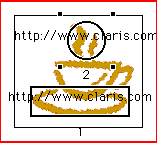
To create either kind of image map, you need to assign
hotspots to the image. Hotspots are hypertext areas on an
image map that people can click to jump to different URLs.
Creating a client-side image map
When you create a client-side image map, you draw hotspots over
parts of the image and link them to pages or URLs. You can make the
areas of an image that aren't covered by hotspots link to a default
URL. When someone clicks on the image map but doesn't click on a
particular hotspot, the default link is activated.
To create a client-side image map:
- Select the image and choose Object Editor from the View menu
(Windows) or Show Object
Editor from the Window menu (Macintosh).
- Click the Behavior tab, if necessary.
- Click the Image
Map radio button, and then click the Edit button.
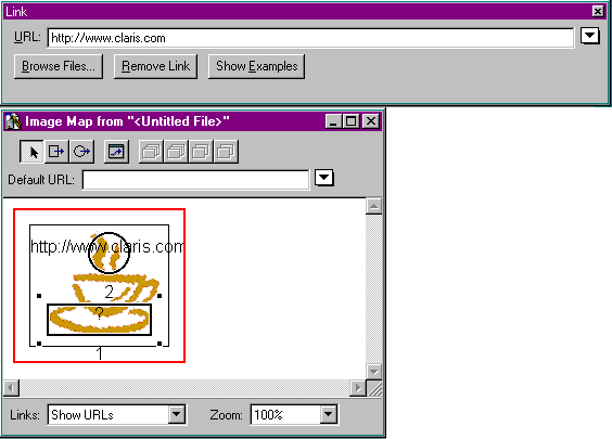
The image file opens in the Image Map Editor.
- Use the Zoom pop-up menu to increase the
magnification of the image.
- Select the Rectangular Link
 or the Circular Link
  tool on the toolbar and draw a rectangle or circle over the area
of the image that you want to be a hotspot.
tool on the toolbar and draw a rectangle or circle over the area
of the image that you want to be a hotspot.
When you are finished creating the hotspot, the Link Editor
appears.
- Type the filename or URL of the link destination in the
URL text box
or choose it from the URL pop-up menu.
- Repeat steps 5 and 6 to create other hotspots in the
image.
Claris Home Page consecutively numbers each hotspot as you draw
it, with smaller-numbered hotspots in front.
Note If you draw
hotspots that overlap each other, hotspots in front take
precedence over the ones in back. Use the Move Link buttons to
change the order that layered hotspots are used.
- For areas that aren't covered by a hotspot, type a URL in the
Default URL
text box or choose it from the Default URL pop-up menu
- Close the Link Editor and the Image Map Editor.
To remove all hotspots and destination URLs from an image map:
- Select the image.
- Choose Object
Editor from the View menu (Windows) or Show Object Editor
from the Window menu (Macintosh).
- Click Clear.
Creating a server-side image map
It is useful to provide server-side image maps for members of your
Web audience who may have old browsers. Making a server-side image
map work requires an available CGI image map program or equivalent
software supported by your Web server. You must also choose what type
of server-side image map is supported by your Web server or Internet
service provider, NCSA or CERN.
To set the type of server-side image maps you create:
- Choose Application
Options from the Tools menu (Windows) or Preferences from the
Edit menu (Macintosh).
- Choose
the
Images tab, if necessary.
- Set the Image Map
Format option to NCSA or CERN.
- Click OK.
To create a server-side image map:
- Select the image and choose Object Editor from the View menu
(Windows) or Show Object
Editor from the Window menu (Macintosh).
- Click the Behavior tab, if necessary.
- Click the Image
Map radio button, and then click the Edit button..
The image file opens in the Image Map Editor.
- Click the Create
Server Side Image Map check box.
- Use the Zoom pop-up menu to increase the
magnification of the image.
- Select the Rectangular Link
 and the Circular Link
  tools to draw hotspots in the image.
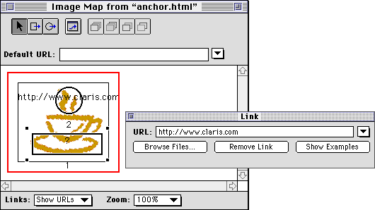
The Link Editor appears for every hotspot you draw.
- In the Link Editor, Type the filename or URL for each hotspot
link destination in the URL text box.
To specify a default URL for the image map, type the URL in the
Default URL
text box or choose the URL from the pop-up menu next to the
Default URL
text box.
Claris Home Page consecutively numbers each hotspot as you draw
it, with smaller-numbered hotspots in front.
Note If you draw
hotspots that overlap each other, hotspots in front take
precedence over the ones in back. Use the Move Link buttons to
change the order that layered hotspots are used.
- Save your image map file by choosing Save from the File menu, and
then close the Image Map Object Editor.
The image map file is named the same as the image file except that
the extension is .map instead of .jpg or .gif. This map file is
created in the same folder as the image file.
- With the image still selected in your page, choose Link to URL from the
Insert menu or click the
Link Editor button
 on the toolbar.
The Link Editor appears.
- For most ISPs, you will need to type the pathname of the
image- handling script and map file name in the URL text box.
Depending on your ISP, you may type something like this for a CGI
called "imagemap" and an image file called "picture.gif," which
would have a map file called, "picture.map":
/cgi-bin/imagemap/~myfiles/images/picture.map
Note Check with your
ISP for the format of this link.
- Close the Link Editor.
- Save your Web page.
Important Talk to
your Web server administrator or Internet service provider to get the
Web server requirements for using a server-side image map. Some Web
server software may have built-in image map support, and not require
an additional CGI, though they still may require either a NCSA or
CERN image map format. Other servers may require a special file name
extension for the map file other than the .map extension that Claris
Home Page creates.
For more information on server-side image map issues, see http://
www.claris.com/support/products/clarispage/.
To remove all hotspots and destination URLs from an image, select
the image, open the Image Map Object Editor, and click Clear.
You can test the image map links in Preview Page mode. For more
information, see Testing the links.
Previous topic |
Contents | Next
topic