
Geologic Division /
Coastal and Marine Program /
Woods Hole Field Center
Map-It: Form-based Simple Map Generator
This form takes longitude/latitude pairs as input and plops them
on a Mercator projection map along with land/sea and political boundaries.
The map bounds will be about 10% larger than the bounds of the entered
data points.
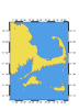
The default values on the form below yeild a nice map of Cape Cod, Massachusetts,
generated by supplying the longitude and latitude values of Cape-area towns:
Woods Hole, New Bedford, Nantucket, Chatham and Provincetown.
The map is by "pscoast," part of the
freely available GMT package, version 3. The form
processing, GMT script generation and execution, and
image manipulation is accomplished by
an ugly little Perl script .
The URL of this page is http://crusty.er.usgs.gov/mapit/index.html
Last modified: Thursday, 14-May-98 14:36:22 EDT
For comments and questions, contact
Rich Signell