 |
allow you to get your bearings |
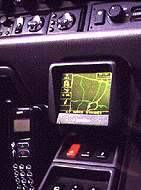
The vector map shows you all the roads in the area and the route the system has plotted. The view has a zoom from 0.1 of a mile (not detailed enough) to five miles (too crowded) but gives a good view of other routes. The test disc even held some roads on Ministry of Defence land which are not shown on normal maps. In addition to the map, the vector display shows panels containing a small version of the direction arrow which points directly towards your destination, a compass pointing to magnetic north and the number of GPS (global positioning system) satellites in view.
You can use the vector map to get a feel for what lies ahead. The view rotates to show the forward direction. Once you have used the system for a little while, you become confident in it and can relax with the simple spoken directions. These say things like: "Prepare to go straight ahead in 300 yards", or "Take the next left followed by a sharp right". All the instructions are precise and clear.
 |
 |
 |
 |
 |
 |
 |
 |
 |
 |