| Extreme Weather |
| Hazardous weather conditions can arise at various locations and time of year. Severe blizzards can sweep across North America on cold northwesterly air fronts in the winter, with drifting snow and icy winds disrupting transport and power supplies. Heavy rainfall regularly causes great rivers such as China's Yangtse to flood. In sub-Saharan Africa, prolonged drought has led to desertification and famine.
This weather satellite image shows snow cover across the eastern USA after a severe blizzard in January 1996.
Heavy rain from a cyclone turned ash deposits from the eruption of Mt Pinatubo into lahars - damaging mudflows.
This Landsat image shows the extent of flooded land in Mozambique after heavy rain swelled the Zambezi River in February 2000.
Radar imagery overlaid on a visible-wavelength image shows the areas flooded by the Mississippi and Missouri Rivers in August 1993. Areas adjacent to tropical oceans are at risk from violent tropical storms (cyclones), called typhoons in the Pacific and hurricanes in the North Atlantic. Tropical cyclones kill, on average, 20,000 people a year. Apart from the high winds, waves and heavy rainfall, much of the damage is caused by storm surges, where the sea is pushed up ahead of the storm, flooding coastal areas. Powerful tropical cyclones can persist into temperate regions, returning across the ocean basin at higher latitudes as low pressure systems. Temperate coasts are also at risk from storm surges when the arrival of very low pressure systems coincides with high tides.
This 3D view of Hurricane Hugo off the US west coast in 1989 was derived from a weather satellite image.
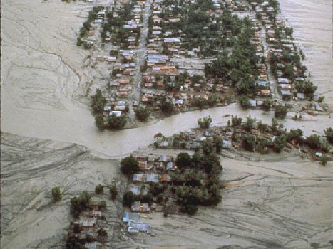
Hurricane Mitch cut a swath of destruction across the Caribbean and Central America in October 1998.
A remnant of Hurricane Grace, this extremely violent low pressure system off Cape Cod in October 1991 was dubbed "the Perfect Storm". Tropical cyclones can grow to over 700km (440 miles) in diameter and last up to a week. Much smaller are tornadoes - short-lived areas of extremely low pressure extending from supercell thunderstorms in temperate continental interiors - particularly the Great Plains of the USA in spring and early summer. In addition to winds of 180-360km (112-225m) per hour , damage is caused by buildings exploding due to the sudden pressure drop and material being sucked up into the vortex. On average, 100 people a year are lost to tornadoes, although 689 were killed by a single tornado in 1925, which travelled 200km (125m) in 3 hours across Missouri, Illinois and Indiana. Where tornadoes occur over coastal water, they are termed seaspouts.
This GOES weather satellite image shows a line of supercell thunderstorms which unleashed tornadoes across west Texas in May 1997. |