 |
|||
|
Polar ice cap
|
|||
| ICE ON MARS | |||
| The polar caps of Mars can be seen from Earth, even with small "amateur" telescopes. The first observation of the southern polar cap may have been by Christiaan Huygens in 1672. Before spacecraft visited Mars, observers had already noticed seasonal changes occurring in the caps - they would alternately melt and then freeze. These apparent seasonal changes helped fuel speculation that water was being transported across the planet from the ice caps through a network of canals, built by Martian engineers. As well as growing and shrinking ice caps, the rest of the planet would subtly change its colour. This was explained by the growth and decline of Martian vegetation as it was fed or starved of water from the ice caps. | |||
| Seasonal change | |||
| The seasonal changes of the ice caps can be seen in these images from the Hubble Space Telescope (HST). The HST cannot see the Martian polar regions from above, and so these views were obtained by reprojecting the original HST images to appear as they would from above. The images below show the slow retreat of the ice cap as the Martian season goes from late winter to early summer. | |||
 The left view, late winter, shows the northern ice cap at its maximum extent, reaching as far south as 60N. Earth's ice cap does not reach as far south, but this is to be expected as Earth is closer to the Sun and warmer. The right-hand image shows northern Mars during the summer season. The ice cap has now retreated so much it reveals Chasma Borealis, a deep canyon that almost splits the ice cap in half. The middle image, showing the ice cap during the Martian spring, sees the ice cap retreat to 70N. At this latitude can be found dark circumpolar sand dunes, which are easily warmed by the Sun, and hence lose the ice more rapidly. |
|||
 Viking Orbiter 2 image. |
|||
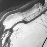
| This Viking Orbiter 2 image was taken in the late northern spring, during the seasonal retreat of the ice cap. The dark lines are where the ice and frost has melted to reveal the darker underlying Martian soil. The southern polar cap undergoes greater seasonal change, because a southern winter on Mars is far more severe than a northern winter. During the southern summer, the combined effects of perihelion and axial tilt force the southern cap to undergo extra melting. The southern cap shrinks to a diameter of only 350 kilometres, compared with the northern cap that shrinks to 1000 kilometres during the northern summer. | |||
| Structure | |||
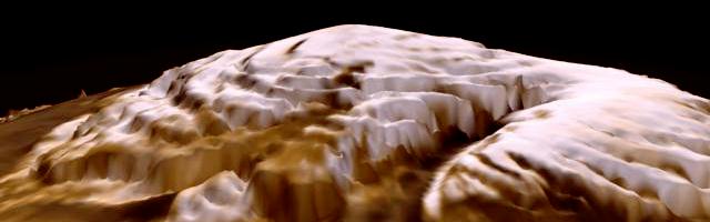
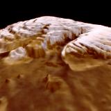
| As the ice cap retreats, it reveals the underlying terrain, which consists of deep valleys. The direction of these valleys is what gives each cap a swirl pattern, as seen in this mosaic of Viking Orbiter images. | |||
 Polar ice cap |
 Polar ice cap |
||
| The right-hand image is derived from Mars Global Surveyor data, an orbiting spacecraft that carries a laser altimeter. Precise height measurements show that the ice cap is at most 3 kilometres deep, and cut by canyons as deep as 1 kilometre. The deep canyons may have been cut into the ice cap by wind erosion. Apart from the canyons, the rest of the ice cap seems to be very smooth; over several kilometres the height only varies by a few metres. There also appears to be the remains of an ancient ice cap, in the form of large ice hills, several kilometres across and up to a kilometre in height. | |||
| Composition | |||
| The winter temperature drop differs between the two polar caps: -68oC during the northern winter and -140oC during the southern winter. A temperature of -68oC is not cold enough to freeze carbon dioxide (CO2), but it will of course freeze water. This demonstrates that the northern ice cap is composed mainly of water. Southern ice cap temperatures of -140oC are cold enough to freeze CO2. Coincidental with the growth of the southern ice cap is the planet wide drop in atmospheric pressure. | |||
| As the bulk of the Martian atmosphere consists of CO2, the pressure drop is easily explained by CO2 super freezing in winter. The southern winter sees the pressure drop by 25%, caused by a large fraction of Martian air freezing and forming the ice cap. The southern cap therefore is a mixture of water ice and CO2 ice. When southern temperatures climb above the freezing point of CO2 the ice goes straight from solid to gas without becoming a liquid. | |||
| Global atmospheric pressure rises as the CO2 returns to the atmosphere. However, the residual cap, the small component left in place during the summer, must be made of water, because summer temperatures are below the freezing point of water, but above the freezing point of CO2. | |||
| Laminated polar deposits | |||
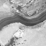
| Surrounding both Martian poles, are thick sequences of deposits that show a layered, or laminated, structure, extending to about the 80 degree latitude circle. This Viking Orbiter 2 image (below) shows polar valleys near the north pole; within the valleys can be seen light and dark layers. The laminated areas lack craters, implying a young surface that has not been subjected to ancient meteoritic impact. Some scientists have estimated the age of this terrain to be only 100 million years. However, this may only be the age of the exposed, visible, terrain. | |||
 Viking 2 orbiter image. |
|||
 |
 |
 |
|
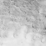
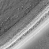
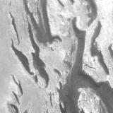
| Polar laminated terrain is also visible in this sequence of images. Each image, shows progressively greater detail. The first is a 1977 view taken by Viking Orbiter 2, and shows detail down to about 160 metres. Mariner 9 captured the second image in 1972 and obtained a resolution of 100 metres. Both Mariner 9 and Viking Orbiter 2 took the pictures during the Martian northern summer. The highest resolution occurs in the third image, taken by the Mars Global Surveyor spacecraft on Christmas Day, 1977, and reveals features only 25 metres across. | |||
| The linear features are layers that have been exposed by wind erosion. The layered deposits seem to have different textures, implying different physical properties or composition. The layers are believed to be made up of a mixture of ice and dust, with the dust making up 5% of the total. If the amount of dust mixed with the polar ice has changed as a result of changes in climate and wind circulation, the effects might be found today, locked into the laminated deposits. It is hoped that the new Mars Polar Lander mission will investigate the polar laminated terrain, and return data that can tell us more about the history of the Martian climate. | |||
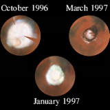
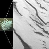 This image shows the location of the right-hand image in the southern polar cap. |
 This image was taken by Viking Orbiter 2 during the Martian southern summer, when the dark regions are clear of ice and frost. |
||
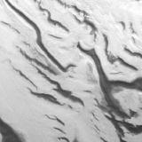 Improved resolution was obtained by Mariner 9, as seen in this image, and greater detail can be seen in the laminated areas. Again, this is a summertime view. |
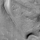 Springtime view. |
||
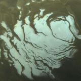
| The Mars Global Surveyor image covers a region approximately 30 kilometres across, with each pixel (picture element) covering 50 metres. In this springtime view (above), the slowly increasing warmth from the Sun has yet to clear the ground of ice. As this is part of the permanent ice cap, not even summer temperatures will remove all the ice. Again, there is a variety of texture on display, possibly caused not just by short-term freezing and sublimation (solid converting to gas), but maybe caused by variations in the Martian climate over millions of years. | |||
| The future | |||
| Precession, the slow wobble of the Martian rotational axis, is slowly changing the tilt of the axis. In 25 thousand years time, the current condition will have reversed, with the northern, not the southern, hemisphere suffering the worst winters and the lowest temperatures. When this happens, the northern polar cap will grow to be the larger. | |||
| Then, as the lowest temperatures occur in the north, this will be where the carbon dioxide freezes, and the southern cap will become merely a small water-ice cap. Precession takes place over a 100,000 year cycle, therefore the polar caps have already swapped composition and behaviour many times over. Today we only see a frozen snapshot. | |||
|
|
|||