 |
||
|
The
surface of Mars shows evidence of the flow of water.
|
||
| THE CHANNELS OF MARS | ||
| The atmosphere of Mars today is such that water cannot exist as a liquid on the surface. Valleys cut by flowing water are the main indication that the planet was at some stage in its history warm and wet. Although most people agree that water was responsible for creating valley networks on Mars, alternative fluids have been suggested, including lava, mud, glacier ice, and even liquid hydrocarbons. | ||
| There are three main types of drainage feature on Mars formed by water, and each quite distinctive. They are channels, valley networks, and fretted terrain. | ||
| Channels | ||
| Channels, or "outflow channels", extend from chaotic terrain where they originate. They cut through the plains for hundreds of kilometres. They have several characteristic features. Outflow channels are wide for all of their distance, varying little in width, and they have no tributaries (smaller channels) draining into them. Outflows are particularly wide and deep near their source. | ||
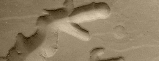
| The channel floors have fine ridges along them. These are scour marks made by the fast flowing water. Scour marks converge when the channel is constricted. They diverge when the channel is widened. In the outflow channels east of Vallis Marineris there are tear-drop shaped islands. They have a rounded upstream head and a pointed downstream tail. These islands resisted erosion because they were tougher than the surrounding materials. They show that the channel was cut by fast flowing water. | ||
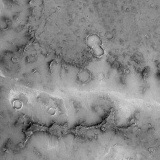
 Islands on the floor of Maja Vallis. |
 Long grooves, and islands the shape of teardrops, within Maja Vallis. |
|
| There are many other signs that major, perhaps even cataclysmic, flooding took place. For instance, there are scabby depressions where the water, rather than scouring the surface, has plucked away large chunks of the surface, thereby leaving rough hollows. | ||
| Calculations based on the sizes of the channels indicate they were formed by a fluid flowing at a rate of about 108 cubic metres per second. The Amazon river on Earth flows at an average at 105 cubic metres per second. The largest known flood on Earth occurred in the Pleistocene, with an estimated flow rate of 106 cubic metres per second. It can be seen that the floods on Mars were catastrophic and larger than any known on Earth. | ||
| How the flooding begins is slightly more difficult to decide. The channels clearly start at the chaotic terrain (sometimes known as "chaos"). This landscape of jumbled blocks could have resulted from collapse as the flood burst from underneath. The volumes of water needed to carve the channels suggest that the area of collapsed terrain is small compared to the great underground networks that could exist beneath Mars. If the water was stored underground as ice, it may have been melted by volcanic heating. Another way in which the channels could have formed is by a sudden release of water stored in lakes on the surface. If they were confined by a natural dam, an earthquake or collapse may have caused it to burst. | ||
| Because outflow channels may have formed in a way that doesn't need liquid water to be present on the surface, they could have formed under conditions like those on Mars today. That is to say, quite recently in Mars' history. | ||
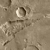 The Ravi Vallis outflow channel emerging from chaotic terrain. |
||
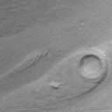
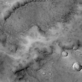
| The most extensive outflow channel is located on eastern edge of the Tharsis bulge. It appears to have been cut by a combination of mass flows (containing solid material) and concentrated floods. The outflow originated in the chaos of Margaritifer Sinus to the south of the Chryse Basin and flowed northward into Chryse, where several other large channels also drain. From the Chryse the main outflow extends even further into the low-lying northern plains. | ||
 Evidence of surface flow around Dromore crater, Chryse Planitia. |
||
| Valley networks | ||
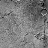
| Valley networks on Mars look like drainage channels cut by water on Earth. Although they tend to be smaller than drainage networks on Earth, the resemblance is striking. Valley networks have a branching structure, with the tributaries feeding into channels which get progressively wider downstream. The channels themselves are V- or U-shaped in cross section. | ||
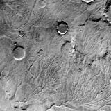
 Part of a valley network in central Terra Meridiani. |
 A Terra Meridiani drainage valley as seen by the Mars Global Surveyor. |
|
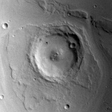
| Most of the valley networks found on Mars occur in the highlands, having formed after the intense cratering which took place during the early history of Mars. There are also complex drainage networks on many volcanoes, resembling the water cut channels sometimes seen on terrestrial volcanoes. | ||
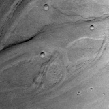
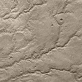
 Viking orbiter image of a drainage network in the southern highlands. |
 Southern highland drainage network showing features similar to drainage patterns on Earth. |
|
| The valley networks are thought to have been formed more gradually than the outflow channels. They therefore show that water could exist on the surface for a reasonable length of time. Many of the valley networks have an interconnecting or braided pattern while other parts the network are dominated by a large meandering channel. | ||
 Viking Orbiter 1 image of the Parana Valles, a valley network in the Margaritifer Sinus region. |
||
| Fretted terrain | ||
| Fretted terrain is very peculiar looking. It consists of an irregular twisting, canyon network, with U-shaped channels. Nearer the margins of the terrain there are outliers or free-standing plateaux. The main channels have tributaries. They have flat bottoms and broaden down stream. They look like they have been formed by water, and in places scour marks can be seen. It is possible that the fretted terrain began as an underground river network which eventually caved in, exposing the channels. | ||
|
|
||