 |
|||
|
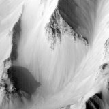
Computer-generated
perspective view of Candor Chasma.
|
|||
| THE CANYONS OF MARS | |||
| Canyons on Mars are different from channels and valleys. Although canyons are modified by erosion, they are formed initially by rifting and faulting of the surface. Extension of the surface may cause a trench to form. The surface collapses in a linear block called a "graben". Even if such tectonic activity stops immediately, removal of material by wind and water can continue to enlarge the canyon. | |||
| Marineris Vallis (Mariner Valley) is a vast system of interconnected canyons spanning a quarter of the planet's circumference. The canyons run from Noctis Labyrinthus for 4500 kilometres until they meet with the chaos terrain in the south of Chryse Planitia. | |||
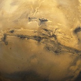 Valles Marineris, the Solar System's largest canyon. |
|||
| At its widest central section, where there are three parallel canyons Ophir, Candor and Melas, Marineris is 600 kilometres across and 8 kilometres deep, making it six times wider and four times deeper than Earth's Grand Canyon. Though further away from the centre of Marineris the canyon becomes shallower, with a depth of between 2 to 3 kilometres. | |||
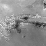 The eastern end of Valles Marineris. |
|
||
 Computer-generated perspective view of Ophir Canyon, seen from the west. |
 Valles Marineris compared with Earth's Grand Canyon. |
||
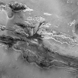
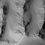
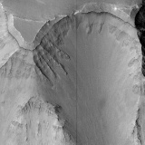
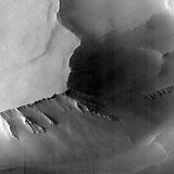
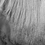
| Landslides | |||
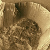
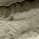
| The walls of the canyon are very steep and huge landslides have occurred, which widen the canyon even more. The landslides leave behind a curved cliff face. Along the wall are and sometimes on the cusps of the remaining wall are triangular facets which are thought to indicate faulting. | |||
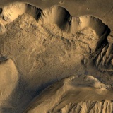 Viking Orbiter image of huge landslides in the Ophir Chasma canyons of Valles Marineris. |
 Landslides in the Ophir canyon. |
||
| The collapsed material at the base forms a rugged jumble of blocks and rocky debris, while further out is a fan of smoother materials with a low rounded front. The smooth material is thought to have moved like a fluid, very quickly, over the floor of the canyon. Some of these debris fans cover large areas and stretch right across the canyon floor, even blocking it in places. | |||
 Viking Orbiter 1 image of landslides in the 6 kilometre deep Tithonium Chasma. |
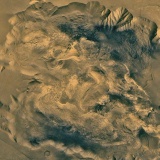
Catastrophic collapse and flow features in West Candor Chasma. |
||
 Mars Global Surveyor view of collapsing walls in the Tithonium Chasma. |
|||
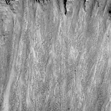
| Erosion | |||
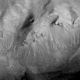
| There is much evidence of wind erosion throughout the canyon system - some canyon floors are covered with sand dunes, and rock outcrops have been scoured by wind, leaving a pile of debris on the floor. | |||
 Sand dunes on the floor of Melas Chasma. |
 The floor of Melas Chasma, Valles Marineris, showing sand dunes as a result of wind erosion. |
 Wind-blown drifts on the floor of Tithonium Chasma. |
|
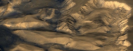
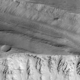
| Layers | |||
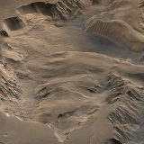
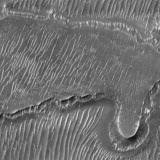
| A particularly remarkable result of the Mars Global Surveyor mission has been the discovery of layers within the walls of Valles Marineris. Many exposed areas of rock clearly show layering, sometimes going down to great depths. The formation mechanism of the layers is still unknown - some argue that they are the result of sedimentation processes involving water and wind. Others argue that they have a volcanic origin. Another suggestion is that sedimentation layering may represent the different Martian seasons. The orbit of Mars is eccentric, and there is a large seasonal change as a result of the varying amount of sunlight reaching the planet. The resultant global dust storms, and planetwide deposit of material, may be one mechanism (amongst others) that has built a layered surface. The formation of Valles Marineris has now revealed those layers. Either way, it is clear that Valles Marineris can provide much information concerning the early history of Mars. | |||
 Evidence of layering in the gullies of Valles Marineris. |
 Rock layering (possibly from sedimentation) on the slopes of Valles Marineris. |
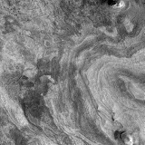 Horizontally-bedded layers exposed on the floor of western Candor Chasma. |
|
| The formation of Valles Marineris | |||
| Though there are several ideas as to how Vallis Marineris was created, these differ only in detail as most scientists agree that the rift was produced by extension. | |||
| This can come as a surprise, for Valles Marineris is nearly always compared to Earth's Grand Canyon, a canyon formed by the down-cutting of the Colorado River. A leap of the imagination then concludes that the same process has been at work on Mars. However, the forces which pulled the Martian surface apart, forming graben, are thought to have been generated by the uplift of the volcanic Tharsis region. As the bulge grew, radial fractures were formed on the surface. The fracture that widened more than the others became Valles Marineris, with the original surface collapsing in several places.Once faults and scarps began to appear, the resulting cliff faces and other cracks in the surface could be exploited by erosion by wind and water. Some researchers have even suggested that erosion is entirely responsible for the formation of Vallis Marineris, though most argue that erosion could only have removed some, not all, the material. | |||
 Layering in the rock outcrops of Ius Chasma, viewed by the Mars Global Surveyor. |
 Evidence of rock layering in the walls of Tithonium Chasma. |
||
 Canyons, 2 kilometres deep, in the Labyrinthus Noctis. |
 Debris that has been sculpted by wind. |
||
|
|
|||